Daily monitoring of the tropical Indo-Pacific SSTs suggests to me our cold event is on the wane (seasonal cycle understood). Anomalies throughout the equatorial belt are weak, ~plus/minus 0.5C, with values at around 200m depth still ranging from ~plus 1-2C west of date line with comparable negative values for the east Pacific. Additionally, there has been an eastward shift of the coolest tropical Pacific water for at least the past 2-4 weeks. That translates to 27 and 28C SSTs moving into the WH, while the critical 29C and greater waters have still remained west of date line into the IO as well as the South Pacific. Please see the link below for details.
http://www.pmel.noaa.gov/tao/jsdisplay/
The tropical convective forcing has just completed another ~30 day EH variation with the recent eastward movement from the IO into Indonesia (see previous postings). This is the third event since early January, and at least the first and most recent events have had MJO components to them. The time-filtered OLR/OLRA coherent modes Hovmollers from both ESRL/PSD and BMRC nicely summarize these behaviors (links below).
http://www.cdc.noaa.gov/map/clim/olr_modes/hovEa.html
http://www.cdc.noaa.gov/map/clim/olr_modes/
http://www.bom.gov.au/bmrc/clfor/cfstaff/matw/maproom/OLR_modes/index.htm
During January, event #1 robustly moved into the region of the southwest Pacific, and strongly enhanced thunderstorm activity along the South Pacific Convergence Zone (SPCZ). That added zonal mean westerly flow to the atmosphere, and global relative AAM did increase ~2 standard deviations. There was a SDM Stage 3 response by early February (details given on our most recent weather-climate discussion).
http://www.cdc.noaa.gov/people/klaus.weickmann/disc021506/weather_climate_discussion_10Feb06.html
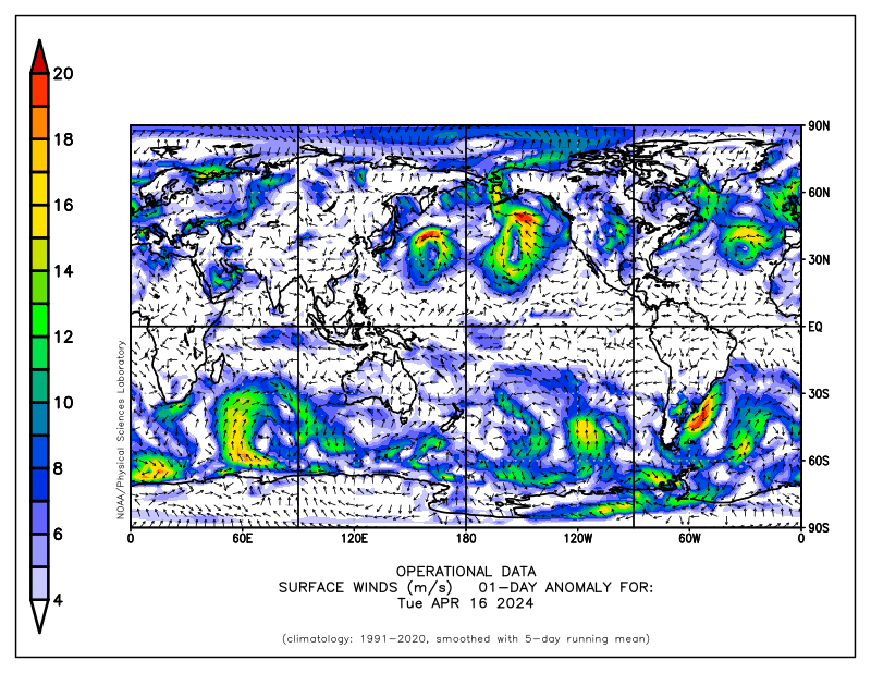
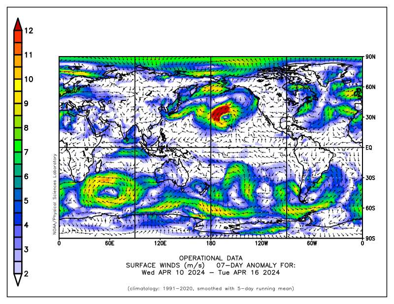
Our recent event exhibited a similar behavior to #1; however, the enhanced convergence was roughly 40 deg. farther west (consistent with La Nina), and extended from the South IO through northern Australia into the southwest Pacific (centered ~10S/130E). A strong surface westerly wind event (WWE) accompanied this situation, with weekly mean anomalies of at least 8-12 m/s. Links below show a few relevant graphics. It is interesting to speculate, given our ~30 day tropical convective variabilty "going on", what might be the response of the tropical Pacific SSTs should the next WWE occur on the equator instead of south of the equator. I might also add the recent increase of the surface easterlies across the west Pacific were perhaps linked to a vertical circulation response tied to the recent flare-up due to event #3.
http://www.cdc.noaa.gov/map/images/fnl/sfcwnd_01a.fnl.gif
http://www.cdc.noaa.gov/map/images/fnl/sfcwnd_07a.fnl.gif
The link below goes to an experimental model for predictions of tropical Indo-Pacific SSTs. What is interesting is that the model is run in real-time (details on the web page). Whatever the case may be, uncertainty about the future course of ENSO is very high, particularly during boreal spring (so-called spring barrier of predictability). Let us just see what really happens.
http://www.bom.gov.au/bmrc/ocean/JAFOOS/POAMA/exproducts/poama_v10/fc_rt_nino_l30.htm
During the last ~5 days the tropical convective forcing has become less coherent, with even a signal of a convectively coupled Kevin wave moving well into the WH as I type. Per full disk satellite imagery, the main region of tropical convection extended from southeast Asia/northwest Indonesia east-southeast across northern Australia into the South Pacific Ocean. Other transient flare-ups were occurring across northern South America and central Africa. Any MJO signal is very weak (see below).
http://www.bom.gov.au/bmrc/clfor/cfstaff/matw/maproom/OLR/m.3d.html
http://www.bom.gov.au/bmrc/clfor/cfstaff/matw/maproom/RMM/phase.Last90days.gif
http://www.ssec.wisc.edu/data/geo/mtsat/
An important point is that upper tropospheric westerly wind anomalies have appeared across tropical Africa and the IO, where easterlies were present about a week ago. Westerly flow has been generally increasing throughout the tropical and subtropical atmospheres for the past couple of weeks or so, with 200mb zonal mean anomalies ~5 m/s. This can all be attributed to convective event#3 discussed above, and a consequence we are now seeing is that the EAJ is extending into the North Pacific with 250mb anomalies ~20-30 m/s. This jet is being directed in an anticyclonically curved manner across our now familar central Pacific ridge and will impact the west coast of the USA during the next few days. Meanwhile, zonal mean easterly anomalies continue across the Arctic, suggesting more split flow for North America. Please see the link below to study some animations of various fields.
http://www.cdc.noaa.gov/map/clim/glbcir.anim.shtml
Global relative AAM is still ~2 standard deviations below the 1979-1998 climatology, due to anomalous easterly flow throughout the tropical and subtropical regions (vertically and zonally averaged). Punch line is that SDM Stage 2 may now best describe the circulation at least for the tropics and subtropics, with complex interactions outside the tropics given our La-Nina base state. Hovmoller presentations of numerous fields suggest the atmosphere started to persist in a SDM Stage 1 regime beginning about the middle of February, with perhaps a subtle change to SDM Stage 2 about a week-10 days ago. If this is indeed the case, that would go well with discussions in previous Blog postings.
http://www.cdc.noaa.gov/map/images/aam/glaam.gif
For the PNA sector that would support a stronger than climatology North Pacific jet (over the ridge) with troughs penetrating inland into the western USA instead of first digging off the coast. This would be in the presence of split flow with "lots of high pressure" particularly over eastern Canada into the North Atlantic (which may continue a negative projection onto the NAO). Ensemble numerical models such as from CDC, NCEP and CMC have been trending toward this notion for the past week. While the details are unclear, I think that direction is reasonable. I think at some point we may see a full-latitude ridge develop just off the North American west coast, possibly toward the end of week 2 (I have my reasons).
This all translates to a continuation of a very active weather pattern for the CONUS for at least the next 2 weeks. In fact, perhaps even more so for the Rockies and Plains. Additionally, if there is any truth to La-Nina weakening, I could see more transient strong western USA troughs for several more weeks. By now, everyone should understand the potentially high impact weather events from all this.
For southwest Kansas, it all comes down to the tracks of each baroclinically developing trough whether we get storms, southwest wind heat and dust storms, both, etc. I have some optimism (not wishing for damage, etc.) for rain/storms around the end of next week/weekend. In general, I would think there will be opportunities for thunderstorms at least ahead of the drylines. As usual, better opportunities for precipitation will be to our east and north. Both temperatures and probably the surface wind will average above normal for at least the next two weeks.
I will try to post another (hopefully shorter) update around the middle of next week.
Ed Berry
No comments:
Post a Comment