“The views expressed are those of the author and do not necessarily represent those of the National Weather Service.”
Best regards,
Ed Berry
“The views expressed are those of the author and do not necessarily represent those of the National Weather Service.”
"The views expressed are those of the author and do not necessarily represent those of the National Weather Service.”
Time constraints preclude a complete discussion. In fact, at this point that may be case for at least the rest of this summer. The 6 June 2009 posting has all relevant links. I will attempt another short writing the weekend of 11-12 July.
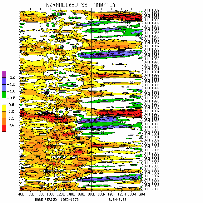
SSTs across the equatorial Pacific Ocean basin remain above normal, generally ~0.5-1C, with localized greater magnitudes west of South America. Additionally, latest TAO buoy data of 5-day averaged ocean surface waters indicate that the 29C isotherm on the equator is at about 165W, the farthest east in at least 2 years. Further, there is a separate warm anomaly along and just west of the Dateline with totals in excess of 30C. However, the subsurface anomalies in this region, while deep (~200m), are only plus 1-2C. I can easily attribute much of the central Pacific Ocean warming to strong interactions with the extratropics, including the weakened trades and actual westerlies.
The wind and convective signals are seemingly wanting to drift away from the EL-Nino attractor in WB (2009) GWO phase space (see ALL plots). Total AAM including the mass (earth) term through 30 June has dropped to more than 1 sigma below the R1 data climatology. Contributing processes include the following. As part of a dynamic response to interhemispheric meridional symmetry of zonal mean zonal wind anomalies, zonal mean low pressure anomalies are present ~35N and 45S. There has also been strong frictional dissipation of intense westerly wind flows across the Southern Hemisphere storm track regions. Should total AAM departures become comparable to that observed during this past January and February, my concerns of an El-Nino "false alarm" for the weather-climate dynamical system will be significantly raised.
Finally, responding to the global wind signals while also part of complex feedback processes (interactions with baroclinic wave packets, RWDs, etc.), strong tropical convective forcing has returned to the North Indian Ocean as well as the Eastern Hemisphere monsoon systems. A weaker but important region of convection is also present ~0/160E. Hence our nemesis of 2 areas of tropical forcing is back (other global regions understood). Furthermore, there has been some westward shifting of these regions of enhanced tropical rainfall, especially across the Indian Ocean. Which will dominate going into boreal autumn?; stay tuned. The bottom line is that the global wind and convective signals continue to lead the SSTs (broken record), and the ENSO situation is unclear (will stochastic forcing have giveth then taketh away?).
A loose superposition of the snr plots for GWO/MJO phases 8-1-2 (considering synoptic variations) still depict the global atmosphere for all fields. I suspect that will be true the rest of the summer, including the USA July trough-ridge-trough pattern possibly transitioning to more of a western trough and southeast states ridge situation during August.
Ed Berry
“The views expressed are those of the author and do not necessarily represent those of the National Weather Service.”
Please see links from the 6 June posting for current information. I am hopeful that time will allow me to present a more formal discussion next weekend, ~27 June. Whatever the case, the subseasonal dog (Rex the Rottweiler) is always watching!
The global ocean-land-atmosphere dynamical system remains tilted toward a weak El-Nino base state. Per WB (2009) measure of the GWO, the latter has particularly been the case since about mid-May. Having a contribution from frictional dissipation (negative global frictional torque) of anomalous zonal mean westerly wind flows propagating poleward into the midlatitude atmospheres, there is an on-going superimposed GWO/MJO 8-1 transition. In WB (2009) GWO and WH (2004) MJO phase spaces, the latter is probable to appear as another relatively minor orbit displaced toward octants 7-8-1. Phases 8-1 of the snr plots nicely depict the current global weather-climate system.
The equatorial Pacific Ocean basin is generally ~plus 0.5-1.0C warmer than normal. One important monitoring issue will be to see how much of an impact the recent strongest west Pacific WWB in roughly 2 years (~10-15m/s anomalies) has upon the thermocline during the next 1-2 months.
One regional scale response has been a convectively active Western Hemisphere, favoring deep tropical moisture transport into the central USA. I think the notion of most models to show retrogression of the trough-ridge-trough pattern across the lower 48 states during the next couple of weeks is reasonable. The latter is consistent with a brief circuit through phases 2-5 of the snr composites. By later week-2 into week-3, there may be a period of ridging around the west coast suggesting a "cool/wet trough" across the central and eventually portions of the eastern states. On average, phases 7-8 of the snr composites may best represent the global atmosphere the rest of boreal summer.
Ed Berry
http://www.cpc.ncep.noaa.gov/schemm/z500ac_wk2_na.html
“The views expressed are those of the author and do not necessarily represent those of the National Weather Service.”