Global SSTs have changed little since my last posting on April 26th. Weakly cool SST anomalies on the order of minus .5C were observed across the eastern equatorial Pacific in contrast to the plus .5C west and southwest of the date line. Subsurface anomalies of plus 1-2C extended to ~250m deep just west of the date line, with perhaps a slight deepening of the oceanic thermocline basin wide. The horseshoe pattern of anomalous warmth continued across the subtropical Pacific, while anomalous warmth prevailed across much of the tropical Atlantic. The status of ENSO (including the recent La-Nina) is indeterminate. The following links provide additional information.
http://www.pmel.noaa.gov/tao/jsdisplay/
http://www.cdc.noaa.gov/map/images/sst/sst.anom.gif
http://www.cdc.noaa.gov/people/klaus.wolter/MEI/
http://www.cpc.ncep.noaa.gov/products/analysis_monitoring/enso_advisory/index.html
After consolidating ~0/120E about 10 days ago, during the past 3-5 days there has been a fairly abrupt eastward shift of the centroid of the EH tropical convective forcing from 120-140E. A convectively coupled Kelvin wave (KW), currently moving into the WH, apparently contributed to this recent behavior. A Hovmoller plot employing time filtering to isolate coherent modes of tropical convective variability illustrates the shift (link below).
http://www.cdc.noaa.gov/map/clim/olr_modes/hovEa.html
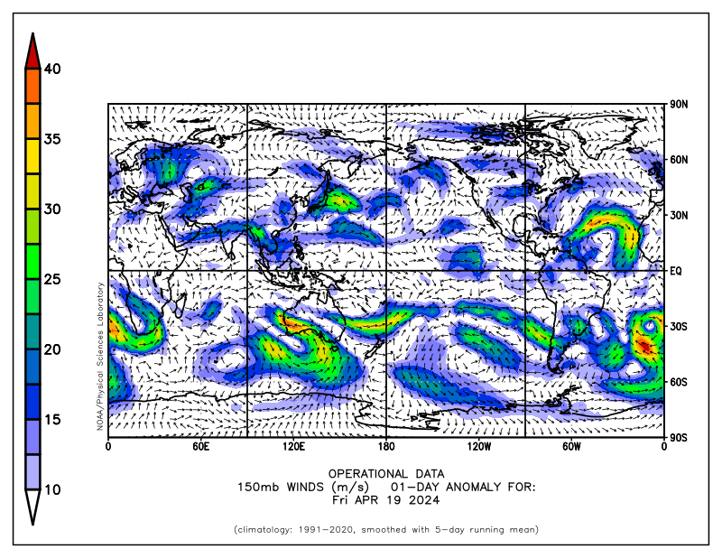
An important response to the eastward movement of the tropical convection has been a rapid increase of the zonal mean westerlies throughout the tropical and subtropical atmospheres (particularly northern), with zonal mean anomalies of at least plus 5-10 m/s. The most recent daily mean plot (29 April) of 150mb vector wind anomalies shows equatorial westerly wind anomalies in excess of 30 m/s moving across northern South America. These upper tropospheric westerlies are starting to come back around into Africa and they will impact the IO within the next few days.
http://www.cdc.noaa.gov/map/images/fnl/150wnd_01a.fnl.gif
http://www.cdc.noaa.gov/map/clim/glbcir.anim.shtml
The recent increase of zonal mean anomalous westerly flow across the tropical and subtropical atmospheres has contributed to significant positive tendency of global relative AAM (~20 Hadleys). Specifically, perhaps starting with the positive east Asian mountain torque event nearly 2 weeks ago, the complex interplay between the tropical convective behaviors and baroclinic wave energy packets (subtropical and higher latitudes) have added more westerly flow to the global circulation. These interactions have created serious sensitivity issues with all of the operational numerical models (see previous posting for model performance links) leading to, for example, above average spreads in ensemble members (understanding the role of seasonal transition). The Rossby wave energy dispersion (RWD) which contributed to the large baroclinic cyclone on the Plains at the time of this writing has been part of all these complex processes. I do believe this RWD is having a role with the current acceleration of the westerly flow (a “positive AAM tendency RWD”). In our GSDM (Global Synoptic Dynamic Model of subseasonal variability; also have used “SDM” in past postings) we try to capture these kind of multiple time and space scale interactions.
The point is I think the atmosphere is quickly transitioning to GSDM Stage 2, and I would not have expected that even a few days ago. Actual global AAM has increased roughly 1 standard deviation during the last 5-7 days, although still remains below average. There is still zonal mean anomalous easterly flow throughout a good portion of the midlatitude atmospheres of both hemispheres, a “lingering effect” of La Nina. The links below are to various plots of the AAM budget, if interested (the reanalysis plots are updated).
http://www.cdc.noaa.gov/map/images/reanalysis/aam_total/gltend.sig.90day.gif
http://www.cdc.noaa.gov/map/images/aam/glaam.gif
http://www.cdc.noaa.gov/map/images/reanalysis/aam_total/glaam.sig1-21.90day.gif
http://www.cdc.noaa.gov/map/clim/aam.rean.shtml
Where does the global circulation go from here? I do think it is plausible for convective flare-ups to occur across the east Pacific ITCZ due to warmer SSTs as the above mentioned KW moves through the WH. However, given the larger area of 29C and greater SSTs across the South Pacific, I would think it is more probable for the SPCZ to see convective enhancement during the next week or so (again, there is the seasonal cycle, which may work against that). The point is we may see a weak GSDM Stage 3 response by week 2, only to quickly collapse and revert back to the GSDM Stages 4-1 by roughly weeks 3 and 4. This scenario is quite different from what I was thinking during my last posting, and obviously my confidence is all of this is very low. However, the CDC reforecast ensemble does offer some support to this notion. Given the persistence of anomalous zonal mean easterly flow across the mid-latitudes, any extension of the east Asia/North Pacific jet would be expected to be a bit north of climatology (stated loosely to reflect uncertainty).
http://www.cdc.noaa.gov/map/images/ens_jsw/ens_jsw.html
Focusing on the PNA sector and specifically for the CONUS, GSDM Stage 2 appears most probable at least into next weekend. That would suggest a ridge building just off the USA west coast, and a trough initially digging into the Rockies before moving into the Plains (need to keep in mind the shorter wavelengths given spring). Impacts would include at least intrusions of relatively cool air initially into the northern Rockies, before spreading across the Plains and eventually to the eastern states. Most significant precipitation would be expected from the south central states possibly into the mid Atlantic region. The western states into the northern High Plains may stay dry. By week 2 (~5/7-14) the westerlies should impact the west coast, with a split flow pattern again across much of North America. I would think more strong troughs with closed lows may move through the central and southern Rockies before turning northeast. This may lead to an active storm track from the southern Rockies into at least the central and northern Mississippi Valley, including more severe local storms (with a “blocking like” ridge across central and eastern Canada). By weeks 3-4, perhaps that northwest shifted pattern of what we observed during much of March will materialize. Again, useful predictive information needs to be expressed probabilistically at these time scales for skill and accountability to be realized.
For southwest Kansas, whatever scenario the global circulation takes, it still does not look too promising for the real repeated events of beneficial rainfall everyone would like to see for at least the next 2-4 weeks. There will be a couple of opportunities for showers and storms this upcoming week ~ Wednesday-Friday. For the following week it all depends on how far south the storm track is. The above mentioned split flow pattern would be favorable for us, especially if we have a decent STJ to go with it. However, let’s just see what happens. Understanding temperature variations, the above normal tercile looks like a good bet for bi-weekly to monthly mean temperatures well into May.
I will be on travel next week. Thus it may not be until next weekend before I post another update.
Ed Berry
1 comment:
ref comment below: This would be extremely bad news to the wheat crop. Although some areas got decent rain with this last system, much of the area did not. If your outlook pans out, there will be a huge crop loss as we just don't have 2 to 4 weeks to spare. It's basically now (within 7-10 days) or never. BTW, I've had 2.50" in the last 180 days, including the rain yesterday.
Ed wrote:
it still does not look too promising for the real repeated events of beneficial rainfall everyone would like to see for at least the next 2-4 weeks.
Post a Comment