Please keep in mind the ESRL/PSD GSDM web link, below, while reading this discussion.
http://www.cdc.noaa.gov/map/clim/gsdm.composites.shtml
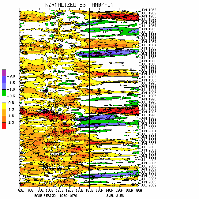
Please see links below for global SST details. Recent intense to severe tropical thunderstorm clusters has led to substantial cooling across much of the Indian Ocean. Anomalies are ~minus 1-2C with totals roughly 28-29.5C. Warmest ocean waters globally are in the region of Indonesia into the west central Pacific having totals around 30C. SST anomalies across the Nino regions are relatively minimal, and the slope of the equatorial Pacific Ocean thermocline is close to normal. Yes, the negative phase of the PDO remains well defined.
While I still think the odds tilt toward at least a weak La-Nina return during the boreal 2009-10 cold season, several very serious weather-climate monitoring issues exist that careful attention must be paid to heading into and during boreal summer. There have already been behaviors involving the weather-climate dynamical system that I would not have expected ~4-6 weeks ago. The latter emphasizes the importance of the role of poorly understood non-linear stochastic forcing.
In yet another likely futile attempt, I want to work to keep these discussions shorter. The time saved can be used for other efforts such as on going work to mainstream weather-climate discussions utilizing the WB (2009) measure of the GWO on the ESRL/PSD GSDM web page. Please leave comments and/or email me if there are questions.
http://www.wmo.int/pages/prog/wcp/wcasp/enso_update_latest.html
http://iri.columbia.edu/climate/ENSO/currentinfo/technical.html
http://www.pmel.noaa.gov/tao/jsdisplay/
http://www.cdc.noaa.gov/forecast1/IndoPacific.frcst.html (note the initial projection)
http://www.cpc.ncep.noaa.gov/products/precip/CWlink/MJO/index.primjo.html (link 19)
http://www.cdc.noaa.gov/map/images/sst/sst.long.time.io.gif
The GWO forced MJO continues to progress rapidly eastward (~8-10m/s; Kelvin wave issues understood) through the Eastern Hemisphere, having ~2.5 sigma projection in octant 4 of WH (2004) phase space through 16 April. Full disk satellite imagery and other diagnostic monitoring tools suggest the centroid of this strong MJO signal is ~0-5N/140E. My thought is that while there may be a “slow down period” across roughly the west central Pacific Ocean, the time scale of this MJO is probable to be similar to the late December 2008 into early February event. The latter was roughly 30 days, the fast end of the MJO time scale. Perhaps this is a characteristic of MJOs when stochastic extratropical dynamics are heavily involved with their initiation.
One of those serious monitoring issues I have is that our current MJO will lead to the development of a slower evolving behavior of tropical convective forcing initiating across the Indian Ocean during early May. This may eventually shift east as a MJO and contribute to a significant westerly wind burst across the equatorial west central Pacific during late May/early June. Stay tuned. In any case, the on-going MJO is already impacting the USA (to make that clear), and working with GWO processes, will continue to do so for at least the next several weeks. Only a few of those concerns can be discussed below.
Through 15 April the GWO projection is weak, less than 1 standard deviation in phase space but still tilted toward the La-Nina attractor. Clearly the MJO is dominating any subseasonal signal. However, the dynamical processes represented by the GWO continue to be very important. A research issue on the WB (endless) list of things to do is to more clearly bring out some of those processes. Remember that the WB (2009) measure of the GWO is a global dynamical circulation quantity.
For instance, tied to strong southwest Pacific tropical forcing and midlatitude mountains during the past few weeks, the eddies have worked hard essentially eliminating zonal easterly wind flow anomalies across the Northern Hemisphere subtropical atmosphere. In fact, there are even ~5m/s zonal mean westerly anomalies at 200mb around 25N, and there is an accompanying AAM transports signal. This is why many areas of the USA that had been experiencing severe drought have recently been receiving much needed precipitation.
Speculating, per MJO issues discussed above along with the GWO, maybe this “AAM rally will have legs”. Stay tuned. I continue to find it very interesting what has seemingly been a recent close relationship between the AAM and DJIA time series!
Eastern Hemisphere subtropical transition (first order baroclinic mode) is well underway involving upper tropospheric anomalous twin Indian Ocean (west Pacific) anticyclones (cyclones). Loosely, a superposition of the 250mb psi snr composite anomaly plots for MJO phases 4-5 with GWO 1-3 depict the global circulation. Current Rossby wave energy dispersion (RWD) from the Indian Ocean anticyclones into the North Pacific is one of the signals the models have been catching up to the last few days. That is probable to lead to another western USA trough/eastern states ridge during week-2, a notion offered in my 11 April posting. Afterward, weeks 3-4 may see another GWO/MJO 7-8-1-2 transition suggesting an extension of the East Asian jet across the Pacific collapsing to more strong/energetic split flow western and central states troughs/closed lows. The latter would be during the first part of May, and the storm track is likely to be shifted a bit farther north than recently observed.
Weather ramifications are well understood. For the USA, after a break next week, a resumption of an active storm track pattern focusing on the western and central states appears probable. Precipitation opportunities for many drought regions should continue. Hopefully the Gulf of Mexico will recover from yet another possible late season Tehuantepecker next week.
Appendix
All presentations from the 24 February 2009 GWO workshop are available via anonymous ftp. If you have not received information on how to retrieve these, let me know. There was excellent attendance at this day-long event, and feedback was strongly positive. We appreciate all the support!
Links to CPC and PSD ENSO discussions, and a new experimental forecast technique involving a coupled LIM (3rd link below):
http://www.cpc.ncep.noaa.gov/products/analysis_monitoring/enso_advisory/index.shtml
http://www.cdc.noaa.gov/people/klaus.wolter/MEI/
http://www.cdc.noaa.gov/forecasts/clim/
The following are links to information about the stratosphere and other nice monitoring tools:
http://ds.data.jma.go.jp/tcc/tcc/products/clisys/index.html
http://code916.gsfc.nasa.gov/Data_services/met/ann_data.html (new stratosphere link!)
The following is a link to NCEP model verifications (surf around for lots more):
http://www.cpc.ncep.noaa.gov/schemm/z500ac_wk2_na.html
The following is a link discussing recent global weather and related events:
http://www.wmo.ch/pages/mediacentre/news/index_en.html
These are probabilistic statements. We hope that an opportunity will arise for us (soon) to allow our dedicated web page effort to mature, expediting objectively and accountability. This web page effort will hopefully include an objective predictive scheme for the GWO with hindcasts.
The WB (2007) paper on the GSDM has been published in the February issue of MWR. The first of a two-part paper, where WB formally introduce the GWO (WB (2009)), is (still) awaiting publication in MWR. An early on-line release can be downloaded from the following link:
http://ams.allenpress.com/archive/1520-0493/preprint/2008/pdf/10.1175_2008MWR2686.1.pdf
In addition to the subseasonal snr composite anomaly plots, we would like near real-time discussions with “weather maps” to become a routine part of the ESRL/PSD GSDM web site sometime soon. Part-2 of our GWO paper will discuss the latter. We want to emphasize notions such as global-zonal mean-regional scale linkages as well as forcing-response-feedback (with subsequent interactions) relationships. An important purpose is to provide a dynamical weather-climate linkage framework to evaluate the numerical models in a sophisticated manner as part of a subseasonal (and any time scale) forecast process, in addition to a climate service for all users. Relying on the numerical models alone is a cookbook, extremely unscientific, and makes the Rottweiler VERY angry! I am planning on posting a discussion next weekend, 24-26 April.
Ed Berry
No comments:
Post a Comment