A horseshoe pattern of slightly warmer than normal SSTs (~.5-1.0C) still extends from the far west Pacific into the subtropical date line regions. Globally, the only significant but weak cool anomalies are those along the equatorial east Pacific east of ~150W. However, subsurface magnitudes as low as minus 4C remain down to depths of around 200m and will need to be monitored for the possibility of La-Nina. Large expanses of 29C and warmer total SST cover much of the Indian Ocean and from around Indonesia into the South Pacific.
Since the weak MJO during February and the large negative tendency of relative AAM of ~minus 40 Hadleys around the middle of that month, weather-climate signals have been difficult to diagnose. However, forced by warm west Pacific SSTs and interactions with the extratropics, intense flare-ups of tropical convection have occurred ~every 10-20 days. The envelope of this forcing loosely shifted east from ~120E on about March 19th to 160W by around April 2nd. At least 2 well-defined Rossby wave energy dispersions linked to this forcing arced across the North American and Atlantic extratropics into Asia. These resulted in strong positive global mountain torques (in excess of 30 Hadleys) with a large contribution from East Asia. A response was for large upper tropospheric zonal mean westerly wind anomalies across the northern subtropical atmosphere with magnitudes greater than 10m/s. This occurred from a combination of poleward propagating zonal mean westerly wind flow anomalies off the equator forced by the convection and the positive mountain torques.
Regionally, 4 intensifications of the East Asia jet into the North Pacific occurred since late February. However, the strongest (anomalies in excess of 30m/s) were just after March 20th and about a week ago, directly linked to the strong East Asia mountain torque. The latter is actually a faster component of the GSDM we term as a mountain-frictional torque index cycle, where surface friction works to remove atmospheric westerly flow (global frictional torque currently around minus 10 Hadleys). These jet intensifications have contributed to periods of extremely stormy and high-impact weather across much of the USA.
I think all of the above is a situation where the atmosphere is exhibiting fairly rapid subseasonal variations while dynamically working to maintain a slowly evolving La-Nina base state. We are now at the point where the SSTs and the extratropics are leading to a reorganization of the tropical forcing across the Eastern Hemisphere. Specifically, per animations of upper tropospheric wind fields anomalous twin anticyclones are developing ~120-140E as a response to the strong convection while a weak dynamical signal remains around Africa. It is unclear how strong the latter will become. However, anomalous zonal mean easterly flow is developing across the subtropical atmospheres and global relative AAM tendency is again strongly negative as are the mountain and frictional torques.
I think we are solidly in GSDM Stage 4. Tropical convective forcing currently extends from the Indian Ocean into the west Pacific, just south of the equator. Other pockets of are also across equatorial Africa and South America (with twin anticyclones). My feeling is for the tropical convection to get better organized and consolidated from Africa into the Indian Ocean roughly by the end of week 2, while other SST forced convection remains across the west Pacific. Later week 2 into week 3, the dynamical signal discussed above may project onto a MJO.
With good initial condition information, most ensembles show an exceptionally active storm track with several western USA troughs/closed lows through at least day 10. Not discussed above is the possibility of our GSDM Stage 4 situation being nearly stationary for ~1-2 weeks (not favorable for west coast upwelling) before evolving into Stage 1. In any case, I offer that this active pattern (above climatology) may persist well into May, weeks 3-4. Thus locations such as the Plains States may have several rounds of severe thunderstorms while the Northern Rockies and Northern Plains experience late season snowstorms.
Appendix
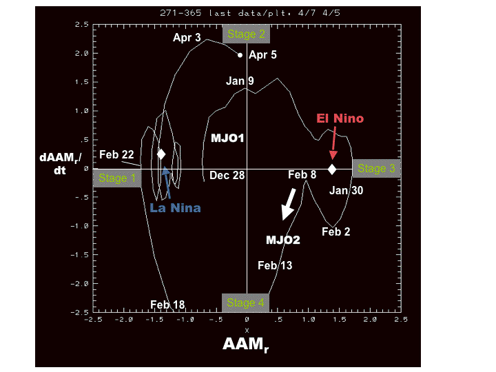
An experimental phase space plot of the GSDM utilizing relative AAM tendency (Y-axis) and relative AAM (X-axis) can be found at
http://www.cdc.noaa.gov/map/images/gcm/gsdm_040507_95d.gif
These are probabilistic statements, which we will try to quantify in future posts. The WB (2007) paper on the GSDM has been published in the February issue of MWR. I will attempt an update this Friday.
Ed Berry
No comments:
Post a Comment