The spatial distribution of global tropical SSTs remains similar to 4/5, the date of my last posting. A horseshoe pattern of weak-moderate warmth centered at roughly 0/155E (anomalies ~.5-1C) continues while total SST of 29-30C extend from near the Philippines into the South Pacific. Recent surface westerly wind anomalies have disrupted the cooling along the equatorial cold tongue east of 150W. SSTs remain above average across most of the Indian Ocean, with totals around 29-30C, as well as the tropical Atlantic.
There is not much change in my thinking from the 4/5 posting. Global relative atmosphere angular momentum (AAM) is now weakly above average. The recent strong positive AAM tendency of ~40 Hadleys did more to overcome strong zonal mean easterly wind anomalies than actually contributing to zonal mean westerly wind flow anomalies. However, there have been other dynamical feed-back processes tied to past Rossby wave energy dispersions from west central Pacific tropical forcing. Also, AAM transports linked to the synoptic eddies have led to a zonal mean flux convergence of westerly momentum at around 35N. A response has been for strong zonal mean westerly wind anomalies; for example, ~10m/s at 200mb from 30-40N. A very strong positive global mountain torque (with contributions from east Asia and North America) of more than 40 Hadleys as of 4/8 per reanalysis data plots is helping to maintain the strong midlatitude westerly flow. I think the latter is part of a global mountain-frictional torque index cycle, one of the components of the GSDM. The above would offer some attribution to the current strong and baroclinically active extended jet extending from South Asia into the central USA.
The main highlight about the tropical convective forcing is the increase observed over the warm Indian Ocean SSTs during the past 5-7 days. Animations of upper tropospheric daily mean vector wind totals and anomalies suggest jet streak dynamics with the anomalous subtropical twin cyclones ~100E are helping to initiate this convection. In fact, water vapor satellite imagery shows westerly flow from this Indian Ocean convection interacting with the strong North Pacific jet. Other enhanced convection remains across the west central Pacific and portions of tropical Africa and South America.
Velocity potential fields and multivariate EOF tools such as the Wheeler phase space plot clearly show a Western Hemisphere dynamical signal. Upper tropospheric vector wind animations also present a signal of Western Hemisphere anomalous twin subtropical anticyclones. This signal is already starting to return into the Eastern Hemisphere, and I think it will do so weeks 2-3. My probabilistic thought would be to see a consolidation of the tropical forcing ~60-120E during this time and possibly project onto a MJO. Even if the latter does not occur (yet), those with global interests should be concerned about heavy rainfall from the Indian Ocean into possibly the west central Pacific weeks 2-3. Furthermore, there may be an increased risk of tropical cyclones across the Bay of Bengal and perhaps portions of the west Pacific during this time.
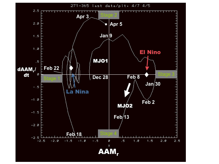
I think GSDM Stage 3 best describes the weather-climate situation, but only as a faster variation within a low AAM base state since mid-February. In fact, an experimental phase space plot of relative AAM tendency (Y-axis) and relative AAM (X-axis) at
http://www.cdc.noaa.gov/map/images/gcm/gsdm_040507_95d.gif
supports this notion.
I think AAM tendency will become negative “soon” followed by a decrease of AAM. I would expect ~GSDM Stage 4 by week 2 followed by Stage 1 afterwards. As most models are showing, this means a very active pattern for most of the USA week 1. This emphasis should shift west and north weeks 2-3. However, many week-2 ensemble means suggest a trough to also linger along the east coast, which is reasonable given shorter wavelengths. This does not bode well for enhanced west coast upwelling.
Please note: These are probabilistic statements, which we will try to quantify in future posts. The WB (2007) paper on the GSDM has been published in the February issue of MWR. I will attempt a brief update this Friday.
Ed Berry
No comments:
Post a Comment