“The views expressed are those of the author and do not necessarily represent those of the National Weather Service.”
As I typed on 23 May, I will not be able to do my next discussion until the weekend of 5-7 June. In general, postings will be difficult this summer due to travel, covering shifts, etc.. This is all the more reason why our effort needs to be mainstreamed asap. Please email me/leave comments if you have questions.
Please see links in the 23 May discussion for real-time and other information. An apparently rapid GWO 7-8-1 transition is occurring as I type, and zonal mean westerly wind flow anomalies are strong in the subtropical atmospheres (~plus 5-7m/s at ~15N/250mb). Loosely, a superposition of phase 5 for the MJO and phases 8-1 of the GWO 250mb snr psi composite anomaly plots depicts the current global circulation. I think the wind and convective signals getting back into sync. That coupling is probable to occur in the region of the west Pacific Ocean during the next few weeks, projecting in octants 6-8 of MJO/GWO phase space, which is on the El-Nino side. Having the expected difficulties, most models are starting to capture a USA synoptic evolution days 5-10 fairly consistent with the atmosphere heading toward these GWO/MJO phases.
As the subtropical westerly wind flow anomalies propagate poleward, relative to climatology the North Pacific Ocean jet will strengthen. Perhaps as part of a more robust coupled GWO/MJO 7-8-1 transition, at some point this jet is likely to come into the western states while collapsing, leaving a trough in its wake. This could lead to a very active southwest flow storm track focusing on the central/northern Plains/Upper Mississippi Valley regions ~mid June. Weather impacts, as well as all the issues with unpredictable timing and other details, are understood.
As compared to a year ago, I am now convinced that some form of an El-Nino is more probable going into the 2009-10 boreal cold season. However, the issues raised in past discussions remain valid, and we need to diligently and rigorously monitor. Will the tropical convective forcing signal finally "get out of Dodge (La-Nina)" and start hanging out in the west Pacific beginning this summer? That is, in contrast to the past 2 Northern Hemisphere cold seasons, be displaced toward octants 6-8 of WH (2004) phase space? Stay tuned.
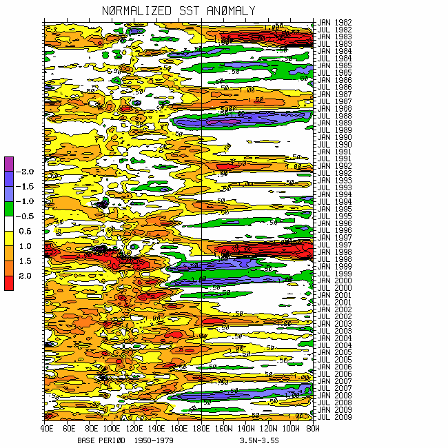
There is little change to the spatial pattern of global SSTs from a week ago. An earlier trade wind surge across the west central Pacific Ocean responding to the MJO did slightly weaken the warm anomalies around the equatorial Dateline. However, the thermocline slope remains less than normal and, loosely, slightly positive SSTs extend along the equator from Indonesia to South America. Warmest ocean waters globally (greater than 30C) continue just east of New Guinea as well as in pockets across the North Indian Ocean including both the Arabian Sea and Bay of Bengal.
One of the many ENSO issues includes the magnitude of (any) additional warming across the west Pacific Ocean during the next several months. In short, if there is to be a respectable El-Nino this upcoming boreal cold season, I am still not impressed by what I am observing. For instance, tropical convective forcing is “hanging back” north of the equator centered on the Bay of Bengal (more said below). There are also too many global circulation La-Nina characteristics that are impossible for me to address here. The atmospheric component of the weather-climate dynamical system may again call the “Nino SST shots” after this summer.Please remember that ENSO is an interannually evolving global phenomenon impacted by interactions across multiple time/space scales (including GWO dynamics/processes), not ONI.See links below.
There is also no change to the painful complexity, including the harsh reality that now is not a good time to be making weather predictions. Tropical convective forcing remains most intense across the Eastern Hemisphere. However, there are now arguably 2 regions, one centered in the Bay of Bengal (BB; including a tropical cyclone attempting to develop) and the other ~0/155E.The MJO component, as a continuation from the April event, is still propagating eastward ~10-12m/s leading to the west Pacific Ocean flare-up. The enhanced rainfall centered on the BB was left in the wake of the MJO, and is likely contributing to the onset of the regional-scale monsoon systems. All things considered, in addition to the possibility of the return of the nemesis of 2 convective regions discussed in the past, I am also concerned the quasi-stationary La-Nina tropical signal may be attempting a comeback. Again, the global financial markets are a great analogy. Just like we are still in a major bear stock market with economic issues will take some time to resolve, in terms of AAM the atmosphere still has significant bearish signals.Perhaps it is time to “short” the recent global AAM rally!
The combination of the winds and convective signals has led to a resurgent MJO signal in WH (2004) phase space, having ~1.5 sigma projection in octant 7 (through 22 May) and somewhat weaker in octant 6 retaining ENSO. The “loop scenario” offered in my 16 May discussion worked out.Phase 6 of the 250mb MJO snr psi composite anomaly plots best describes tropical and even a few extratropical circulation anomalies. My thought has been for this signal to persist in octants 6-8 for a while. However, there may start to be cancellation between the 2 regions mentioned above. Regardless of the projection, I still do expect a signal of tropical forcing to propagate through the Western Hemisphere during the next few weeks. Stay tuned as the mixed signals mess continues.
Tropical-extratropical interactions including the MJO and dynamical processes explained by the WB (2009) measure of the GWO have worked to create a recent respectable positive global wind tendency. Through 21 May global AAM tendency was ~plus 20 Hadleys having large zonal mean contributions from the equatorial and subtropical atmospheres. In fact, latest 250mb weekly means are ~3-4m/s.However, albeit shifted northward, 250mb weekly averaged zonal mean easterly wind flow anomalies are ~10m/s around 45-50N, strongly bearish.
Forced by AAM transports (see plots), those poleward and downward propagating anomalous zonal mean easterly wind flows have increased global and zonal mean mountain and frictional torques during the past 7-10 days. That has also contributed to the recent increase in global westerly wind flow with relative AAM near the R1 data climatology. The point from this untangling of the earth-atmosphere AAM budget is that there is finally a greater than 1 sigma projection of the GWO. Through 21 May the signal was in octant 4-5 of phase space. However, I am not at all confident there will be the nice GWO variations in the near future like observed during this past boreal cold season. There may be a weak orbit towards octants 7-8-1; however, hanging around toward phases 3-5 UFN appears probable (weak La-Nina). Phase 4 of the GWO 250mb snr psi composite anomaly plot reasonably describes the current global atmosphere.
Synoptic responses during the past week or so included the zonal mean storm track shifted anomalously poleward over the Northern Hemisphere, continuation of anomalous extratropical ridges (both hemispheres) with low pressure across the subtropics, and Western Hemisphere subtropical jets. Cutting to the chase, I do expect the latter to shift poleward and bring the Northern Hemisphere storm track southward (including the lower 48 states) over the next 2-3 weeks. During roughly days 10-20 a couple of strong progressive troughs across the western into the central states (north of ~35-40 degrees) is still possible should there be some form of GWO 7-8-1 transition. Maybe there is still some hope for project VORTEX!
I am continuing the notion I have had since mid-April about the average synoptic pattern across the USA during JJA.This is as depicted by roughly a superposition of GWO/MJO phases 3-5 (weak La-Nina atmosphere) of the 250mb snr psi composite anomaly plots centered on 15 July. As previously typed, that is suggestive of ridges near both coasts with some form of a trough in the middle of the country ~85-90W. Of course, a bit more global westerly wind flow and this pattern could be the reverse! Weather impacts, nationally and internationally should be understood from the composites.
Appendix
All presentations from the 24 February 2009 GWO workshop are available via anonymous ftp. If you have not received information on how to retrieve these, let me know. There was excellent attendance at this day-long event, and feedback was strongly positive. We are working HARD to mainstream this effort. The support is very much appreciated!
Links to CPC and PSD ENSO discussions, and a new experimental forecast technique involving a coupled LIM (3rd link below):
These are probabilistic statements. We hope that an opportunity will arise for us (soon) to allow our dedicated web page effort to mature, expediting objectively and accountability. This web page effort will hopefully include an objective predictive scheme for the GWO with hindcasts.
The WB (2007) paper on the GSDM has been published in the February issue of MWR. The first of a two-part paper, where WB formally introduce the GWO (WB (2009)), is (still) awaiting publication in MWR. An early on-line release can be downloaded from the following link:
In addition to the subseasonal snr composite anomaly plots, we would like near real-time discussions with “weather maps” to become a routine part of the ESRL/PSD GSDM web site sometime soon. Part-2 of our GWO paper will discuss the latter. We want to emphasize notions such as global-zonal mean-regional scale linkages as well as forcing-response-feedback (with subsequent interactions) relationships. An important purpose is to provide a dynamical weather-climate linkage framework to evaluate the numerical models in a sophisticated manner as part of a complete subseasonal (and any time scale) forecast process, in addition to a climate service for all users. Relying on the numerical models alone is a cookbook, extremely unscientific, and makes Rex the Rottweiler VERY angry! I will not be able to do a complete discussion until the weekend of 5-7 June.Anyway, I need a break from all this atmospheric madness!
Very intense tropical convection has substantially cooled total and anomalous SSTs ~1-2C across the equatorial and North Indian Ocean during the past week. Consistent with the seasonal cycle, the 29-30C isotherm has expanded north into much of the Arabian Sea and Bay of Bengal. Interactions with the extratropics have forced well below normal waters centered on the South China Sea (SCS) and the Philippines. SST anomaly magnitudes across the SCS are ~minus 2C with totals less than 28C, not good news for regional monsoon onset.
Finally, for the first time in at least 2-3 years weak (less than 1C) positive anomalies extend all along the equatorial Pacific Ocean basin from ~140E to the coast of South America, with the 29C isotherm still west of the Dateline on the equator. Latest 5-day averaged TAO buoy data continues to show a less than average thermocline slope, and ~plus 1-3C anomalies at depth as a function of the latter. Is there an ENSO signal here especially given the recent stochastic Hell? Stay tuned, and see links below.
There is no change to the weather-climate dynamical system involving mixed complicated signals. This is one reason for the relatively weak projections in both the WH (2004) MJO and WB (2009) GWO phase spaces (keeping in mind the details of these measures). Hence the confidence of any subseasonal and longer predictions must be inherently low.
Tropical convective forcing with the MJO did erupt across the Indian Ocean during the last 5-7 days. However, as I expected given the history of this event (see past discussions), the equatorial signal is propagating east very quickly, ~15-20m/s per my own “back of the envelope” calculations. Supportive of the latter is the projection onto convectively coupled Kelvin waves per coherent modes Hovmollers. Full disk satellite imagery suggests there is some consolidation occurring ~120E north of the equator. For reasons that I will only briefly discuss in the following, I think we may be looking at another behavior of tropical forcing having some similarities to this past March-April.
The atmospheric circulation has been drifting back toward La-Nina during the past couple of weeks ("over bought" atmosphere?), related to the tropical forcing but also involving GWO processes as defined in WB (2009). Total (not relative) AAM has dipped to ~1 sigma below the R1 data climatology (through 14 May), with significant contributions coming from the subtropical atmospheres of both hemispheres dominated by anomalous zonal mean easterly wind flows. In fact, latest weekly averages of these anomalous easterlies at 250mb have been greater than 5m/s. Furthermore, there is once again interhemispheric meridional symmetry of zonal mean zonal wind anomalies favoring strong midlatitude ridges. Even though the global signal is weak (competing terms in the AAM budget), phase 3 of the GWO 250mb psi composite anomaly plots reasonably depicts the current tropospheric circulation.
The astute readers will notice that the distribution of zonal mean relative AAM anomalies is similar to early-mid March, including the equatorial positive signal (cyclonic shear in the subtropics). There are also some similarities with the other terms, including the frictional torque and the transports (see plots). A notable difference to me is that there are no anomalous upper tropospheric subtropical troughs in the region of the Dateline. In fact, I could suggest that these troughs have been displaced into the east Pacific with anticyclones around the Dateline/west Pacific Ocean. In other words, the possibility exists that the ENSO background state in the tropics has been shifted east, perhaps as the result of the past 2 stochastically (GWO) driven MJOs. Interestingly, the Australian jet has been anomalously strong the past 1-2 weeks. Are we seeing a forcing-response-feedback loop, and is this the “hard reality” of ENSO transition, should that be the case?
Regardless, my point is I think it is probable the tropical forcing will get established ~0/140E during the next couple of weeks, then perhaps also continue east as a MJO into the Western Hemisphere. The WH (2004) MJO projection may do a “loop inside the magic 1-sigma circle of death”, then come out and "hang around" in octants 7-8 for a while. Remembering that the WB (2009) measure of the GWO is a global dynamical quantity tied to ENSO, its projection may remain relatively weak until the interannual component of the weather-climate system clarifies.
The global circulation may behave as shown by phases 3-5 of the GWO 250mb psi composite anomaly plots during the next couple of weeks. Weeks 3-4 may see a loose GWO/MJO superposition of phases 6-8. At some point during early-mid June a form of at least GWO 7-8-1 transition may be probable. Until we can show maps having several variables with verifiable probabilities, this forecast information will continue to be confusing to many users.
For the USA, with variations that suggests troughs off/around the west coast and the region of the eastern states, with anomalous ridging west of the Mississippi River the rest of this month. Anomalous low pressure in the Gulf of Mexico including the possibility of a hybrid tropical cyclone (Anna?; SSTs are marginal, refer to official forecasts) combined with the above may give the Plains some respite from severe local storms at times. During the first couple weeks of June strong progressive troughs may again shift into the western and central states poleward of ~35-40N. That may (again, very low confidence) lead to the situation I discussed in my 9 May posting.
Appendix
All presentations from the 24 February 2009 GWO workshop are available via anonymous ftp. If you have not received information on how to retrieve these, let me know. There was excellent attendance at this day-long event, and feedback was strongly positive. We are working to mainstream this effort. The support is very much appreciated!
Links to CPC and PSD ENSO discussions, and a new experimental forecast technique involving a coupled LIM (3rd link below):
These are probabilistic statements. We hope that an opportunity will arise for us (soon) to allow our dedicated web page effort to mature, expediting objectively and accountability. This web page effort will hopefully include an objective predictive scheme for the GWO with hindcasts.
The WB (2007) paper on the GSDM has been published in the February issue of MWR. The first of a two-part paper, where WB formally introduce the GWO (WB (2009)), is (still) awaiting publication in MWR. An early on-line release can be downloaded from the following link:
In addition to the subseasonal snr composite anomaly plots, we would like near real-time discussions with “weather maps” to become a routine part of the ESRL/PSD GSDM web site sometime soon. Part-2 of our GWO paper will discuss the latter. We want to emphasize notions such as global-zonal mean-regional scale linkages as well as forcing-response-feedback (with subsequent interactions) relationships. An important purpose is to provide a dynamical weather-climate linkage framework to evaluate the numerical models in a sophisticated manner as part of a complete subseasonal (and any time scale) forecast process, in addition to a climate service for all users. Relying on the numerical models alone is a cookbook, extremely unscientific, and makes Rex the Rottweiler VERY angry! I am planning on posting a discussion next weekend, 22-24 May.
Please see links below for global SST details. The largest expanse of warmest ocean waters globally persist across the equatorial and North Indian Ocean, with totals in excess of 30C and anomalies ~plus 1-2C. As is typical prior to monsoon onset, the 30C SST isotherm has been expanding northward into both the Bay of Bengal and Arabian Sea. There has also been warming of the equatorial west central Pacific Ocean, with totals ~30C and roughly plus 1C anomalies.
In general, slightly positive SST anomalies cover the equatorial Pacific Ocean basin and the slope of the thermocline continues to decrease. Anomalous surface westerly wind flows linked to the ongoing MJO has contributed to this evolution. However, for numerous reasons the ENSO situation is unclear and diligent monitoring must continue. For example, if coherent dynamics start to “heat” the equatorial west Pacific substantially during boreal summer into autumn, then I will get impressed about the possibility of transitioning to a warm event. Regardless, subseasonal activity (GWO/MJO, etc.) will continue, and these will impact North America.
While the general behavior of our weather-climate situation continues to evolve as expected during the past several weeks, many details have become more complicated than I would like. I do think I see “what is going on”; however, I have typed that before and drawn the wrath of Rex the Rottweiler! Somewhat analogous to rolling a backup bowling ball and relying on that to get a Brooklyn strike, I feel my poor USA assessment a week ago for this upcoming week (western USA trough for a period of days) was partly linked to “playing the MJO card” while not being conscientious enough about its initiation. That is, stochastic GWO dynamics forced its initiation during early-mid March around Indonesia (see past discussions), and that forcing appears to have been “taketh away”. This once again demonstrates to me and should also to the rest of the world that it is important to keep in mind the on-going dynamics, and to know better than “play a signal” regardless of its origins (for example). The latter are serious basic research issues, and there is no way I can do justice about those matters here.
WH (2004) plots updated through 7 May show a greater than 1 sigma projection in octant 7 (west Pacific Ocean) of phase space, having done a loop from a week ago. I was expecting phase 8 then 1. In reality, there is no “loop” in the atmosphere. The trace is an artifact of this empirical technique. Animations of upper tropospheric daily mean vector wind anomalies show a well-defined subtropical wave train (SWT) propagating through the Eastern Hemisphere ~30N forced by interactions with the extratropics (sound familiar?). That has disrupted the MJO signal, and the dynamics do involve the WB (2009) measure of the GWO. For example, tied to the SWT (a zonally oriented RWD typical of a GWO response), anomalous upper tropospheric twin anticyclones are returning to Africa and the western Indian Ocean. In other words, and consistent with the past 2008-09 boreal cold season, I offer that the GWO is again driving the MJO. It is clear to me that the extratropics are currently forcing the tropics. Could this kind of behavior be telling us something about where ENSO is going?
Full disk satellite imagery and other tools show that the global signal of tropical convective forcing is somewhat disorganized. However, cutting to the chase, the African Highlands/Gulf of Guinea regions are active, there is Indian Ocean “sputtering” and a convectively coupled Rossby mode is over western Indonesia. It is probable there will be some form of consolidation over much of the Indian Ocean during the next 1-2 weeks. The west Pacific Ocean (loosely) is also somewhat active, and that region may again become a “wild card” UFN (recall our "nemesis"). During weeks 2-3, enhanced rainfall should further consolidate/shift into the region of Indonesia, and the Eastern Hemisphere monsoon systems may also be active at that time. It is uncertain whether or not a “REAL” MJO will initiate during the next several weeks.
As expected, the GWO projection in phase space is improving located in octants 8-1 through 7 May. It is at this point where I can only “hope” readers can start to put things together (need maps!). Tied to the SWT interacting with the MJO signal, etc., a strong negative global friction-clustered mountain torque index cycle is in progress as I type. The latter is contributing to a decent negative global AAM tendency (~20 Hadleys relative to R1 data climatology) with much of the zonal mean contribution coming from the subtropical atmospheres. Stated another way, several circulation features characteristic of La-Nina are returning. A response is that our strong North Pacific Ocean jet is collapsing, one of the reasons all numerical models have been performing poorly (along with me!) for about the past week. Other behaviors include above average easterly wind flows increasing ~25-30N/35S, zonal mean storm tracks shifting anomalously poleward at least across the Northern Hemisphere, and ridges starting to dominate the extratropics.
Summing up so far, could our “May surprise” be a re-emergence of stationary tropical forcing across the Eastern Hemisphere favoring an eventual return to La-Nina? Or, will we finally see the initiation of decent coherent MJOs that could significantly impact the equatorial Pacific? These are only 2 of an infinite number monitoring issues, and stay tuned. I wanted to make a bit of an effort to get readers to gain an even better appreciation of some of the serious real-time scientific matters that are currently (and always) involved spanning wide time and space scales. This is an example of the next level of weather-climate research/monitoring that is needed, and hopefully that will come to fruition via the ESRL/PSD GSDM web page.
As I typed last week, a GWO/MJO 8-1-2 transition is in progress (WH “loop” understood). The 250mb GWO snr psi composite anomaly plot for phase 1 reasonably depicts the current global circulation. One can also argue a loose superposition of MJO phases 1-2 with GWO phase 1. Per above, with reasonable confidence (I hope!), I offer that a superposition of phases 2-3 for both the GWO and MJO 250mb snr plots for psi and other variables is plausible through at least week-2. For the USA, this suggests our familiar synoptic pattern of progressive western and central states troughs increasing the risk of severe local storms across the central and northern Plains/Upper Mississippi Valley. Possible weather globally can also be inferred from the composites, in addition to the expertise of the international centers. There has been some recent increase of global high impact weather.
Afterward, and I think some readers will understand why, I do have some concern (low confidence) that heading into June, with perhaps many episodes through August, that a synoptic pattern typical of ~GWO phase 4 may occur. That is, per 250mb snr psi composite anomaly plots centered ~15 July, USA west and east coast ridges with troughs across the central states into the Great Lakes at times are possible. While there may be periods of cool and wet for the Plains and Great Lakes states, episodes of intense heat may occur particularly west of the Continental Divide.
Appendix
All presentations from the 24 February 2009 GWO workshop are available via anonymous ftp. If you have not received information on how to retrieve these, let me know. There was excellent attendance at this day-long event, and feedback was strongly positive. We are working to mainstream this effort. The support is very much appreciated!
Links to CPC and PSD ENSO discussions, and a new experimental forecast technique involving a coupled LIM (3rd link below):
These are probabilistic statements. We hope that an opportunity will arise for us (soon) to allow our dedicated web page effort to mature, expediting objectively and accountability. This web page effort will hopefully include an objective predictive scheme for the GWO with hindcasts.
The WB (2007) paper on the GSDM has been published in the February issue of MWR. The first of a two-part paper, where WB formally introduce the GWO (WB (2009)), is (still) awaiting publication in MWR. An early on-line release can be downloaded from the following link:
In addition to the subseasonal snr composite anomaly plots, we would like near real-time discussions with “weather maps” to become a routine part of the ESRL/PSD GSDM web site sometime soon. Part-2 of our GWO paper will discuss the latter. We want to emphasize notions such as global-zonal mean-regional scale linkages as well as forcing-response-feedback (with subsequent interactions) relationships. An important purpose is to provide a dynamical weather-climate linkage framework to evaluate the numerical models in a sophisticated manner as part of a complete subseasonal (and any time scale) forecast process, in addition to a climate service for all users. Relying on the numerical models alone is a cookbook, extremely unscientific, and makes Rex the Rottweiler VERY angry! I am planning on posting a discussion next weekend, 15-17 May.
Please see links below for global SST details.Partially linked to the seasonal cycle, the warmest SSTs globally are across the equatorial Indian Ocean, with totals in excess of 30C and anomalies ~plus 1-2C. Exceptionally strong convective suppression during at least the past couple of weeks has also contributed to these warm waters. SST anomalies across all Nino regions are loosely slightly positive. Recent surface westerly wind anomalies have assisted with this warming.However, the 29C isotherm is still west of the Dateline on the equator. Regardless of whatever viewpoint anyone chooses, scientifically, the future course of ENSO (global ocean-land-atmosphere dynamical system perspective) is unclear.Historically, weather-climate events (surprises?) during May can provide some insight.
Per WH (2004) measure and other tools, the moist convective signal with the ongoing strong MJO is propagating through the Western Hemisphere as I type. Updated through 1 May there is still well over a 2 sigma projection in octant 7 of WH (2004) phase space. Broadly, during the last couple of weeks numerical models have tended to weaken this signal too quickly and have been too slow with the eastward propagation. A large contribution to the MJO projection has been the Indian Ocean suppression mentioned above.
Moist tropical convective forcing has already propagated poleward off the equator across the west central Pacific, increasing the tropical cyclone hazard in the region of the Philippines. The accompanying surface westerly wind flow anomalies are also shifting away from the equator into the both hemispheres along and west of the Dateline. Meanwhile, moist convection is increasing from Central and South America into equatorial Africa.There is some “sputtering” along the east Pacific Ocean ITCZ, and working with the extratropics, a relatively moist subtropical jet (STJ) is directed toward the southern USA states assisting with rainfall production. The latter is consistent with phase 7 of the MJO, which is an EL-Nino like circulation response per WB (2009) GWO phase space. However, cutting to the chase, there are still non-trivial La-Nina characteristics to the global circulation, and the above mentioned STJ is rather “pathetic”.
There continues to be the lack of a significant projection in phase space of the WB (2009) measure of the GWO (since ~1 April). Recall (again) that the GWO is a global dynamical measure of the atmosphere, whereas the WH (2004) empirical MJO measure only considers lower and upper tropospheric winds with OLR anomalies within 15 degrees of the equator. From the global perspective, there has been a weakening La-Nina allowing relative AAM to return to about normal per R1 data climatology. In fact, through 30 April relative tropospheric AAM is slightly above normal. Additionally, AAM tendencies have not been large (for reasons), all combining to give the appearance of a weak GWO signal.
However, zonal mean and regional scale GWO components, as well as individual terms of the earth-atmosphere AAM budget have been anything but weak. These include Eastern Hemisphere subtropical wave trains that excited the 2 (stochastically forced "cheap") MJOs in the region of Indonesia during the past 4-5 months, and roughly 20-30 day variations of the global mountain torque. Through 30 April the global frictional torque has dipped to below minus 10 Hadleys largely from frictional dissipation of recently added westerly wind flow. That is the lowest since about mid-January. The frictional dissipation has not only occurred in portions of the tropics/subtropics (tied to the MJO), but also across the extratropical storm track regions. My suspicion is there may be a large negative AAM tendency during the next couple of weeks (more said below). Is it time to “short the atmosphere”?
Regardless of details, a superposition of phase 7 for both the GWO and MJO snr 250mb psi composite anomaly plots best depicts the current global circulation. For example, there has been subtropical transition of Eastern Hemisphere upper tropospheric circulation anomalies, and a “poor excuse” of an extended north Pacific Ocean jet has occurred. These behaviors were expected per past discussions.
It is relatively clear to me that a GWO/MJO 7-8-1-2 transition is in progress (a.k.a. a low to high zonal eddy wave number transition response across the Northern Hemisphere extratropics). The corresponding snr 250mb psi composite anomaly plots should depict the expected synoptic behavior of the atmospheric circulation over the next few weeks.The probable response for other variables such as anomalous 2m air temperature across North America can also be determined from the composites (we hope to add more variables).This evolution should go through its life cycle by roughly later week-2/week-3. Numerical models already have been, and will continue to struggle (in addition to seasonal transition issues).
Enhanced moist tropical convective forcing is likely to return to the Eastern Hemisphere including the Indian Ocean/Indonesian regions during weeks 2-3. However, uncertainty issues include persistence, and whether or not the MJO signal will continue. In any case, it is during this period that AAM tendency may become strongly negative contributing to a strengthening projection of the GWO perhaps in octants 2-3 (back toward La-Nina) of phase space by week-3. Disciplined serious daily weather-climate (WB (2007) GSDM sense) monitoring is critical UFN to gain a better understanding of the course of any additional subseasonal activity and possible ENSOramifications. Using models as a stand alone is anything but scientifically complete and defensible.Synoptically for the USA, other than being about a week later, there is little change from what I typed in my 24 April posting.
Appendix
All presentations from the 24 February 2009 GWO workshop are available via anonymous ftp. If you have not received information on how to retrieve these, let me know. There was excellent attendance at this day-long event, and feedback was strongly positive. We are working to mainstream this effort. The support is very much appreciated!
Links to CPC and PSD ENSO discussions, and a new experimental forecast technique involving a coupled LIM (3rd link below):
These are probabilistic statements. We hope that an opportunity will arise for us (soon) to allow our dedicated web page effort to mature, expediting objectively and accountability. This web page effort will hopefully include an objective predictive scheme for the GWO with hindcasts.
The WB (2007) paper on the GSDM has been published in the February issue of MWR. The first of a two-part paper, where WB formally introduce the GWO (WB (2009)), is (still) awaiting publication in MWR. An early on-line release can be downloaded from the following link:
In addition to the subseasonal snr composite anomaly plots, we would like near real-time discussions with “weather maps” to become a routine part of the ESRL/PSD GSDM web site sometime soon. Part-2 of our GWO paper will discuss the latter. We want to emphasize notions such as global-zonal mean-regional scale linkages as well as forcing-response-feedback (with subsequent interactions) relationships. An important purpose is to provide a dynamical weather-climate linkage framework to evaluate the numerical models in a sophisticated manner as part of a complete subseasonal (and any time scale) forecast process, in addition to a climate service for all users. Relying on the numerical models alone is a cookbook, extremely unscientific, and makes Rex the Rottweiler VERY angry! I am planning on posting a discussion next weekend, 8-10 May.