Global tropical SSTs remain above average with exceptions of coolness around Indonesia and more importantly the equatorial east Pacific. Magnitudes are ~0.5-1.5 C. Subsurface anomalies as low as minus 4.0C exist down to about 100m at 140W per TAO buoy array data with cool anomalies down to about 200m at the equatorial date line. Total SSTs are generally near or above 30C across the Indian Ocean and from the west central-South Pacific. It is still unclear whether or not a La-Nina is developing since May is a seasonally critical month.
Tropical convective forcing is getting better organized ~90-120E. Monitoring tools including the Wheeler phase space plot suggest a MJO may be developing in that region. The latter has been discussed as a possibility in recent posts. Other clusters of intense tropical thunderstorm activity remain across the South Pacific and equatorial Africa. A convectively coupled Kelvin wave, possibly forced by the extratropics a week ago, is supporting the activity across Africa. This forcing may contribute to additional enhanced rainfall across the equatorial Indian Ocean into Indonesia week 1. Whether or not a coherent eastward shift of tropical convection occurs across the Eastern Hemisphere afterwards remains to be seen. However, those with interests in that region should be concerned about excessive rainfall and possibly Bay of Bengal tropical cyclone development for at least weeks 1-2.
GSDM Stage 0.5 still best describes the current-weather climate situation. An evolution to ~ Stage 1.5 may occur during the next few weeks particularly if a MJO develops. Zonal mean easterly wind flow anomalies of ~5m/s loosely exist across the equatorial and subtropical atmospheres with magnitudes as high as 10m/s around 25N. Global relative AAM tendency is still weakly negative while actual AAM is a good 1 standard deviation below the R1 climatology as of April 25th (~1.5 sigma including the stratosphere presumably due to the easterly QBO phase). There are also indications of flux convergence of AAM ~40-50N in the presence of a developing sink across the northern subtropics. In fact, this flux convergence of AAM transport has been shifting northward during the last couple of weeks, probably related to the seasonal cycle.
Much of the USA (the CONUS has generally been my focus in these postings) has been through a very active period this past week. After a brief respite, this situation is probable to return. Particularly with the week-2 ensemble means from various operational centers, there is a lot of model spread in regard to the locations of troughs, ridges, possible so-called omega blocking north of the Great Lakes, etc., etc., etc.. These are the situations where an understanding of the weather-climate situation from rigorous daily monitoring utilizing tools such as the GSDM is needed to make an intelligent evaluation of all other numerical, statistical, etc., tools to formulate week 1-2 (week 1-4?) predictions. I view this procedure as a complete forecast process to provide the best possible information to sophisticated users.
Probablistically, more deep troughs and closed lows in the Rockies are likely by week 2 (pattern shifting slowly north). These lows should eject northeast into the mid and upper Mississippi Valley having the kind of impacts (warm sector severe thunderstorms and snowstorms across the Rockies) already observed for the past several weeks. Heavy rainfall and strong storms may start across the Southern Plains by early next week with the remnants of a subtropical jet. By week 2 the Rockies and Plains should experience exceptionally active May weather. I do think a blocking GSDM Stage 1 USA pattern is a possibility for week 2. Other ramifications may include excessive warmth across the Deep South with cool conditions across the Northeast. This situation should slowly shift east week 3.
Appendix
An experimental phase space plot of the GSDM utilizing normalized relative AAM tendency (Y-axis) and normalized relative AAM (X-axis) can be found at
http://www.cdc.noaa.gov/map/images/gcm/gsdm_95d.jpg
These are probabilistic statements, which we will try to quantify in future posts. The WB (2007) paper on the GSDM has been published in the February issue of MWR. I will try to write an update sometime next week while on travel.
Ed Berry
Friday, April 27, 2007
Monday, April 23, 2007
Stage 0.5 Update
There is no change to the discussion I issued on 4/20. Upper tropospheric zonal mean easterly wind flow anomalies are increasing throughout the tropical and subtropical atmospheres with much of that coming from the Eastern Hemisphere. In fact, anomalous twin subtropical anticyclones are becoming quite robust from Africa into Indonesia. Global relative atmospheric angular momentum (AAM) tendency remains at ~minus 20 Hadleys as of April 21st per reanalyis data (R1) with actual AAM about 1 standard deviation below the 1968-1997 R1 climatology.
We expect the tropical convective forcing to further respond to these wind signals starting this week and especially week 2. Anomalous rainfall should become noticeable from the equatorial Indian Ocean to Indonesia from ~80-120E while the South Pacific forcing weakens. Full-disk satellite imagery supports this trend. Whether or not this convection shifts east as a MJO afterwards is unclear. However, the multivariate Wheeler phase space plot suggests a MJO projection may be developing across the Indian Ocean. It is possible this convection may just persist in that region of the Eastern Hemisphere.
Our interpretation is GSDM Stage 0.5 best describes the global weather-climate situation (see link below). We think the global circulation will be in ~Stage 1.5 by the end of week 2. Signals are mixed whether or not a La-Nina is developing, and May is a critical transition month.
As discussed on 4/20, equatorial westerlies currently across the East Pacific will contribute to another North Pacific jet extension by early next week (which many ensembles do show) and then slam the western USA with more strong troughs starting later week 2. Thus after the current active period for much of the USA ends, there should be a respite. However, exceptionally active May weather looks probable later week 2 into possibly week 4 (shifted slightly north from April). Most readers should know the ramifications of strong mobile western states troughs and a southwest flow storm track on the Plains during May. For instance, several rounds of severe local storms on the Plains, late season snowstorms across the Rockies and summertime heat across the Deep South are probable.
Appendix
An experimental phase space plot of the GSDM utilizing normalized relative AAM tendency (Y-axis) and normalized relative AAM (X-axis) can be found at
http://www.cdc.noaa.gov/map/images/gcm/gsdm_95d.jpg
These are probabilistic statements, and work is ongoing to quantify in future posts. The WB (2007) paper on the GSDM has been published in the February issue of MWR. I will try to write an update by Thursday or Friday this week. I am on lots of travel and have to cover operational shifts.
Ed Berry
Friday, April 20, 2007
Orbiting in GSDM Phase Space
Shift work obligations and upcoming travel for at least the next 2 weeks will impact the timeliness and completeness of these discussions, including this writing. However, my thinking from 4/17 remains unchanged. Zonal mean anomalous upper tropospheric easterly wind flow continues to increase throughout the tropical and subtropical atmospheres. Magnitudes are ~5m/s contributing to a negative global relative atmospheric angular momentum (AAM) tendency of about minus 15 Hadleys as of 4/18. Twin upper tropospheric subtropical anticyclones are becoming better established over the Eastern Hemisphere and actual relative AAM is approaching 1 standard deviation below the 1968-1997 NCEP/NCAR reanalysis climatology.
A fairly large region of enhanced tropical convective forcing extends from eastern Indonesia into the South Pacific. This rainfall has been locally forced by warm SSTs and interactions with the extratropics. Upper tropospheric Western Hemisphere westerly wind flow anomalies across the Pacific have been a response, and have contributed to the southern USA subtropical jet. This region of tropical convection is slowly moving east-southeast enhancing the South Pacific Convergence Zone (SPCZ). Meanwhile, monitoring tools suggest a struggling dynamical signal from the equatorial Atlantic into the Indian Ocean.
I think the global circulation remains in GSDM Stage 4, and it now appears probable to me it will stay roughly in that phase plane until the above mentioned dynamical signal becomes robust. In fact, the trajectory shown on the referenced plot in the Appendix may do ~1-2 circles before we finally get a MJO sometime in May. My feeling is those equatorial westerlies discussed above will contribute to another extended North Pacific jet by week 2 (which many ensembles have picked up) and then slam the western USA with more strong troughs by weeks 3-4. Thus after an active week 1 for much of the USA, week 2 should be relatively tranquil followed by exceptionally active May weather weeks 3-4 (shifted slightly north from April). Most readers should know the ramifications of strong mobile western states troughs and a southwest flow storm track on the Plains during May. For instance, several rounds of severe local storms on the Plains, late season snowstorms across the Rockies and summertime heat across the Deep South would be probable.
Appendix
An experimental phase space plot of the GSDM utilizing normalized relative AAM tendency (Y-axis) and normalized relative AAM (X-axis) can be found at
http://www.cdc.noaa.gov/map/images/gcm/gsdm_95d.jpg
These are probabilistic statements, which we will try to quantify in future posts. The WB (2007) paper on the GSDM has been published in the February issue of MWR. I should be able to write an update by late next week.
Ed Berry
Tuesday, April 17, 2007
GSDM Stage 4
A horseshoe pattern of slightly warmer than normal SSTs (~.5-1.0C) still extends from the far west Pacific into the subtropical date line regions. Globally, the only significant but weak cool anomalies are those along the equatorial east Pacific east of ~150W. However, subsurface magnitudes as low as minus 4C remain down to depths of around 200m and will need to be monitored for the possibility of La-Nina. Large expanses of 29C and warmer total SST cover much of the Indian Ocean and from around Indonesia into the South Pacific.
Since the weak MJO during February and the large negative tendency of relative AAM of ~minus 40 Hadleys around the middle of that month, weather-climate signals have been difficult to diagnose. However, forced by warm west Pacific SSTs and interactions with the extratropics, intense flare-ups of tropical convection have occurred ~every 10-20 days. The envelope of this forcing loosely shifted east from ~120E on about March 19th to 160W by around April 2nd. At least 2 well-defined Rossby wave energy dispersions linked to this forcing arced across the North American and Atlantic extratropics into Asia. These resulted in strong positive global mountain torques (in excess of 30 Hadleys) with a large contribution from East Asia. A response was for large upper tropospheric zonal mean westerly wind anomalies across the northern subtropical atmosphere with magnitudes greater than 10m/s. This occurred from a combination of poleward propagating zonal mean westerly wind flow anomalies off the equator forced by the convection and the positive mountain torques.
Regionally, 4 intensifications of the East Asia jet into the North Pacific occurred since late February. However, the strongest (anomalies in excess of 30m/s) were just after March 20th and about a week ago, directly linked to the strong East Asia mountain torque. The latter is actually a faster component of the GSDM we term as a mountain-frictional torque index cycle, where surface friction works to remove atmospheric westerly flow (global frictional torque currently around minus 10 Hadleys). These jet intensifications have contributed to periods of extremely stormy and high-impact weather across much of the USA.
I think all of the above is a situation where the atmosphere is exhibiting fairly rapid subseasonal variations while dynamically working to maintain a slowly evolving La-Nina base state. We are now at the point where the SSTs and the extratropics are leading to a reorganization of the tropical forcing across the Eastern Hemisphere. Specifically, per animations of upper tropospheric wind fields anomalous twin anticyclones are developing ~120-140E as a response to the strong convection while a weak dynamical signal remains around Africa. It is unclear how strong the latter will become. However, anomalous zonal mean easterly flow is developing across the subtropical atmospheres and global relative AAM tendency is again strongly negative as are the mountain and frictional torques.
I think we are solidly in GSDM Stage 4. Tropical convective forcing currently extends from the Indian Ocean into the west Pacific, just south of the equator. Other pockets of are also across equatorial Africa and South America (with twin anticyclones). My feeling is for the tropical convection to get better organized and consolidated from Africa into the Indian Ocean roughly by the end of week 2, while other SST forced convection remains across the west Pacific. Later week 2 into week 3, the dynamical signal discussed above may project onto a MJO.
With good initial condition information, most ensembles show an exceptionally active storm track with several western USA troughs/closed lows through at least day 10. Not discussed above is the possibility of our GSDM Stage 4 situation being nearly stationary for ~1-2 weeks (not favorable for west coast upwelling) before evolving into Stage 1. In any case, I offer that this active pattern (above climatology) may persist well into May, weeks 3-4. Thus locations such as the Plains States may have several rounds of severe thunderstorms while the Northern Rockies and Northern Plains experience late season snowstorms.
Appendix
An experimental phase space plot of the GSDM utilizing relative AAM tendency (Y-axis) and relative AAM (X-axis) can be found at
http://www.cdc.noaa.gov/map/images/gcm/gsdm_040507_95d.gif
These are probabilistic statements, which we will try to quantify in future posts. The WB (2007) paper on the GSDM has been published in the February issue of MWR. I will attempt an update this Friday.
Ed Berry
Friday, April 13, 2007
Snowed In
My next posting will be delayed to about next Tuesday (4/17) thanks to complications caused by a (thunder) snowstorm attributable to our GSDM Stage 3-4 regime. My thinking from the 4/11 posting remains unchanged. Tropical convective forcing is getting better organized across the Eastern Hemisphere including central Africa, the equatorial Indian Ocean ~80E and the west Pacific ~150E. We will need to monitor where this forcing consolidates. My suspicion is from ~60-120E during week 2, then possibly shift east as a MJO. I think the circulation will evolve into GSDM Stage 4 by week 2 then Stage 1 afterwards. An exceptionally active regime emphasizing the Rockies and Plains weeks 1-3 is probable. This may include several rounds of severe thunderstorms across the Plains later week 2 - week 3.
Ed Berry
Ed Berry
Wednesday, April 11, 2007
Rebirth of the MJO revisited
The spatial distribution of global tropical SSTs remains similar to 4/5, the date of my last posting. A horseshoe pattern of weak-moderate warmth centered at roughly 0/155E (anomalies ~.5-1C) continues while total SST of 29-30C extend from near the Philippines into the South Pacific. Recent surface westerly wind anomalies have disrupted the cooling along the equatorial cold tongue east of 150W. SSTs remain above average across most of the Indian Ocean, with totals around 29-30C, as well as the tropical Atlantic.
There is not much change in my thinking from the 4/5 posting. Global relative atmosphere angular momentum (AAM) is now weakly above average. The recent strong positive AAM tendency of ~40 Hadleys did more to overcome strong zonal mean easterly wind anomalies than actually contributing to zonal mean westerly wind flow anomalies. However, there have been other dynamical feed-back processes tied to past Rossby wave energy dispersions from west central Pacific tropical forcing. Also, AAM transports linked to the synoptic eddies have led to a zonal mean flux convergence of westerly momentum at around 35N. A response has been for strong zonal mean westerly wind anomalies; for example, ~10m/s at 200mb from 30-40N. A very strong positive global mountain torque (with contributions from east Asia and North America) of more than 40 Hadleys as of 4/8 per reanalysis data plots is helping to maintain the strong midlatitude westerly flow. I think the latter is part of a global mountain-frictional torque index cycle, one of the components of the GSDM. The above would offer some attribution to the current strong and baroclinically active extended jet extending from South Asia into the central USA.
The main highlight about the tropical convective forcing is the increase observed over the warm Indian Ocean SSTs during the past 5-7 days. Animations of upper tropospheric daily mean vector wind totals and anomalies suggest jet streak dynamics with the anomalous subtropical twin cyclones ~100E are helping to initiate this convection. In fact, water vapor satellite imagery shows westerly flow from this Indian Ocean convection interacting with the strong North Pacific jet. Other enhanced convection remains across the west central Pacific and portions of tropical Africa and South America.
Velocity potential fields and multivariate EOF tools such as the Wheeler phase space plot clearly show a Western Hemisphere dynamical signal. Upper tropospheric vector wind animations also present a signal of Western Hemisphere anomalous twin subtropical anticyclones. This signal is already starting to return into the Eastern Hemisphere, and I think it will do so weeks 2-3. My probabilistic thought would be to see a consolidation of the tropical forcing ~60-120E during this time and possibly project onto a MJO. Even if the latter does not occur (yet), those with global interests should be concerned about heavy rainfall from the Indian Ocean into possibly the west central Pacific weeks 2-3. Furthermore, there may be an increased risk of tropical cyclones across the Bay of Bengal and perhaps portions of the west Pacific during this time.
I think GSDM Stage 3 best describes the weather-climate situation, but only as a faster variation within a low AAM base state since mid-February. In fact, an experimental phase space plot of relative AAM tendency (Y-axis) and relative AAM (X-axis) at
http://www.cdc.noaa.gov/map/images/gcm/gsdm_040507_95d.gif
supports this notion.
I think AAM tendency will become negative “soon” followed by a decrease of AAM. I would expect ~GSDM Stage 4 by week 2 followed by Stage 1 afterwards. As most models are showing, this means a very active pattern for most of the USA week 1. This emphasis should shift west and north weeks 2-3. However, many week-2 ensemble means suggest a trough to also linger along the east coast, which is reasonable given shorter wavelengths. This does not bode well for enhanced west coast upwelling.
Please note: These are probabilistic statements, which we will try to quantify in future posts. The WB (2007) paper on the GSDM has been published in the February issue of MWR. I will attempt a brief update this Friday.
Ed Berry
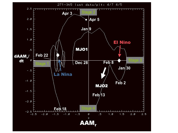
Thursday, April 05, 2007
Rebirth of the MJO?
The most robust signal of global tropical SSTs are the cool anomalies east of about 150W along the equatorial cold tongue, with magnitudes as low as minus 3C. Negative anomalies of at least minus 4C remain down to ~200m extending to about the date line. The positive SST anomalies across the west central and South Pacific have cooled significantly during the past week due to recent intense rainfall and tropical cyclone activity. Anomaly magnitudes are only ~.5C with totals ~28-29C. Similar SSTs also exist across the equatorial Atlantic Ocean, and the equatorial Indian Ocean remains quite warm with SSTs ~29-30C. It is still unclear to me if the coupled ocean-atmosphere (and other processes) system is evolving toward La-Nina since May is a critical month.
The weather-climate situation remains very complicated meaning most (not all) signals are weak. Careful daily monitoring within the GSDM framework is a must for any week 1-4 predictions. Short course is the extended North Pacific jet of roughly 2 weeks ago contributed to an eastward shift of the most intense tropical convection from ~120E to 160E in a period of about a week. This forcing has since weakened with only “pockets” of convection hanging around central-eastern Indonesia into the central Pacific, northern South America, west central Africa and the central Indian Ocean. The latter is a component of the slow westward drift of the tropical forcing from the South Pacific which started around mid-January.
The most robust signals remain the global relative atmospheric angular momentum (AAM) and its tendency, keeping in mind the zonal mean contributions. Animations of upper tropospheric winds during the last week-10 days present some rapid but interesting behaviors. As the tropical forcing moved into the west central Pacific Rossby wave energy dispersion led to ridge amplification along the USA west coast and a deep central North American trough. Additionally, weak upper tropospheric zonal mean westerly wind anomalies (~5m/s or less at 200mb) have developed throughout the tropical and subtropical atmospheres, while exhibiting poleward propagation. The dynamics responsible for these processes have resulted in a global AAM daily mean positive tendency of ~40 Hadleys on April 2nd (reanalysis plots are 5-day averages). The magnitude of this tendency is roughly equal to the negative event observed back in mid-February.
Does this mean we have had a GSDM Stage 2 response and are headed for Stage 3, or are we seeing a perturbation in a slowly evolving GSDM Stage 1 base state possibly linked to a developing La-Nina? I continue to advocate the latter. While there is likely to be a “spike” in global relative AAM during the next few days (how much is unclear), that is all I think it will be. Several diagnostics including velocity potential and even the multivariate EOF Wheeler phase space plot tell me there is a developing dynamical signal across the Western Hemisphere. I think this signal will come back into the Eastern Hemisphere and it is probable that MJO tropical convection will appear across the warm Indian Ocean sometime week 2-3. This would argue for another negative AAM tendency and an overall persistence of a low AAM GSDM Stage 1 regime.
As most ensembles are capturing, another extended North Pacific jet episode is highly probable starting this weekend leading to strong troughs that will first slam into the USA west coast. This situation is likely to weaken coastal upwelling along the California coast, at least in the short-term. These troughs are then likely to move into the Rockies and Plains. This means the April cold regime now affecting the Upper Mississippi Valley into the Northeast should moderate early next week. Going well into next week and possibly through week 3, much of the lower 48 states may be in for an exceptionally stormy regime, centered on the Rockies and Plains. In fact, understanding the seasonal cycle, events similar to the period of the last couple of weeks of December 2006 and the last half of February 2007 may be probable.
Please note: These are probabilistic statements, which we will try to quantify in future posts. I continue to have travel. It is likely I will not be able to do another posting until around 4/11. The WB (2007) paper on the GSDM has been published in the February issue of MWR.
Ed Berry
Subscribe to:
Posts (Atom)