Sea surface temperatures anomalies (SSTA) throughout much of the global tropics are generally less than 2C with warmth across the Indian Ocean and west central Pacific Ocean and coolness along the East Pacific equatorial cold tongue. Totals across the former are ~29-30C. At depth negative anomalies less than minus 3C remain ~140W/100m per latest TAO buoy data. Interestingly, the largest anomalies and warmest SSTs as of 23 July per CPC data are present across much of the Tropical Northwest Pacific (TNWP) from west of the date line to the South China Sea. Anomalies are in excess of 2C with totals 30-31C. The latter is part of the horseshoe spatial distribution of warm SSTAs across the west Pacific Ocean into the extratropics.
Most numerical and statistical forecast tools continue to suggest La-Nina conditions (ocean forcing-circulation response, etc.) to be probable through at least boreal fall. As I stated a week ago, my own feelings are the coolest anomalies will remain across the East Pacific and this will not be a basin wide situation. The positive SST anomalies across the west Pacific warm pool are deep and have been persistent for at least the past 5-7 years.
Full disk satellite imagery have presented a nice signal of expanding tropical convection centered ~80-90E on the equator for the past several days. Latest 3-day averaged OLRA are ~minus 50-90W/m**2. This region of very intense tropical rainfall has been surging northward into India and southern China (tied to both the monsoon and severe thunderstorm frontal band activity) during the last few days. Meanwhile, strong suppression has been present from the west central Pacific into the Philippines, allowing the SSTs to warm across those regions. Satellite imagery as of this writing shows tropical forcing expanding along the equator to at least 150E, with a contribution coming from a convectively coupled Kelvin wave. These satellite, OLR and signals from numerous other diagnostic tools (a few discussed below) tell us a MJO is in the early stages of developing. In fact, this may be the strongest MJO signal since the December 2006-January 2007 event.
Over the last week this enlarging region of Eastern Hemisphere tropical convective forcing has started to slowly move east along the equator. Accounting for the Kelvin wave, I computed a phase speed of roughly 5m/s (4 deg long/day). However, there have been too many events of recent tropical forcing that shift east quickly, then stall, etc. How this latest situation will behave is still unclear (more said below). Statistical tools such as the multivariate Wheeler and Hendon (2004) technique currently suggest a strong MJO projection of ~2 standard deviations. While not unreasonable, these and other similar techniques from various global operational weather centers tend to both lose the signal and eastward motion after about a week.
There is some recent research (Jiang et. al. 2007) which suggests a “predictability barrier” exists for MJO evolution as the moist convection emerges from Africa into the Indian Ocean. It is possible we are currently seeing this impact. However, my own thoughts to all of this are: 1) predictability of this MJO should start to improve; and 2) I think it is probable for very intense convective forcing to shift into Southeast Asia while extending through the TNWP during the next few weeks.
The global circulation is dynamically responding. Animations of fields such as operational data upper tropospheric daily mean vector wind anomalies suggests a reversal in wind patterns across the tropical atmosphere during the last week or so. Twin anticyclones are developing across the western Indian Ocean ~60E with downstream lows ~120E. Additionally, the twin tropical/subtropical anticylones that were ~140E roughly 10 days ago have been displaced poleward into the central Pacific Ocean of both hemispheres. I hope this will be a “good thing” for the western USA during the next few weeks. However, feedback processes from the extratropics are still supporting Rossby wave energy dispersions across the North Pacific that is maintaining the wicked western USA ridge.
Zonal mean easterly wind flow anomalies are strengthening throughout the subtropics particularly around 15N, where magnitudes of ~5-10m/s at 200mb are now present. The equatorward propagation of zonal mean zonal wind anomaly bands discussed last week appears to have ceased. In the lower levels there is a trade wind surge along the equator with anomalies ~5-10m/s west of the date line as a response. How far east this trade surge spreads along the equator may be important for additional La-Nina development.
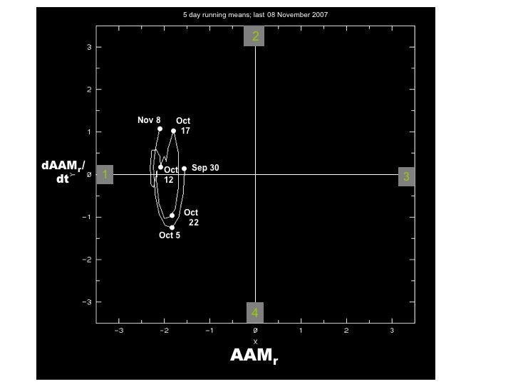
ESRL/PSD R1 data AAM plots updated through 21 July do not (yet) present strong torque and transport signals. The global frictional and mountain torques are slightly negative with the largest contribution to the latter coming from East Asia (~minus 10 Hadleys). A negative East Asian mountain torque, meaning below normal mean sea level pressures along the east slopes of the topography, is probable as MJO convection organizes across the Indian Ocean. The global AAM tendency is close to minus 20 Hadleys with actual AAM (including the QBO) ~minus 1.5 standard deviations. Updated through 15 July (5-day average), the Global Wind Oscillation (GWO) clearly suggests GSDM Stage 4-1.
Before going into the forecast, I want to make some comments about this summer’s western USA ridge from Hell. First, I have done a very poor job (in my view) with predicting the magnitude and extent of the anomalies (unprecedented excessive heat, drought, etc.) associated with it. During the last several weeks I have offered this ridge would shift off the USA west coast, and that has only occurred maybe once or twice for very brief periods. While this option may have been the "right" forecast, the atmosphere choose to take a different path given its stochastic nature. One of the premises of numerical ensemble weather prediction is to offer these alternate trajectories through phase space since it is a dynamical systems approach. An interesting study in itself would be to see how many, if any, ensemble members captured this alternate evolution.
In retrospect, I am not surprised by the magnitude of the ridge. In fact, there were comments made in past Blog postings during the late spring expressing concerns over a western USA ridge this summer. However, I did not think the situation would get as bad as it has. A message from all of this is the need for us to express subseasonal predictive information making use of probability shifts while having a complete forecast process including the GSDM and the numerical models. Any lesser effort is not scientifically and practically fair.
There has been past modeling work that suggests summer western USA drought patterns with a warm and convectively active Indian Ocean (~GSDM Stage 1). The trend for anomalously intense ridges to be shifted northwest from climatology across western North America during summer has been an unfortunate occurrence during roughly last 5 years. Again, to make better use of, and intelligent evaluation, of any numerical model output a diagnostic weather-climate linkage framework such as the GSDM is needed to allow attribution efforts as presented here. The information learned will translate to better subseasonal forecasts.
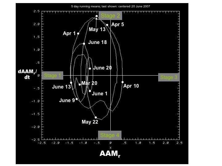
Uncertainty remains very high and my confidence is in the toilet for any week 1-4 prediction. That said, I am not changing my forecast reasoning from a week ago. It still looks on track, which is “something”. As discussed above, I think we have a MJO dynamical signal, and tropical forcing spreading into the TNWP weeks 2-3 is probable. The South Asian monsoon system still represents a stationary component forcing the global circulation. The GWO should undergo a slow decent orbit through GSDM Stage 1 and possibly Stage 2 by week 3. Of course, other faster variations are likely to contribute to smaller quasi-phase space circuits, and the GWO amplitude due to the MJO is unclear. However, similar to large variations seen from March-May 2007, the orbits are probable to be tilted toward GSDM Stage 1. For the PNA sector I think this will translate to a “net” retrogression of the western North American ridge to possibly ~140W by week 3. After all, I am bound to get this “right” eventually. Deliberately continuing to beat a dead bull, the truth of the matter is this effort needs to be properly supported to allow expression of these predictions probabilistically, with appropriate and fair verification.
International ramifications include locations from the Indian Ocean into Southeast Asia and southern China getting repeatedly pounded with severe thunderstorms and flooding rainfall. Areas that have been hit hard during much of this summer are likely not to see much relief for at least weeks 1-2. In fact, I would not rule out tropical cyclone activity for the Arabian Sea week 1 and Bay of Bengal week 2. Rainfall should slowly increase from west to east across Indonesia weeks 1-2. The current suppression across the TNWP should give way to active convection weeks 2-3. This includes tropical cyclone activity perhaps threatening the Philippines and Japan. Finally, the environment for tropical cyclone development across the Atlantic Ocean basin looks to be more favorable later week 1 and week 2.
Impacts across the global extratropics include the continuation of the parade of intense storm systems hammering much of Europe and more strong troughs for western and southwestern South America, weeks 1 and 2. The latter is the Southern Hemisphere analog to western North American troughs during boreal winter GSDM Stage 1 situations.
For the USA, we still have to deal with predictability issues caused by the shorter wavelengths, existing zonal mean and circulation anomalies from past “events”, and seasonal cycle matters going into August. Week-two ensemble means from various centers are starting to exhibit more disagreement; no surprise given the above. The ESRL/PSD ensemble mean actually shows a spatial distribution of 500mb geopotential height anomalies consistent with the proposed retrogression scenario favoring a central USA trough. Other models do not support this notion very well. Quoting from my 17 July posting, “In fact, more consistent with GSDM Stage 1 and possibly Stage 2 working with the seasonal cycle heading into August, the ridge may shift into the east Pacific Ocean (~140W) leading to trough development across the Rockies and western Plains with a Southeast states ridge. This may allow some reversal of the temperature and precipitation anomalies seen for the past several weeks”. Hey, at least I am being consistent!
Appendix
An experimental quasi-phase space plot of the GSDM utilizing a time series of normalized relative AAM tendency anomaly (Y-axis) and normalized relative AAM anomaly time series (X-axis) can be found at
http://www.cdc.noaa.gov/map/images/gcm/gsdm_95d.jpg
http://www.cdc.noaa.gov/map/images/gcm/gsdm_40d.jpg
We call the behavior of this plot the Global Wind Oscillation (GWO), and one of its purposes is to extend thinking beyond the MJO.
These are probabilistic statements, and work is ongoing to quantify in future posts. We hope that an opportunity will arise for us to have a dedicated web page effort to expedite more objectively, with rigor, thoroughness and verification. The WB (2007) paper on the GSDM has been published in the February issue of MWR. I will try to at least briefly update this Blog on Friday (27 July). In general, due to covering shifts and travel, my postings will be irregular through at least August.
Ed Berry
Tuesday, July 24, 2007

Friday, July 20, 2007
Tune in Early Next Week
Due to a having to perform a civic duty today, my next posting will not be until around next Tuesday. My thoughts from the 7/17 discussion remain reasonable.
Full disk satellite imagery shows tropical convective forcing slowly organizing across the Indian Ocean centered ~5S/80E while extending through the Bay of Bengal into China. If indeed we do have a real MJO organizing, we think it is in the early stages. The global circulation remains in GSDM Stage 1 as shown by the Global Wind Oscillation (GWO). Just like a mystery movie, tune in early next week as I attempt to offer reasonable insight into what may be a critical subseasonal period concerning weather-climate linkage.
Appendix
An experimental quasi-phase space plot of the GSDM utilizing a time series of normalized relative AAM tendency anomaly (Y-axis) and normalized relative AAM anomaly time series (X-axis) can be found at
http://www.cdc.noaa.gov/map/images/gcm/gsdm_95d.jpg
http://www.cdc.noaa.gov/map/images/gcm/gsdm_40d.jpg
We call the behavior of this plot the Global Wind Oscillation (GWO), and one of its purposes is to extend thinking beyond the MJO.
These are probabilistic statements, and work is ongoing to quantify in future posts. We hope that an opportunity will arise for us to have a dedicated web page effort to expedite more objectively, with rigor and thoroughness. The WB (2007) paper on the GSDM has been published in the February issue of MWR. I will try to update this Blog next week around Tuesday (7/24). In general, due to covering shifts and travel, my postings on this Blog will be irregular through at least August.
Ed Berry
Tuesday, July 17, 2007
Will there be Synchronicity (Blog from Hell!)?
Eastern Hemisphere equatorial SSTs remain above average across the Indian and west central Pacific Oceans with magnitudes ~1-2C and totals around 29-30C. There has been cooling along the Pacific Ocean cool tongue east of ~160W during the last week. Anomalies vary from ~minus 0.5 to at least minus 2C with the coldest west of South America. At depth negative anomalies lower than minus 4C is present ~140W/100m per latest 5-day averaged TAO buoy data through 16 July. These at depth negative anomalies were generated when the East Pacific oceanic thermocline was raised by the strong trade wind surge nearly a month ago. In response to increasing tropical convection across the Eastern Hemisphere (discussed below), surface easterlies are increasing west of the equatorial date line which may contribute to another trade wind surge farther east. This dynamic process may upwell the colder water to the surface and intensify La-Nina.
Whatever the case, and as shown by most numerical and statistical forecast tools, La-Nina conditions (ocean forcing-circulation response, etc.) are probable through at least boreal fall. My own feelings are the coolest anomalies will remain across the East Pacific and this will not be a basin wide situation. The positive SST anomalies across the west Pacific warm pool are deep and have been persistent for at least the past 5-7 years. The latter is one of my reasons for the possibility of a decent El-Nino “sometime in the future”.
There is still the horseshoe spatial pattern of anomalous warmth from the west central Pacific Ocean into the extratropics. Per latest CPC data through 14 July totals in excess of 30C were observed at 20N. Warmth also continues from the tropical East Pacific (10-20N) Ocean into the Caribbean while slightly below normal SSTs are generally the rule across the equatorial Atlantic. In fact, totals are only around 27-28C (still warm enough for tropical cyclone development) northeast of South America in contrast to above 30C across the Gulf of Mexico.
Now that we have some understanding of recent SST trends, discussion can move onto tropical convective forcing. Again, it is fundamental to remember that tropical ocean forcing onto the atmosphere is bridged through tropical convection. After the June weak-moderate MJO, a dynamical signal best observed in the upper tropospheric velocity potential field has been propagating through the Western Hemisphere at ~15-20m/s. Even though this signal decoupled from the MJO convection, it remained relatively coherent through dynamic interactions with various feedback anomalies including extratropical processes such as Rossby wave trains. About a week ago there was an intensification of convection (with tropical cyclones) across the East Pacific. Currently the dynamical signal is centered on Africa, and is about to emerge into the India Ocean.
Full disk satellite imagery shows intense equatorial convection centered ~70E having 3-day averaged OLRA ~minus 50-70 W/m**2. In the wake Typhoon Man-Yi, tropical forcing is suppressed from the west central into the northwest Pacific. Hence we are already starting to observe a spatial pattern of equatorial Indian Ocean enhanced rainfall with west central Pacific suppression. There are still large clusters of strong/severe thunderstorms from northern India into Southeast Asia, with another region of suppression across the portions of central India into the Bay of Bengal. In addition to the unusually strong South Asian monsoon system, the current China convection also had a contribution due to northward propagation from the June MJO.
Given how far south the Indian Ocean convection is, I think it is probable another MJO signal is evolving across this region. I feel I can defend this notion based on some of the circulation responses I am seeing. Per animations of ESRL/PSD operational data upper tropospheric daily mean vector wind anomalies there is increasing divergence with developing twin tropical/subtropical anticyclones ~60E with some hint of twin cyclones near the date line. Additionally, weak easterlies are starting to appear locally around Africa and west of South America and even in the zonal mean particularly north of the equator. The R1 data AAM tendency plot (only through 13 July) also supports a weak negative zonal mean tendency around the equator of roughly 1-2 Hadleys.
The global circulation remains painfully complicated to write about particularly in terms of attribution of events during the past month or so. Per Global Wind Oscillation (GWO) phase space plot updated through 11 July (5-day average), 2 circuits have been completed during the past 40 days tilted toward GSDM Stage 1. The physical processes responsible were not only circulation responses from the MJO, but perhaps more importantly from extratropical processes such mountain-frictional torque index cycle variations. Adding to the complexity is there has not only been poleward propagation of zonal mean zonal wind anomalies (already discussed in previous posts), but also equatorward across the Northern Hemisphere.
In a valiant attempt to be brief and understanding the relevant terms of the AAM budget, I think the earlier June orbit had an important contribution from the East Asian mountain torque. I can see evidence of this from the animations (recall the past 2 pairs of twin anticyclones and cyclones), and I think this orographic forcing played a role in initiating equatorward propagation of anomalous zonal mean westerly flow (~10 m/s at 200mb) from the higher latitudes (~60N) into eventually the midlatitudes (~30-40N). In fact, there were also other anomalous zonal mean bands of westerlies and easterlies moving south. I think the second more recent circuit was tied to intensification of the west central Pacific Ocean tropical convection that eventually spun-off Typhoon May-Yi. My point is this equatorward propagating zonal mean anomalous westerly wind flow contributed to the recently observed anomalous North Pacific Jet (~25 m/s anomalies at 250mb per recent weekly mean) that led to the current positive projection onto the Pacific-North American teleconnection (PNA).
Working with shorter wavelengths due to boreal summer, this is actually a regional response to complicated global and zonal mean dynamical tropical-extratropical forcing. What I termed as a “Stage 3 circulation with Stage 1 convection” in my 13 July posting was in terms of this regional response. As I type there is another very strong Rossby wave energy dispersion emanating from the west central Pacific that will amplify the current western states “wicked” ridge. Finally, the synoptic pattern seen across the USA during the last week-10 days has been roughly 10-15 degrees farther east than I thought to be most probable in postings a few weeks ago.
Like a broken record, I once again make it clear that uncertainty is huge for any week 1-4 prediction. I am going with the notion there is another MJO signal developing across the Indian Ocean, and this will augment the South Asian monsoon system during the next few weeks. In fact, there is some statistical support for a MJO coming not only from the Wheeler phase space plot, but also from the plot produced by United Kingdom Meteorological Office. Again, tied to our weak La-Nina, there is a stationary component dynamically forcing the global circulation and the enhanced Eastern Hemisphere monsoon system is a response to that. MJO and other variability that is probable to occur will be superimposed upon this base state. In other words, there will be additional circuits in GWO phase space tilted toward GSDM Stage 1 but whose amplitudes are unclear. As this MJO organizes it should propagate east and northeast similar to the June event.
International ramifications include an intensification of rainfall from the equatorial Indian Ocean into India and much of Indo-China particularly ~week 2. Intense frontal precipitation including severe thunderstorms may extend from this tropical convection into portions of China. Meanwhile the tropical northwest Pacific Ocean should be relatively suppressed at least week 1 only to get quite active by ~week 3. Tropical cyclone concerns are unclear after the week 1 East Pacific activity. Given the warm SSTs across the Gulf of Mexico and the Caribbean, I do have some concerns for a “hybrid system” weeks 2-3 in that region. One source may come from anticyclonically wave breaking lows as the eastern USA trough weakens. Locations such as the Philippines and Japan may see an increasing threat from tropical cyclones weeks 3-4.
Finally, Rossby wave energy dispersion into the austral winter Southern Hemisphere may favor another strong trough for western and southwestern South America later week 1 into week 2. This is the Southern Hemisphere analog to a western North American trough during boreal winter GSDM Stage 1 situations. Hence another possibility exists for an exceptionally cold and wet pattern for locations such as Argentina by week 2.
For the USA, we have to deal with predictability issues caused by the shorter wavelengths and existing zonal mean and circulation anomalies from past “events”. I think the models are reasonable with the slow eastward shift of the anomalous large amplitude trough-ridge-trough pattern week 1. The Pacific Northwest is cooling down and the Great Lakes and eastern states should do the same by this weekend. Afterwards, very warm air is probable to spread back into particularly the Northern Plains and Upper Mississippi Valley. Mainly diurnal thunderstorm activity should persist from the Deep South into the Rockies.
It is during weeks 2-4 (going into mid August) I think our part of the world will feel impacts from the possible MJO and other complicated circulation variations linked to the tropics, etc., as described by the GSDM. Most numerical ensembles show deamplification and progression of the current pattern during week 2. I think this idea is reasonable. However, I am holding the line that whatever synoptic evolution occurs, it is probable there will be a net retrogression of the sick USA synoptic pattern that has featured the “wicked ridge of the west” for about the past week. In fact, more consistent with GSDM Stage 1 and possibly Stage 2 working with the seasonal cycle heading into August, the ridge may shift into the east Pacific Ocean (~140W) leading to trough development across the Rockies and western Plains with a Southeast states ridge. This may allow some reversal of the temperature and precipitation anomalies seen for the past several weeks.
Appendix
An experimental phase space plot of the GSDM (which we call a Global Wind Oscillation (GWO)) utilizing normalized relative AAM time tendency anomaly (Y-axis) and normalized relative AAM anomaly (X-axis) can be found at
http://www.cdc.noaa.gov/map/images/gcm/gsdm_95d.jpg
http://www.cdc.noaa.gov/map/images/gcm/gsdm_40d.jpg
These are probabilistic statements, and work is ongoing to quantify in future posts. We hope that an opportunity will arise for us to have a dedicated web page effort to expedite more objectively, with rigor and thoroughness. The WB (2007) paper on the GSDM has been published in the February issue of MWR. I will try to update this Blog by around Friday. In general, due to covering shifts and travel, my postings on this Blog will be irregular through at least August.
Ed Berry
Friday, July 13, 2007
Friday the 13th Circulation!!!
This posting will be somewhat less detailed. I will try to post a more complete discussion around Tuesday next week.
Our global circulation state is seemingly appropriate for Friday 13th. R1 AAM data plots show a recent negative global tendency of ~20 Hadleys, suggestive of GSDM Stage 1. Without the QBO global relative AAM is ~ near normal with inter hemispheric symmetry of zonal mean zonal wind anomalies. There are zonal mean anomalous westerlies along the equator (~5-7 m/s at 200mb) flanked subtropical easterlies with westerlies then easterlies poleward. Much of the negative global AAM tendency has come from the mountain and frictional torques as well as the transport signal. The latter has been most pronounced in the Southern Hemisphere.
Tropical convective forcing remains quite active from the central Indian Ocean into the west central Pacific, centered ~10N/90E per full disk satellite imagery. An intense band having three-day averaged OLRA ~minus 50-90W/m**2 extends from the far west Pacific to Typhoon Man-Yi which is starting to impact Japan. Meanwhile, there is a weak dynamical signal of tropical forcing moving through the Western Hemisphere centered on the Americas. A loose phase speed calculation gives me ~17m/s, and it does project onto a convectively coupled Kelvin wave. I think this Western Hemisphere signal is a remnant of the recent MJO. A possibility is for this signal to come back into the Eastern Hemisphere during week 2 and re-invigorate convection across Africa into the very warm western equatorial Indian Ocean (SST anomalies 1-2C). In any event, I think it is probable for our stationary tropical forcing tied to the South Asian Monsoon system to persist for at least the next 2-3 weeks as faster components interact with it. This is consistent with our tilt toward weak La-Nina in terms of ocean forcing and Eastern Hemisphere tropical rainfall distributions.
So, all the above makes a good case for the weather-climate situation to be in GSDM Stage 1, right??? Animations of various wind fields including upper tropospheric and surface daily mean vector wind anomalies support an on-going circulation evolution from GSDM Stage 2 to Stage 3. This observation again demonstrates the need to understand the dynamics of forcing-response-feedbacks/subsequent interactions processes within a weather-climate linkage framework as part of any subseasonal prediction effort.
I think we are finally seeing a more “typical” global circulation response to the past extended period of strongly anomalous Western Hemisphere upper tropospheric equatorial westerly wind flow. These westerly wind anomalies are still present, but with magnitudes of ~5m/s in contrast to ~40m/s a couple of weeks ago. The equatorial westerly wind flow anomalies have been slowly propagating poleward and downward, particularly into the Southern Hemisphere. Nevertheless, the current ~5-10m/s surface west wind anomalies across the North Pacific Ocean ~35N are a response to this dynamic process. Remembering how the Wheeler phase space plot is derived (15N-S domain only), it is these kinds of wind anomaly signals which are leading to its greater than 1 standard deviation MJO projection currently across the Western Hemisphere. However, I argue that any real MJO signal is very weak.
There are weakly anomalous upper tropospheric tropical/subtropical cyclones across the Indian Ocean with downstream anticyclones ~140E. Loosely, this is a reversal of Eastern Hemisphere circulation anomalies from a couple of weeks ago. In fact, map plots of the latest daily mean 150mb vector wind anomalies gives a nice signal of Rossby wave energy dispersions (RWDs) from these west central Pacific anticyclones into the extratropics of both hemispheres. The current western USA ridge is directly linked to the RWD arcing across the North Pacific Ocean from the twin anomalous subtropical anticyclones.
Cutting to the chase, as I type the North Pacific Jet is strengthening (for this time of year). The numerical model ensembles have captured this response. Hence the prediction of a trough-ridge-trough pattern west-east across the USA in about a week looks reasonable. However, even for week 1 uncertainty remains huge in regards to position and amplitude. Other predictions from operational centers may be too over confident in their week 1-2 outlooks. After all, why would that not be the case since we are seeing (in a sense) a Stage 3 circulation with Stage 1 tropical convection! My offering for weeks 2-4 would be for a retrogression of this pattern (again) as tropical forcing remains anomalously strong across the Eastern Hemisphere. It is also probable for the tropics and extratropics to become in-sync as the GWO orbits around GSDM Stage 1 during this time.
Global temperature and precipitation anomalies/high impact weather concerns include the following. Locations from India into Southeast Asia are likely to experience recurrent poundings of severe storms and flooding rainfall. In fact, this situation may worsen weeks 2-4. After Typhoon Man-Yi goes by Japan, tropical cyclogenesis looks less favorable through at least week 2 for the northwest Pacific. The East Pacific should be favorable for tropical cyclogenesis week 1 while the tropical Atlantic stays relatively tranquil ~weeks 1-2. The record cold that has been occuring over much of Argentina and Chile should moderate during week 1.
During week 1 the western USA heat is probable to expand into the Northern Plains/Upper Mississippi Valley while the Pacific Northwest gets welcome cooling. Wet conditions are likely to persist across Texas while thunderstorm activity increases across the Rockies. This situation may last through much of week 2, with temperature anomalies then reversing week 3 due to retrogression. Intense/severe MCS activity may focus on the northern/central Plains later week 2 and week 3 as the process of retrogression occurs.
Appendix
An experimental phase space plot of the GSDM (which we call a Global Wind Oscillation (GWO)) utilizing normalized relative AAM time tendency (Y-axis) and normalized relative AAM (X-axis) can be found at
http://www.cdc.noaa.gov/map/images/gcm/gsdm_95d.jpg
http://www.cdc.noaa.gov/map/images/gcm/gsdm_40d.jpg
These are probabilistic statements, and work is ongoing to quantify in future posts. We hope that an opportunity will arise for us to have a dedicated web page effort to expedite more objectively, with rigor and thoroughness. The WB (2007) paper on the GSDM has been published in the February issue of MWR. I hope to post a decent discussion ~Tuesday next week. In general, due to covering shifts and travel, my postings on this Blog will be irregular through at least August.
Ed Berry
Thursday, July 05, 2007
Crossroads Update
There is no change from the information discussed 3 July. This posting is only a very short update.
Tropical convective forcing continues to slowly increase across the warm west central Pacific Ocean centered ~0/145E while the intense rainfall persists with the South Asian Monsoon system. The MJO signal is very weak. Surface westerly winds having anomalies ~5m/s have developed west of the date line on the equator and will provide a source of cyclonic relative vorticity for upcoming TNWP tropical cyclones during the next few weeks.
It is now a case where we have 2 regions of intense Eastern Hemisphere tropical forcing. The enhanced South Asian Monsoon system favors GSDM Stage 1 while the west central-TNWP favors GSDM Stage 2. The latter has been recently dominating and circulation anomalies across the PNA sector are retrograding. However, global AAM tendency is barely positive (through 2 July per R1 data) with a contribution from the global frictional torque which has become weakly negative. Global mountain torque is still positive but decreasing. Thus the GWO is likely looping around on the left-hand (“La-Nina”) side of the phase space plot.
We may see this “tug of war” between the 2 regions of tropical forcing and subsequent circulation interactions the remainder of this summer. Which area will dominate is unclear. At least for the next week or so the central USA cool/wet regime is quite probable. There is another region of strong tropical convection developing southwest of India, and this area may propagate northeast replenishing the intense and severe thunderstorm activity now pounding regions from Pakistan into Southeast Asia. Meanwhile some consolidation of tropical forcing may occur weeks 2-3 as convective clusters shift toward the Asian Mainland from the west central Pacific. This speculation suggests additional retrogression of the ~west coast ridge-central USA trough- Deep South ridge wave train may occur.
Finally, Linear Inverse Modeling (LIM) work, a statistical technique used to predict variations in the ENSO cycle, suggests an evolution toward a well defined La-Nina by the October-December 2007 (3-month mean) period. See
http://www.cdc.noaa.gov/forecast1/IndoPacific.frcst.html
for details. The recent trade wind surge has contributed to a large negative projection onto the optimal initial structure for anomaly growth. It remains to be seen how well this forecast will perform.
Appendix
An experimental phase space plot of the GSDM (which we call a Global Wind Oscillation (GWO)) utilizing normalized relative AAM time tendency (Y-axis) and normalized relative AAM (X-axis) can be found at
http://www.cdc.noaa.gov/map/images/gcm/gsdm_95d.jpg
http://www.cdc.noaa.gov/map/images/gcm/gsdm_40d.jpg
These are probabilistic statements, and work is ongoing to quantify in future posts. We hope that an opportunity will arise for us to have a dedicated web page effort to expedite more objectively. The WB (2007) paper on the GSDM has been published in the February issue of MWR. It is likely I will not be able to post another discussion until early the week of 16 July due to travel. However, please check. In general, due to covering shifts and travel, my postings on this Blog will be irregular through at least August.
Ed Berry
Tuesday, July 03, 2007
Crossroads
Global equatorial SSTs (per CPC) are generally above average with the exception of weak cool anomalies (~minus 1C) west of South America. The warmest waters with totals of ~29-31C are still present from the west central into the Northwest Pacific Ocean extending to 25 deg. N latitude. Totals across the Indian Ocean are ~29C while the tropical Atlantic Ocean has warmed to roughly 28C. The spatial horseshoe pattern of anomalous warmth continues to emanate out of the west central Pacific into the extratropics of both of hemispheres, with magnitudes in excess of 2 deg C across the Tropical Northwest Pacific (TNWP).
East of the date line along the equator, latest 5-day averaged TAO buoy data shows respectable negative anomalies at depths of approximately 100-250m, with ~minus 5C at about 150m/150W. This is an imprint from the trade wind surge of a couple of weeks ago when the oceanic thermocline was lifted. Weak warm anomalies remain just above that cool layer, and it is unclear whether or not these cool anomalies will surface. Whatever the case, for now, a tilt toward weak La-Nina conditions with respect to the interactions between the tropical oceans and circulation responses for the next 1-3 months is probable.
Tropical convective forcing has increased significantly along the equatorial west central Pacific Ocean during the last few days, with OLRA ~minus 50 W/m**2 centered ~140-150E. The MJO discussed in past writings has contributed to this increase. However, as will be discussed, I think we are losing our MJO signal. Tied to a much stronger than normal South Asian monsoon system, other intense areas of rainfall remains from the northern Arabian Sea into Southeast Asia centered ~15N. In fact, there has been a rapid increase of convection southwest of India that is probable to move north and contribute to additional flooding and other related hazards for that region. Finally, there has been a reasonably coherent convectively coupled Kelvin wave moving through the Western Hemisphere during the last week or so. I think this Kelvin wave may have contributed to the recent Andes Mountain torque of ~20 Hadleys and may also be adding to the local increase of thunderstorm activity across both the African Highlands and the Southwest Indian Ocean. Overall, one can state that the dominate region of tropical convective forcing is across the Eastern Hemisphere extending from the region of Pakistan east-southeast into the west central Pacific Ocean.
So, does the above sufficiently describe current situation of tropical convective forcing? I do not think so. I am leaning toward the notion of an emerging stationary pattern of enhanced tropical rainfall having 2 regions (as discussed in previous posts): the South Asian monsoon system and the TNWP. I think we are going to be hard pressed to see any real coherent MJOs the rest of this boreal summer. Yes, there will likely be more convectively coupled Kelvin waves bleeding into the Western Hemisphere enhancing rainfall around the Americas at times. The current flare-up of west central Pacific tropical convection is likely to shift northwest during the next 1-3 weeks, and a few tropical cyclones are probable as this occurs. There are already weak surface westerly wind anomalies along and just north of the equator in this region, with anomalous twin upper tropospheric subtropical anticyclones developing.
The global circulation response is complicated. It is only from detailed daily monitoring within the GSDM framework I think I can make some sense of it. I do want to be brief describing it. From the animations of fields such as ESRL/PSD 150mb and 250mb daily mean vector wind anomalies and totals during the last several weeks, anomalous upper tropospheric westerly wind flow of ~15-25m/s still persists across the Western Hemisphere. The largest magnitudes of these westerly anomalies are from the date line to South America, with weekly mean anomalies in excess of 25m/s. There are 2 pairs of subtropical anticylones and cyclones not only linked to the tropical forcing discussed above, but also from extratropical feedbacks. One pair of anticylones (cyclones) is ~40-60E (~80E) with the other ~140-150E (just east of the date line). Interacting with the extratropics, Rossby wave energy dispersions from the Indian Ocean (west central Pacific) pair have led to the observed strong ridges across the North Pacific (North Atlantic) during the last couple of weeks. Both of these regions of forcing, with a wet Indian Ocean and a dry west Pacific, have contributed to the intense North America ridge.
These complex interactions have allowed propagation of the well above average equatorial zonal mean upper tropospheric westerly wind flow into the subtropical and extratropical atmospheres, particularly the Southern Hemisphere given austral winter. In fact, during the last week very intense storm track activity has occurred from Australia into the South Pacific. Other ramifications has included an anomalously intense North Atlantic Jet (NAJ) with daily mean anomalies ~40m/s at times. This NAJ has contributed to the recent storminess much of the United Kingdom has experienced. Finally, the added westerly flow has also intensified the jet across southern Asia, which is now interacting with the intensifying tropical convection across the west central Pacific. It is probable that the latter will lead to a retrogression of the North American ridge possibly into the east Pacific during the next few weeks.
Including the contribution from the current easterly phase of the stratospheric Quasi-Biennial Oscillation (QBO), global relative AAM through 30 June per R1 data was slightly below normal, while just above climatology without the QBO. AAM tendency was roughly plus 20 Hadleys with a global mountain torque of ~15 Hadleys giving some contribution. With reduced trades and increased zonal mean surface westerly flow tied to intensified storm track activity across both hemispheres, global frictional torque was near average.
Summing up, I see the intensification of the west central Pacific tropical convection as a major development. This is helping to maintain some of the anomalous upper tropospheric zonal mean westerly wind flow anomalies, hence the recent positive AAM tendency. The Global Wind Oscillation (GWO) is orbiting toward GSDM Stage 2, and I would agree the current weather-climate situation is best described by that Stage. Given 10-30 day mountain-frictional torque index cycles (not discussed today) and the likelihood of additional Western Hemisphere convectively coupled Kelvin waves, a GWO circuit (magnitude unclear) through Stages 3-4 then 1 is a possibility during the next 1-3 weeks. However, I think a stationary to slowly evolving component of the global circulation will dominate until further notice. Additionally, as we go into boreal fall and the South Asian monsoon systems shut down, unlike fall 2006 when the Indian Ocean forcing was the strongest, the west central Pacific Ocean tropical convective forcing may start to dominate given the anomalous expanse and depth of the warm pool ocean water. That may start an evolution to El-Nino at some point. However, I want to emphasize that uncertainty remains huge, not only for the possibility of El-Nino development, but even the subseasonal predictions I am offering today.
There is little change from my previous 2 discussions to the international ramifications of the current weather-climate situation. Tropical cyclone risks will remain for the Bay of Bengal and even the Arabian Sea for at least the next couple of weeks. The west central and TNWP is already starting to fester with development, and could become a major concern by weeks 2-3 possibly threatening Japan ~week 3. Kelvin waves may periodically excite the East Pacific and even the Atlantic at times. In fact, there is currently an area of disturbed weather about 1500 miles east of Windward Islands per TPC that could become a depression during the next day or so. While drought persists across western Indonesia, severe thunderstorms and flooding rainfall are likely to rake areas from Pakistan into Southeast Asia and China.
The discontinuous retrogression of the North American Ridge into possibly the East Pacific Ocean (~140W) by week 3 should bring some relief from the intense heat across the Interior West. More and more ensemble prediction schemes from various global operational centers are catching on to this notion. However, much of that region particularly west of the Continental Divide looks generally dry. The Northern Plains into the Great Lakes are likely to see increasing intense to possibly severe MCS activity starting early next week. Some of this thunderstorm activity may spread southward during week 2 with trough development across roughly the Plains. For locations around Texas, slow relief from the recent flooding rainfall should occur starting next week, maybe sooner. However, for anywhere across the Plains between the Front Range of the Rockies and Mississippi River, severe flooding rainfall events could occur almost “anytime” given the persistent above average moisture transport through the Gulf of Mexico. Temperatures are most probable to tilt toward near-below normal across the middle of country with above normal summertime heat across the Deep Southeast.
Appendix
An experimental phase space plot of the GSDM (which we call a Global Wind Oscillation (GWO)) utilizing normalized relative AAM time tendency (Y-axis) and normalized relative AAM (X-axis) can be found at
http://www.cdc.noaa.gov/map/images/gcm/gsdm_95d.jpg
These are probabilistic statements, and work is ongoing to quantify in future posts. We hope that an opportunity will arise for us to have a dedicated web page effort to expedite more objectively. The WB (2007) paper on the GSDM has been published in the February issue of MWR. I may not be able to post another discussion until late next week or early on the following week due to travel. Please check. In general, due to covering shifts and travel, my postings on this Blog will be irregular through at least August.
Ed Berry
Friday, June 29, 2007
Let's Focus on the Weather
At the time of this writing, ESRL/PSD AAM R1 plots contain data through 26 June and the GWO only through 25 June.
I wish I could answer all questions from recent emails. However, until we have a properly supported dedicated web page effort allowing a focus on efforts such as weather-climate linkage research and subseasonal forecasting; my timeliness to help folks will be significantly impacted. There have been numerous recent extreme weather events globally including across the USA (Texas floods, western heat, etc.), and it is unfortunate that improved predictive information cannot be provided to users who need to make weather sensitive decisions. I want (tried!) to make the following relatively short; including not repeating the issues discussed 26 June.
Global SSTs remain similar to earlier this week. Subsurface anomalies along the equatorial Pacific have cooled to ~minus 4C at ~160W/100m. However, these remain detached from the surface and are the result of the thermocline being raised by the recent anomalously strong (~10m/s) trade wind surge. The tropical west central and northwest Pacific (TNWP) SST totals remain ~29-31C, with a horseshoe pattern of positive anomalies extending into at least the subtropics of both hemispheres.
The main show of tropical convective forcing remains across the Eastern Hemisphere centered ~15-20N/100-110E while extending from the far northern Arabian Sea east-southeast into the extreme TWNP. At least one weak tropical cyclone developed across the Bay of Bengal (BB) during this week while Yemyin ravaged portions of Pakistan (WMO news). The envelope of this tropical forcing has been shifting east-northeast for the last couple of weeks, having an eastward component of ~3-4m/s. I think this is a weak MJO signal, and I also think this will increase tropical thunderstorm activity across portions of the TNWP during the next couple of weeks. In fact, full disk satellite imagery does present a signal of increasing tropical convection from around the Philippines to just west of the date line. There has also been a slight increase in convection over the tropical East Pacific while flare-ups remain along the western equatorial Indian Ocean. The former is tied to a convectively coupled Kelvin wave while the latter is linked to the South Asian Monsoon system.
GSDM Stage 1 still best describes the weather-climate situation. Animations of upper tropospheric daily mean vector wind anomalies through 28 June (FNL data) shows subtropical twin anticyclones ~120E with downstream twin cyclones just east of the date line while stationary twin anticyclones remain across Africa and weak twin lows over the western Atlantic. Wind speed anomalies are ~15-25m/s over the subtropical atmospheres with these features, with magnitudes still ~30m/s of the equatorial westerlies west of South America. Interacting with fast subtropical baroclinic wave packets and extratropical Rossby wave energy dispersions, I can see that at least “some” of the recent strong anomalous Western Hemisphere upper tropospheric equatorial westerly wind flow has propagated into the extratropics, particularly the South Hemisphere. The inability of these equatorial westerlies to nicely come back around into the Eastern Hemisphere may be tied to frictional dissipation. However, there has been recent anomalous flux convergence of AAM transports of ~.6 Hadleys ~40N (with Southern Hemisphere symmetry). In a very complicated way from watching the wind animations, I do think there is some linkage between these AAM transports and the anomalous equatorial westerlies.
Global relative AAM remains ~1 standard deviation below the R1 climatology while the global tendency and mountain torque are near zero. While decreasing, global frictional torque is still ~plus 10 Hadleys but with negative zonal mean anomalies ~40N and 30S. Finally, zonal mean anomalous easterly flow that was across the equatorial latitudes a few weeks ago has now propagated poleward to ~35N but with anomalous zonal mean westerlies to the north and south (magnitudes ~5-10m/s at 200mb).
My thoughts where the atmosphere is going remain unchanged from 26 June. I think tropical forcing will increase across the warm TNWP during the next couple of weeks, perhaps extending from Southeast Asia to ~5-10N/160-170E by the end of week 2. Meanwhile, thunderstorm activity is likely to remain periodically intense for locations centered ~India and the BB. Yes, there may be see 2 separate regions of tropical forcing per previous discussions. The future of any MJO signal is unclear. The Wheeler phase space plot indicates a weak projection moving toward Africa, which, for now, I think is unrealistic.
I would expect the Global Wind Oscillation to show a turn from GSDM Stage 1 to possibly Stage 2 depending on how intense any convection becomes across the TNWP. The added midlatitude westerly flow per above suggests the possibility of an intense trough ~160W of the North Pacific leading to a retrogression and intensification/amplification of the western North American ridge by the start of week 2. I also think there is a possibility for this wicked western USA devil ridge to shift back into the eastern Pacific while amplifying into Alaska weeks 3-4. In fact, there are even a few ensemble members from the numerical models that indicate this. Finally, going out on a limb per longer time scale variations discussed 26 June, I could even see a pattern reversal during August for the west and central USA while the Deep South ridge goes “no where”.
In the meantime, this scenario is not good news for the Interior West for at least weeks 1-2 given extreme/record heat, fire weather and drought concerns. Anticyclonically wave breaking lows across the Southern Plains will keep the flooding rainfall threat for especially Texas while the Northern Plains-Upper Mississippi Valley has generally cool and increasing wet conditions weeks 1-2. In fact, severe MCS activity may focus on states like Iowa starting week 2. Albeit optimistic by most, some relief from the heat may occur for the Interior West weeks 3-4.
Internationally, tropical cyclone threats may be a concern for weeks 1-2 across the East Pacific, TNWP including the Philippines, and even the BB. In fact, surface westerly wind flow anomalies are developing across the far west central Pacific suggestive of an increasing tropical cyclone threat in that region. The tropical Atlantic should remain suppressed. Flooding rainfall and severe thunderstorms show no let up for the areas across South Central and Southeast Asia already hit hard the last several weeks as does the onslaught of cold/wet conditions for especially Eastern Australia.
Appendix
An experimental phase space plot of the GSDM (which we call a Global Wind Oscillation (GWO)) utilizing normalized relative AAM time tendency (Y-axis) and normalized relative AAM (X-axis) can be found at
http://www.cdc.noaa.gov/map/images/gcm/gsdm_95d.jpg
These are probabilistic statements, and work is ongoing to quantify in future posts. We hope that an opportunity will arise for us to have a dedicated web page effort to expedite more objectively. The WB (2007) paper on the GSDM has been published in the February issue of MWR. I will try to post another discussion early next week. Due to covering shifts and travel, my postings on this Blog will be irregular through at least August.
Ed Berry
Tuesday, June 26, 2007
Orbiting Around Stage 1?
Note, the ESRL/PSD R1 AAM plots only have data through 6/22
It is current situations like the present that make writing these postings extremely difficult. For example, the shorter wavelengths of boreal summer are contributing to some of the difficulties(in addtion to my steep learning curve). There are also slowly evolving components that I can “trace back” to December 2006 and even 2002 that I think are also adding to the complexity. Understanding the latter requires disciplined daily monitoring within the GSDM diagnostic framework to have any real hope of improving our understanding of the atmosphere and making better week 1-4 and beyond predictions. At least from speculation, I actually have some comfort where I think the atmosphere is going during the next few weeks and perhaps much longer. If we had a dedicated properly supported web page effort I am confident what I offer below would be more objective (and complete) and not speculation.
Per CPC daily mean analysis, SSTs remain well above average from the west central into the northwest Pacific Ocean with widespread anomalies ~0.5-2C and totals from 29-31C. The warmest waters remain across the South China Sea (SCS). Most of the equatorial Indian Ocean including the Arabian Sea has cooled during the last few weeks given the recent intense tropical rainfall. However, weak warm anomalies are still present along the equator in that region. The trade wind surge during the last week-10 days across the equatorial date line and central Pacific Ocean cooled the SSTs by ~.5-1C. In fact, per TAO data, the oceanic thermocline has been raised east of the date line leading to ~minus 3C anomalies at ~150W/150m. This region of subsurface cool water remains detached from the near normal SSTs above them and the weakly cool anomalies west of South America. Above average SSTs still remain southwest of Mexico into the Caribbean (totals ~28-30C) as well as the eastern Tropical Atlantic (totals ~27-28C).
Again, development of La-Nina remains uncertain. However, we think a tilt toward weakly La-Nina conditions this summer followed by a transitional situation by winter is an option. This notion is partly based on the biennial character of the occurrences of warm and cold events (loosely) since the 2000-01 boreal winter. Also, a strong El-Nino may be “looming”.
The MJO dynamical signal has weakened significantly. For the example, the zonal wave number 1 spatial pattern of tropical/subtropical 200mb velocity potential anomalies has broken up into regional structures during the last few days. In addition, many phase space plots involving the first 2 EOFs of a mutivariate MJO index (equatorially averaged OLRA, 850mb and 200mb vector wind anomalies) no longer show a MJO projection. However, there is still significant tropical convective forcing occurring across the Eastern Hemisphere, and this has and will continue to impact the extratropics until further notice.
Coherent modes Hovmollers suggest that the recent intensification of convection across the west central Pacific may have been linked to a convectively coupled Kelvin wave. Meanwhile, these same plots still show a MJO projection across the northern subtropics centered ~10N/100E per full disk satellite imagery. In fact, a back of the envelope phase speed calculation gives me an eastward propagation of ~4m/s since early this month. Whatever the case (and to save space), we did get our separation of the tropical forcing as discussed a week ago (with weak tropical cyclones across both the Arabian Sea and Bay of Bengal). My feeling is some the tropical forcing centered ~10N/100E will shift generally eastward into the exceptionally warm Tropical Northwest Pacific (TNWP) including the SCS, while convection still remains active possibly as far west as India and the Bay of Bengal (above climatology). I think a component moving into the TNWP is reasonable given there have been ~30-day periods of suppression then enhancement of west Pacific Ocean tropical convection going back to January 2007 linked to extratropical variations.
Restating, from an atmospherics dynamics viewpoint I think the Eastern Hemisphere monsoon systems have become well established, particularly the South Asian system. Animations of daily mean 150mb vector wind anomalies show well developed twin tropical anticyclones from Africa into the Indian Ocean having recent weekly mean anomalies in excess of 20m/s across the Southern Hemisphere (per FNL data). The Webster-Yang index (which also considers the Somalia Jet) shows recent negative vertical wind shear of ~25m/s supporting this observation. The point is the recent intense Indian Ocean tropical forcing (which I can also trace back as a westward shift from central Pacific Ocean forcing starting in January 2007) has fed back to the atmosphere and I think the atmosphere will feedback with additional convection in that region in spite of cooler SSTs. My suspicion is there may be a relatively stationary signal of tropical forcing centered ~10-15N/120-140E starting ~week 2 and continuing through the rest of this summer. Of course, an equally valid option is the 2 regions discussed last week, meaning there is still huge uncertainly. Again, whatever the details it appears probable the Eastern Hemisphere will “call the shots” the rest of this summer, and is one of our reasons for a tilt toward weak La-Nina conditions.
Animations of upper tropospheric daily mean wind fields also present an emerging signal of anomalous twin tropical/subtropical anticyclones ~120E. This is a fundamental change from a week ago where cyclones were present. I think this change is the result of the eastward propagation of the convection north of the equator discussed above. Rossby wave energy dispersions from the extratropics have maintained anomalous upper tropospheric Western Hemisphere equatorial westerly wind flow with weekly means ~25-30m/s west of South America. Tied to this westerly flow are subtropical cyclones just east of the date line and even across the western Atlantic. The AAM tendency zonal mean anomaly plot as well as time-latitude sections of 200mb zonal mean zonal wind anomalies show this anomalous westerly flow is propagating into the subtropical atmospheres, especially the Southern Hemisphere. As I type a summertime version of the East Asia Jet is expanding into the North Pacific as a response.
So, where is the atmosphere going? For the past couple of weeks I have maintained there would be an evolution to GSDM Stage 2 leading to a cool/wet regime focused on the central USA. As of ~18 June, per Global Wind Oscillation (GWO) phase space and R1 global AAM tendency plots, GSDM Stage 2 represented the weather-climate situation. Tied to the very strong subtropical westerly flow discussed above and extratropical Rossby wave energy dispersions linking both the recent Indian Ocean forcing to the anticyclonically wave breaking subtropical central Pacific lows, the PNA trough-ridge-trough pattern I expected set up is going to be about 20-30 degrees of longitude farther east. These same Rossby wave energy dispersions led to the current negative phase of the NAO and recent anomalous ridges across the North Atlantic Ocean. The model forecasts of ridge conditions across the Rockies a couple of weeks ago were correct; however, there has been a catch-up game to the magnitude of the amplitude tied to the dynamics discussed above. A cooler and wetter situation is becoming established across the central states but for a somewhat different synoptic evolution than I advertised a week ago. This serves as another example where this type of predictive information must be expressed probabilistically since synoptic details and timing are white noise after about 5 days (as is the prediction of tropical convection by the models).
As of the 20 June the GWO phase space plot (5-day average) has started an orbit back toward GSDM Stage 1. The global AAM tendency on 22 June was barely positive since (in addition to other terms) both the global mountain and frictional torques started to decrease. The former has a contribution from lowering mean sea-level pressures (MSLP) across East Asia while the latter is from the trades gradually weakening. Global AAM is still ~1 standard deviation below the R1 climatology, and the frictional torque itself remains well above average (~15 Hadleys). Linked to the Eastern Hemisphere tropical forcing I suspect MSLP anomalies across East Asia may become strongly negative during the next week helping to drive down the global mountain torque to well below normal. This may be part of the ~40 day variations of the global mountain torque discussed in past postings. This will drive AAM tendency downward and may force the GWO close to Stage 4 (if this has not already happened). Overall, orbits (magnitudes unclear) around GSDM Stage 1 may be story the rest of this summer.
What this means to me is there should be a relaxation of the anomalous Western Hemisphere equatorial and subtropical upper tropospheric westerly wind flow. It is not unreasonable to expect anomalous zonal mean easterly flow developing throughout the tropics during the next few weeks. Finally, the East Asian Jet (for this time of year) should retract allowing the USA trough-ridge-trough pattern to retrograde after week 1. Interestingly, this notion is consistent with the statement posted in my 22 June discussion, “However, a more probable offering would suggest circulation anomalies to then consolidate leading to a ridge west of North America and a trough across the central part of the USA by week 3.” More ensemble members are starting to suggest this possibility. It would not surprise me to see enough retrogression to allow even an anomalous trough (well against climatology) across the western USA ~weeks 3-4 for a period of time should the Eastern Hemisphere tropical forcing remain stationary and very intense.
International weather ramifications suggest little change for those portions of India into Southeast Asia and China recently ravaged by severe thunderstorms and flooding rainfall for at least the next 1-2 weeks. Tropical cyclones may become a concern weeks 2-4 for the TNWP, and I cannot rule out another Bay of Bengal “surprise”. Convectively coupled Kelvin waves may enhance convection along the East Pacific ITCZ by week 2 while the tropical Atlantic remains “quiet” weeks 1-2.
The generally warm/dry west-southeast and cool/wet south central-northeast USA situation looks intact week 1. I think we will see the ridge amplify closer to the west coast week 2 and possibly back into the East Pacific ~140W weeks 3-4. Whatever the details, I feel confident this regime is retrogressive. During weeks 2-3 intense/severe summertime MCS activity with flooding rainfall may become an issue throughout much of the central USA along with the anomalously cool conditions. Most of the Far West is likely to stay “very hot” and dry through much of week 2, with maybe some relief weeks 3-4 should a trough set up for a period of time. Portions of the Deep South are probable to have above normal summertime heat with relatively suppressed diurnal thunderstorm activity.
Appendix
An experimental phase space plot of the GSDM (which we call a Global Wind Oscillation (GWO)) utilizing normalized relative AAM time tendency (Y-axis) and normalized relative AAM (X-axis) can be found at
http://www.cdc.noaa.gov/map/images/gcm/gsdm_95d.jpg
These are probabilistic statements, and work is ongoing to quantify in future posts. We hope that an opportunity will arise for us to have a dedicated web page effort to expedite more objectively. The WB (2007) paper on the GSDM has been published in the February issue of MWR. I will try to post another discussion this Friday.
Ed Berry
Friday, June 22, 2007
Now Comes the Details and Timing, with lots of Stress and Uncertainty
There is not a significant amount of new information (which does not preclude daily monitoring) I can add today from my posting last Tuesday (19 June), and I will attempt to keep this discussion short. The spatial distribution of global tropical SSTs remains similar to earlier this week and the most intense tropical convective forcing is across the Eastern Hemisphere centered ~10N/110E.
We have a slowly evolving weather-climate situation. A development that I have been monitoring during the week is a possible separation of the Eastern Hemisphere tropical forcing, into perhaps stationary and propagating components. From various monitoring tools including full disk satellite imagery, Hovmoller plots of OLR and their anomalies, animations of upper tropospheric winds, etc., very intense tropical rainfall remains across much of the Arabian Sea into the Bay of Bengal (BB). In fact, a weak tropical cyclone did develop (in spite of high vertical wind shear) across the BB during the week and the remnants are now over India. Meanwhile, there has been eastward propagation north of the equator (~3-4 m/s) projecting onto a MJO which is currently beginning to excite convection from the warm west central into the Tropical Northwest Pacific (TNWP). I am concerned that our old situation (since 2002) of 2 regions of Eastern Hemisphere tropical convective forcing may return during the next few weeks. Any circulation response to this possibility will be complicated. The history has been a GSDM Stage 4-1 behavior, and that is consistent dynamically when the Indian Ocean forcing dominates. Stay tuned.
Upper tropospheric Western Hemisphere equatorial westerly wind anomalies remain well above average having magnitudes ~30m/s at 150mb just west of South America while at 250mb zonal mean anomalies are ~ plus 5m/s (as of 21 June per operational data (FNL)). I can see some evidence from the animations that this anomalous upper tropospheric westerly wind flow is interacting with extratropical Rossby wave trains of both hemispheres, particularly the Southern Hemisphere. This may be the start of the process of poleward and downward propagation, and may eventually (~weeks 1-4) lead to an intensification of the North Pacific Jet (for this time of year). In fact, Rossby wave energy dispersions interacting with the renewed Eastern Hemisphere tropical forcing has led to the recent negative phase of the NAO. Meanwhile the trades have become quite strong from the west central into the eastern Pacific Ocean with anomalies ~5-10m/s around the equatorial date line. The latter is largely a response to the convection to the west. Yes, if the tropical convective forcing remains well entrenched across the Eastern Hemisphere that would help persist these strong trades perhaps reinvigorating La-Nina development. Again, stay tuned.
Global relative AAM tendency per R1 data was ~plus 25 Hadleys 19 June with contributions coming from a strong positive global frictional torque of ~20 Haldeys and an increasing positive global mountain torque (see ESRL/PSD plots for details). Actual global AAM is still more than 1 standard deviation below the 1968-1997 R1 climatology. I think there is a transition from GSDM Stage 1 to Stage 2 going on as I type, and (when updated) the Global Wind Oscillation (GWO) should present a nice orbit in phase space toward this stage.
Huge uncertainty exists on the details how the circulation across the PNA will get to the state discussed on 19 June leading to the central USA cool/wet regime weeks 2-3. Upper tropospheric animations of daily mean vector wind anomalies through 21 June show stationary twin subtropical anticyclones ~40-60E (for at least the last 7-10 days) tied to the Indian Ocean convection with twin cyclones downstream, and another “anticyclone-cyclone couplet” from ~140E to just east of the date line. The latter is tied to the MJO. Even with a possible stationary Indian Ocean signal, I am holding my thought of intense tropical convective forcing across the west central and TNWP leading to the most probable PNA circulation response to GSDM Stage 2 by week 2 (as discussed 19 June). How long this situation persists afterwards is now unclear to me.
As part of catching up, I can see how the models arrive at their solution of an anomalously strong trough “slamming” the USA west coast by late next week. In reality, there may be a stronger North Pacific Jet tied to this trough than shown by the models by the start of week 2, and a split flow situation may develop across west and central North America for a few days. Who knows, might we bypass GSDM Stage 2 and go directly into Stage 3??? However, a more probable offering would suggest circulation anomalies to then consolidate leading to a ridge west of North America and a trough across the central part of the USA by week 3. Thus, still stated with relatively high confidence, my outlook for anomalously cool/wet across the central part of the country for ~weeks 2-3 remains unchanged. Other weather concerns were discussed on the 19 June posting.
Appendix
An experimental phase space plot of the GSDM (which we call a Global Wind Oscillation (GWO)) utilizing normalized relative AAM time tendency (Y-axis) and normalized relative AAM (X-axis) can be found at
http://www.cdc.noaa.gov/map/images/gcm/gsdm_95d.jpg
These are probabilistic statements, and work is ongoing to quantify in future posts. We hope that an opportunity will arise for us to have a dedicated web page effort to expedite more objectively. The WB (2007) paper on the GSDM has been published in the February issue of MWR. I will try to post another discussion early next week.
Ed Berry
Tuesday, June 19, 2007
GSDM Stage 2 Coming – Summertime Version
Global tropical SSTs remain above average from the Bay of Bengal to the South China Sea on into the west central Pacific Ocean. As of 18 June per CPC, daily mean anomalies were ~.5-1.5C with totals over 30C along the equatorial west central Pacific and particularly the South China Sea. A horseshoe pattern of positive SSTAs still persists from the west central Pacific into the subtropics of both hemispheres. Recent intense convective rainfall has brought the SSTs close to normal across much of the equatorial Indian Ocean and Arabian Sea. Only weak cool anomalies remain along the equatorial Pacific cold tongue east of 120W (subsurface anomalies are relatively incoherent) while the SSTs are near climatology over the tropical Atlantic.
Development of La-Nina remains highly uncertain. In fact, similar to the boreal summer of 2004 and even nearly a year ago, the possibility exists of a surface westerly wind event on the equator across the west and central Pacific should the MJO (discussed below) come out into that region. Given the observed slow motion of the MJO so far (~2.5-3m/s phase speed from ~2-16 June), there could even be a robust downwelling oceanic Kelvin wave.
Full disk satellite imagery presents a very impressive signal of intense tropical convection across the Eastern Hemisphere, extending east-southeast from the eastern Arabian Sea into much of Indonesia. OLR anomalies have been at least ~minus 50-90 W/m**2 across this region for the past week. Numerous monitoring tools including the Wheeler phase space plot, the Global Wind Oscillation phase plot “derived” from the GSDM (see Appendix), coherent modes Hovmollers and AAM plots indicate this region of tropical forcing is at least a moderate MJO. The notion of a MJO developing across the Eastern Hemisphere was discussed on the 28 May posting. However, it took about 2 weeks longer to become coherent than what I thought at that time (not meaning I was "wrong" for 2 weeks since the notion was stated probabilistically).
This is the first MJO of this magnitude since the December 2006-January 2007 time period. There was a weaker MJO during much of February while 2 other coherent eastward shifts of tropical forcing occurred during approximately late March and late April. The latter were linked with extratropical variations including mountain-frictional torque index cycles (see past postings) which are captured by the GSDM (and Global Wind Oscillation) but not by “conventional MJO tools”.
As of this writing the core of the MJO is at ~5-10N/100E, and has shifted east-northeast of roughly 5 deg of latitude and 30 deg of longitude during the last week. Along the equator this means an increase of phase speed to ~5 m/s in contrast to the slower movement discussed above. The point is the speed of the eastward (along with the northward component) movement is increasing, which is typical for a MJO as it propagates across the Maritime Continent. Tropical thunderstorm clusters are becoming more numerous across the west central and northwest Pacific, while generally suppressed conditions exist across the Western Hemisphere.
The global circulation is responding to the MJO (understanding interactions with the extratropics and subsequent feedbacks). Animations of daily mean 150mb and 250mb vector wind anomalies show well defined but somewhat distorted twin upper tropospheric subtropical anticyclones ~60-90E with downstream cyclones ~120E and just east of the date line. This complex spatial pattern in some sense is a residual of past subseasonal variations now interacting with the MJO as well as wavelength differences due to austral winter and boreal summer.
Daily mean 150mb vector wind anomalies are at least 10-20m/s and even exceeding 40m/s with the subtropical cyclones ~120E. Strong upper tropospheric divergence is not only seen in the anomaly fields, but also in the totals. In fact, the 150mb daily mean vector wind total field from 18 June showed strong subtropical anticyclones ~90E supporting an intense Tropical Easterly Jet (TEJ) across equatorial Africa with wind speeds ~of at least 40m/s. Rossby wave energy dispersions from the extratropics of both hemispheres interacting with the MJO during the past 7-10 days have led to strong anticyclonic wave breaking across the deep tropics east of the date line. This wave breaking has allowed for a rapid increase of upper tropospheric westerly flow along the equator across the Western Hemisphere, with 150mb wind speed anomalies ~40m/s at 125W. This has contributed to an increase of zonal mean anomalous westerly wind flow approaching 10m/s at 200mb.
As shown by the Global Wind Oscillation as of 13 June and the R1 AAM plots through 16 June as well as the above discussion, the weather-climate situation is in GSDM Stage 1. Per R1 data global relative AAM remains at least minus 1.5 standard deviations below the 1968-1997 climatology due to anomalous zonal mean subtropical easterly wind flow flanking the equatorial zonal mean westerly flow mentioned above. There are also anomalous zonal mean easterly winds across mid-higher latitudes of both hemispheres flanking strong midlatitude westerlies (see plots). Again, we have a very complicated meridional but somewhat symmetrical distribution of zonal mean zonal wind anomalies tied to subseasonal behaviors for at least the past couple of months.
The signal from the time tendency of global AAM as well as the torques and transports is still fairly weak. However, as of 16 June global AAM tendency has increased to ~plus 10 Hadleys while the global frictional torque is ~plus 20 Hadleys. The increase in the frictional torque has not only come from the strong trades currently moving into the Western Hemisphere, but also from the extratropics. In any case, I do expect AAM tendency to become strongly positive during the next week-10 days and the Global Wind Oscillation to do a large orbit to GSDM Stage 2 by that time.
Specifically, I am expecting the MJO to continue propagating east-northeast into the Tropical Northwest Pacific (TNWP) by the end of week 2 into week 3. It is probable the most intense tropical rainfall will extend from Southeast Asia and China across the Philippines into the west central Pacific. It is unclear to me what will happen afterwards. However, I would expect a signal to propagate into the Western Hemisphere weeks 3-4 while perhaps a stationary component hangs around the TNWP given the exceptionally warm SSTs there. Hence it is probable for the global circulation to be in GSDM Stage 2 by late week 2 and/or week 3. GSDM Stage 3 as part of a large orbit in Global Wind Oscillation phase space (similar to the past 2 in terms of amplitude) afterwards is certainly an option.
International weather ramifications include not only a slight possibility of Bay of Bengal tropical cyclogenesis by week 2 (against climatology), but also a continuation of severe thunderstorms and rainfall across areas already hit hard across Southeast Asia (per WMO). In addition, there will be a growing typhoon hazard across TNWP week 2 and beyond (and perhaps “eventually” the tropical East Pacific). The upper tropospheric Western Hemisphere anomalous equatorial westerly wind flow discussed above not only increases the probability of precipitation suppression across the tropical North Atlantic, but also decreases the probability of tropical cyclone formation in that region. Understanding all options, it will be interesting to see how this situation works out for the 2007 Atlantic Hurricane Season.
For the USA, GSDM Stage 2 suggests anomalous ridge amplification from just off the west coast into northwest Canada and Alaska (~125-140W) with a downstream trough ~100W and a ridge across the Deep Southeast and Florida. Up until 2 days ago, nearly all week-2 ensemble means from various global weather centers were predicting ridge conditions across the western and central USA with the phasing of anomalies nearly opposite to what I am suggesting. More recent runs are now trending toward a more probable solution such as mentioned above which is derived from a detailed diagnostic understanding of the weather-climate system.
Weather ramifications would be anomalous cold/wet focusing on the Plains with warm/dry conditions along the west coast and Deep Southeast, starting during week 2 (the models should do “okay” through ~days 5-7). These temperature and precipitation anomalies would be loosely similar to that observed during the summer of 2004. In fact, there are other tools incorporating the recent anomalously high soil moisture content across portions of the Plains which also support this notion for at least July. However, short story is soil moisture feedbacks are only secondary since any final outcome of temperature and precipitation anomalies primarily comes from the dynamical forcing onto the atmosphere. It is an option for GSDM Stage 2 not only to persist through July, but also into boreal fall.
Appendix
An experimental phase space plot of the GSDM (which we call a Global Wind Oscillation) utilizing normalized relative AAM time tendency (Y-axis) and normalized relative AAM (X-axis) can be found at
http://www.cdc.noaa.gov/map/images/gcm/gsdm_95d.jpg
These are probabilistic statements, and work is ongoing to quantify in future posts. We hope that an opportunity will arise for us to have a dedicated web page effort to expedite more objectivity. The WB (2007) paper on the GSDM has been published in the February issue of MWR. I will try to do another posting this Friday.
Ed Berry
Tuesday, June 12, 2007
Stationary?
With the exception of the cool equatorial East Pacific (negative anomalies ~1-2C just west of South America), global tropical SSTs remain generally above normal as of the 11 June 2007 daily mean analysis from CPC. Largest positive anomaly magnitudes of at least ~1-2C were present over the far western Indian Ocean, the South China Sea (SCS), portions of the Caribbean and eastern Atlantic. SST totals of at least 30C remain across the west central Pacific along with a recent appearance across the SCS. A recent trade wind surge across the equatorial date line region has locally cooled the ocean waters. However, positive anomalies extend to at least a depth of 100-150m meaning the west Pacific cooling will be minimal. Development of La-Nina remains unclear, particularly since subsurface anomalies (per TAO data) have warmed considerably during the past couple of months along the east Pacific equatorial cold tongue.
Full disk satellite imagery has shown a significant increase in tropical convection across the Indian Ocean during the last week, centered ~0/80E as of this writing. This large region of enhanced tropical rainfall (OLRA at least ~minus 50W/m**2) extends from east of Africa into western Indonesia as well as portions of the Arabian Sea and India (enhancing the local monsoon system). There is a “fanning out” of “convective debris” as well as intense rainfall into both hemispheres, particularly the Northern Hemisphere. In fact, interacting with Rossby wave energy dispersion dynamics across Asia, an intense frontal band of severe damaging rainfall and thunderstorms has persisted for several days from the northern Bay of Bengal into southeast China on to the east of Taiwan. These type of interactions has been responsible for yet another enhanced North Pacific jet having recent weekly mean wind speed anomalies ~25m/s at 250mb. There is general convective suppression across equatorial Africa and the west central Pacific while weak enhancement remains around the Americas.
So, do we have a MJO? My feeling is we do. Loose phase speed calculations have this area of enhanced convection coherently moving east at ~3.5 m/s (2-3 deg long/day) since the start of this month across the western Indian Ocean. Animations of 150mb and 250mb daily mean vector wind anomalies from ESRL/PSD not only show intensifying twin anticyclones across the Indian Ocean, but also a rapid increase of anomalous equatorial westerly wind flow at 150mb east of the date line. As of 11 June 2007, as part of a cross equatorial flow response to Rossby wave energy dispersion (from both hemispheres) and subsequent anticyclonic wave breaking activity, 150mb westerly wind anomalies were ~30m/s north of the equator at 160W. This is much stronger than observed a week ago. Furthermore, from plots such as 200mb zonal mean zonal wind anomalies, there is weak evidence of easterly anomalies propagating off the equator into the subtropics (strong westerly anomalies still remain ~30N and S) with westerlies replacing them. Finally, there is also evidence from animations of tropical mean sea level pressure anomalies of an upwelling atmospheric Kelvin wave already hitting the Andes Mountains. In fact, the latter has contributed to another strong negative global mountain torque of ~25 Hadleys (AAM tendency ~minus 20 Hadleys) as of 9 June per reanalysis (R1) data. These and other indications from detailed daily monitoring within the GSDM framework as well as statistical information from plots such as the Wheeler index give me plenty of evidence for a MJO.
There are thoughts that since our recent zonal wave number 1 spatial pattern of 200mb velocity potential is now wave number 2 due to a weaker center around the Americas, one should be skeptical about a MJO. The Rossby wave energy dispersion/anticyclonic wave breaking processes only briefly discussed above has also been occurring around the Americas leading to a low latitude trough just west of Mexico. This is a feedback from the extratropics which has led to the enhanced divergence in that region. It is an option this Western Hemisphere signal may persist longer than the MJO time scale.
GSDM Stage 0.5 best describes the current weather-climate situation. In fact, the GWO has orbited back into the Stage 4-1 phase space quadrant as of 9 June. Understanding uncertainty, my thoughts are for the enhanced convection with the MJO to propagate east and northeast during the next few weeks, with the center reaching perhaps ~10-15N/120-130E by the end of week 2. I also think there is a mountain-frictional torque index cycle linked with this MJO, all meaning (sparing more details) that by around the start of week 3 the global weather-climate situation may be in GSDM Stage 2.
Any outlooks for weeks 1-3 must always incorporate diagnostic information from weather-climate monitoring, especially right now. I expect particularly for weeks 2-3 model performance from many international global operational ensemble prediction systems to suffer, perhaps greatly. Given the slowly evolving character of this MJO and subsequent response, feedbacks, etc., the models should have enough initial condition information to do "well" for ~5-7 days.
For the USA, the northwest shifted active pattern from this past spring is probable to continue for at least the next 7-10 days. Afterwards, going into week 3, a fundamental circulation (at least transient) change to a regime across the PNA sector similar to the summers of 2003 and 2004 may occur. This would suggest ridge amplification west of North America into Alaska, possibly linking up with anticyclonic gyres already present across the Arctic (not discussed to save space). An anomalous trough would then be probable~100W with a downstream ridge across Florida and the Caribbean. There is a hint of this type of regime from some week-2 ensemble means, especially the ESRL/PSD. However, what is depicted by these models I think will be farther west and more probable week-3. Of course, timing is always uncertain.
Weather ramifications would be anomalous cold/wet focusing on the Plains with warm/dry along the west coast and Deep Southeast. International ramifications for the period of weeks 2-3 may include an enhanced risk of tropical cyclone activity across the northwest and east Pacific (understand current conditions across the latter) with a reduced chance of tropical cyclone development across the Atlantic. The evolution of this MJO is unclear to me; however, it may stall in the Eastern Hemisphere and loose coherence after week 3. Should a strong dynamical signal from this MJO propagate coherently into the Western Hemisphere, we may see more than just the transient phase space orbits into GSDM Stage 3 like those observed this past spring.
Appendix
An experimental phase space plot of the GSDM utilizing normalized relative AAM time tendency (Y-axis) and normalized relative AAM (X-axis) can be found at
http://www.cdc.noaa.gov/map/images/gcm/gsdm_95d.jpg
These are probabilistic statements, and work is ongoing to quantify in future posts, particularly if an opportunity arises for us to have a dedicated web page effort. The WB (2007) paper on the GSDM has been published in the February issue of MWR. Due to travel it is unlikely I will be able to write another discussion until early next week.
Ed Berry
Friday, June 08, 2007
Update on a Stalled Atmosphere
Reanalysis-1 (R1) data flow problems into ESRL/PSD have been solved meaning the AAM and GSDM/GWO plots are being reasonably updated .
This posting will be abbreviated due to time constraints. There has not been much change to the global distribution of tropical and subtropical SSTs since 6/4. Weak cool anomalies have developed across portions of the Arabian Sea in the wake of Severe Hurricane (Category 5 on the Saffir-Simpson Scale) Gonu. In fact, even though Gonu may have been the strongest tropical cyclone on record in that region, there was a weak MJO related week-1 signal to predicting the possibility of the occurrence of at least a tropical cyclone in that region. SST anomalies have dropped to at least ~minus 2C west of South America along the Pacific cold tongue (down to ~200m to 160W per TAO data) while some warming has occurred across the equatorial Atlantic. The development of La-Nina remains unclear, especially since the tropical west Pacific Ocean remains above normal (stated scientifically, understanding other discussions on this matter). The recent increase in the trades across that region may lead to respectable cooling there (as a response to the recent Indian Ocean convection).
I think the MJO dynamical signal remains stalled in the region of Africa per several monitoring tools such as OLR and upper tropospheric velocity potential. Tropical convection has been getting better organized ~5N/40-60E during the last few days. Per full disk satellite imagery enhanced rainfall covers much of the Arabian Sea into the Indian Monsoon region (3 day averaged OLRA ~minus 50 W/m**2 per BMRC). There has been suppression from Southeast China into the west Pacific. However, intense clusters of thunderstorms are rapidly developing across the “dangerous” west central and tropical northwest Pacific Ocean. Twin upper tropospheric tropical anticyclones have been intensifying across the Indian Ocean. Additionally, there has been a general increase in upper tropospheric zonal mean anomalous easterly wind flow throughout the deep tropical and subtropical atmospheres over the last few days, particularly north of the equator. Anomalous zonal mean westerly flow remains ~30-35 N and S (~10m/s at 200mb).
The global weather-climate situation remains solidly in GSDM Stage 1. As shown by the GWO phase space plot, there has been a recent small orbit due to the latest mountain/frictional torque index cycle. Interestingly, there has been a drift toward the right side of this plot during the last few months. I speculate contributions to this drift (meaning a slow increase in westerly flow throughout the atmosphere) have come from the mountain/frictional torque index cycles as well as the west Pacific Ocean tropical convection.
It is probable the MJO dynamical signal will drift east and north (typical of boreal summer) during the next few weeks, possibly reaching the warm west and northwest Pacific Ocean during weeks 3-4. It is also probable there will be separate flare-ups across the west Pacific Ocean within our stationary to slowly evolving GSDM Stage 1 atmosphere. This suggests the Indian Monsoon will remain active, while the Indo-China and Southeast Asian regions possibly intensify. Tropical cyclone risks may increase southeast of the Philippines by ~week 3.
More strong western USA troughs with downstream south central-eastern states ridging will continue for at least the next 10 days. Related to the seasonal cycle, perhaps by ~week 3 a trough may become established around the Pacific Northwest supporting intense summertime ridging across particularly the south central/central USA. Many numerical ensemble prediction systems have been suggesting ridge conditions over the Desert Southwest by week 2, attributable as a “pre-monsoon” signal by some. The latter is not a meteorological reason, in terms of the dynamics of subseasonal variability including the behaviors described by GSDM. In fact, I can easily see more strong troughs impacting the Pacific Northwest into the Plains going into July. Weather ramifications for the USA I think are understood.
Appendix
An experimental phase space plot of the GSDM (depicting a global wind oscillation) utilizing normalized relative AAM time tendency (Y-axis) and normalized relative AAM (X-axis) can be found at
http://www.cdc.noaa.gov/map/images/gcm/gsdm_95d.jpg
These are probabilistic statements, and work is ongoing to quantify in future posts. I hope the opportunity will arise soon to have a dedicated web page effort for our work. The WB (2007) paper on the GSDM has been published in the February issue of MWR. I will try to write a discussion early next week.
Ed Berry
Monday, June 04, 2007
Slowly Evolving and Painfully Non-Trivial (and to write about)
Reanalysis-1 (R1) data is still slow getting to ESRL/PSD meaning the AAM plots and GWO phase space diagram do not have the most recent information.
Global tropical SSTs remain generally above normal over the Eastern Hemisphere and portions of the Atlantic Ocean with cool anomalies across the central and eastern equatorial Pacific cold tongue. Magnitudes are ~0.5-1C with up to 2C warmth across the Arabian Sea (which supported the development of Severe Hurricane Gonu (Category 5) during the last few days), the southwest Caribbean and around the African coasts, with ~2C coolness just west of South America. The highest SST totals of ~30C are in the region of Indonesia into the west central Pacific north of the equator. SST anomaly tendencies have become negative across the western Indian Ocean due to recent rainfall, and “mixed” along the equatorial Pacific cold tongue due to recent surface westerlies. Upwelling of colder subsurface waters (~minus 2-3C down to 200m around 120-150W per TAO data) will be needed if La-Nina development is to resume.
In my posting last week I stated the MJO tropical convective signal was back. Since then, a convectively coupled Kelvin wave propagated downstream and weakened while strong thunderstorm clusters developed from Africa into the western Indian Ocean. From monitoring the upper tropospheric winds via animations of 150mb and 250mb daily mean vector wind anomalies and various Hovmoller plots, I think the MJO dynamical signal has stalled in the region of Africa. The 200mb velocity potential zonal wave number 1 spatial distribution with the negative center in the region of Africa also supports this notion, as does the Wheeler phase space plot.
Zonal mean easterly wind anomalies (~5m/s at 200mb) remain throughout the deep tropical and subtropical atmospheres flanked by above average westerly flow around 25-30 degrees north and south. There is still the above average zonal mean westerly flow across the higher mid-latitudes of both hemispheres with zonal mean easterlies in between the anomalous westerlies.
Getting into some more detail, anomalously strong twin upper tropospheric subtropical anticyclones remain across the Western Hemisphere (~10-20m/s wind anomalies per recent weekly mean) centered on the Atlantic with weaker pairs developing across Africa into the western Indian Ocean (which may have provided a favorable vertical wind shear profile for the development of Gonu) and ~140E. The latter pair of anticyclones is tied to Rossby wave energy dispersions (RWDs) from the northern and southern extratropics. In fact, there is currently a well defined RWD from the northern 140E subtropical anticylone which hooks up nicely with the trough that is about to dig into the western USA. Associated with twin upper tropospheric subtropical cyclones, westerlies (~5-10m/s at 150mb) have developed across the equatorial eastern Indian and central Pacific Oceans. Overall, there is a zonal wave number 2 (possibly 3) distribution to the circulation features across the tropical and subtropical atmospheres.
Summarizing thus far, I think we have inter-hemispheric symmetry of zonal mean wind anomalies, with the greater response in the Southern Hemisphere (austral winter). Furthermore, various time-longitude sections over different latitiude bands of fields such as 250mb meridional wind anomalies suggest at least a significant slowing of the eastward progressions of synoptic wave trains during the past week. Perhaps tied to the seasonal cycle, we may be evolving into a base state dominated by stationary rather than oscillatory behaviors. In this case, our base state is best described by GSDM Stage 1 with global relative AAM at least 1 standard deviation below the 1979-1998 operational data climatology. I can speculate that what we are currently seeing may be a slow feedback process to subseasonal variations that started back in December 2006.
So where does the atmosphere go from here? The upper tropospheric equatorial westerly flow anomalies across the central Pacific may be a signal that at least some eastward movement of circulation anomalies will occur during the next few weeks. The same should also occur with the tropical convective dynamical signal. My first thought would be to see the convective signal shift well into the Indian Ocean during weeks 2-3. I also have a thought the 140E twin anticyclones may shift into the warm west Pacific Ocean while another pair lingers around 60W. Hence we may see 3 regions of enhanced tropical rainfall by the end of week 2, with the most intense from the Indian Ocean northeast into Indo-China as part of the Eastern Hemisphere monsoon systems. I also have week-2 concerns of an increasing tropical cyclone hazard not only around the Philippines, but also the western Atlantic into the Caribbean.
The North Pacific Rossby wave energy dispersion discussed above I think is yet another 10-30 day rendition of a global mountain-frictional torque index cycle (currently headed toward loosely negative-positive). This variation is contributing to another negative global AAM tendency (inferred from the operational data plot) and the GWO phase space diagram should indicate an orbit toward GSDM Stage 4 when updated. However, in comparison to what was observed during much of April and May, this orbit is likely to be small, remaining around GSDM Stage 1.
As discussed previously in the face of many week-2 ensemble means showing ridge conditions across the western states valid this week, an anomalously strong trough is currently digging into the western USA. Per above, I think this synoptic pattern (with a strong ridge across the southeast states and from the central Pacific into Alaska) will persist for at least the next couple of weeks within our GSDM Stage 1 base state. Most operational models are now supportive. At some point this circulation pattern should shift far enough northwest to “allow summertime” across the lower 48 states (my focus for these discussions).
The weather ramifications of this type of circulation pattern across the USA should be apparent by now. For example, for at least the next 2 weeks the Central and Northern Plains into the Upper Mississippi Valley and at times Ohio Valley are likely to be targeted with several rounds of severe thunderstorms. Additional hazards will be tornadoes and heavy flooding rainfall. Intense summertime heat is probable for the Deep South. Western Atlantic/Caribbean tropical cyclogenesis may become probable weeks 2-3 which could impact the USA.
Appendix
An experimental phase space plot of the GSDM utilizing normalized relative AAM time tendency (Y-axis) and normalized relative AAM (X-axis) can be found at
http://www.cdc.noaa.gov/map/images/gcm/gsdm_95d.jpg
These are probabilistic statements, and work is ongoing to quantify in future posts, particularly if an opportunity arises for us to have a dedicated web page effort. The WB (2007) paper on the GSDM has been published in the February issue of MWR. I plan to issue a discussion this Friday (6/8).
Ed Berry
Subscribe to:
Posts (Atom)