“The views expressed are those of the author and do not necessarily represent those of the National Weather Service.”
Please keep in mind the ESRL/PSD GSDM web link, below, while reading this discussion.
http://www.cdc.noaa.gov/map/clim/gsdm.composites.shtml
Very intense tropical convection has substantially cooled total and anomalous SSTs ~1-2C across the equatorial and North Indian Ocean during the past week. Consistent with the seasonal cycle, the 29-30C isotherm has expanded north into much of the Arabian Sea and Bay of Bengal. Interactions with the extratropics have forced well below normal waters centered on the South China Sea (SCS) and the Philippines. SST anomaly magnitudes across the SCS are ~minus 2C with totals less than 28C, not good news for regional monsoon onset.
Finally, for the first time in at least 2-3 years weak (less than 1C) positive anomalies extend all along the equatorial Pacific Ocean basin from ~140E to the coast of South America, with the 29C isotherm still west of the Dateline on the equator. Latest 5-day averaged TAO buoy data continues to show a less than average thermocline slope, and ~plus 1-3C anomalies at depth as a function of the latter. Is there an ENSO signal here especially given the recent stochastic Hell? Stay tuned, and see links below.
http://www.wmo.int/pages/prog/wcp/wcasp/enso_update_latest.html
http://iri.columbia.edu/climate/ENSO/currentinfo/technical.html
http://www.pmel.noaa.gov/tao/jsdisplay/
http://www.cdc.noaa.gov/forecast1/IndoPacific.frcst.html (note the initial projection)
http://www.cpc.ncep.noaa.gov/products/precip/CWlink/MJO/index.primjo.html (link 19)
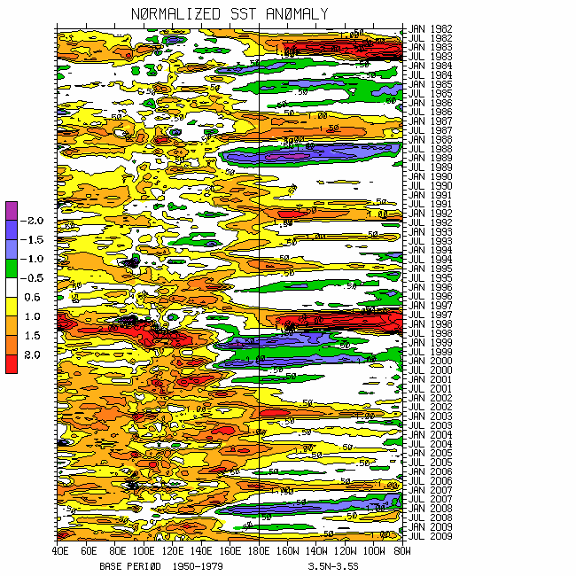
http://www.cdc.noaa.gov/map/images/sst/sst.long.time.io.gif
There is no change to the weather-climate dynamical system involving mixed complicated signals. This is one reason for the relatively weak projections in both the WH (2004) MJO and WB (2009) GWO phase spaces (keeping in mind the details of these measures). Hence the confidence of any subseasonal and longer predictions must be inherently low.
Tropical convective forcing with the MJO did erupt across the Indian Ocean during the last 5-7 days. However, as I expected given the history of this event (see past discussions), the equatorial signal is propagating east very quickly, ~15-20m/s per my own “back of the envelope” calculations. Supportive of the latter is the projection onto convectively coupled Kelvin waves per coherent modes Hovmollers. Full disk satellite imagery suggests there is some consolidation occurring ~120E north of the equator. For reasons that I will only briefly discuss in the following, I think we may be looking at another behavior of tropical forcing having some similarities to this past March-April.
The atmospheric circulation has been drifting back toward La-Nina during the past couple of weeks ("over bought" atmosphere?), related to the tropical forcing but also involving GWO processes as defined in WB (2009). Total (not relative) AAM has dipped to ~1 sigma below the R1 data climatology (through 14 May), with significant contributions coming from the subtropical atmospheres of both hemispheres dominated by anomalous zonal mean easterly wind flows. In fact, latest weekly averages of these anomalous easterlies at 250mb have been greater than 5m/s. Furthermore, there is once again interhemispheric meridional symmetry of zonal mean zonal wind anomalies favoring strong midlatitude ridges. Even though the global signal is weak (competing terms in the AAM budget), phase 3 of the GWO 250mb psi composite anomaly plots reasonably depicts the current tropospheric circulation.
The astute readers will notice that the distribution of zonal mean relative AAM anomalies is similar to early-mid March, including the equatorial positive signal (cyclonic shear in the subtropics). There are also some similarities with the other terms, including the frictional torque and the transports (see plots). A notable difference to me is that there are no anomalous upper tropospheric subtropical troughs in the region of the Dateline. In fact, I could suggest that these troughs have been displaced into the east Pacific with anticyclones around the Dateline/west Pacific Ocean. In other words, the possibility exists that the ENSO background state in the tropics has been shifted east, perhaps as the result of the past 2 stochastically (GWO) driven MJOs. Interestingly, the Australian jet has been anomalously strong the past 1-2 weeks. Are we seeing a forcing-response-feedback loop, and is this the “hard reality” of ENSO transition, should that be the case?
Regardless, my point is I think it is probable the tropical forcing will get established ~0/140E during the next couple of weeks, then perhaps also continue east as a MJO into the Western Hemisphere. The WH (2004) MJO projection may do a “loop inside the magic 1-sigma circle of death”, then come out and "hang around" in octants 7-8 for a while. Remembering that the WB (2009) measure of the GWO is a global dynamical quantity tied to ENSO, its projection may remain relatively weak until the interannual component of the weather-climate system clarifies.
The global circulation may behave as shown by phases 3-5 of the GWO 250mb psi composite anomaly plots during the next couple of weeks. Weeks 3-4 may see a loose GWO/MJO superposition of phases 6-8. At some point during early-mid June a form of at least GWO 7-8-1 transition may be probable. Until we can show maps having several variables with verifiable probabilities, this forecast information will continue to be confusing to many users.
For the USA, with variations that suggests troughs off/around the west coast and the region of the eastern states, with anomalous ridging west of the Mississippi River the rest of this month. Anomalous low pressure in the Gulf of Mexico including the possibility of a hybrid tropical cyclone (Anna?; SSTs are marginal, refer to official forecasts) combined with the above may give the Plains some respite from severe local storms at times. During the first couple weeks of June strong progressive troughs may again shift into the western and central states poleward of ~35-40N. That may (again, very low confidence) lead to the situation I discussed in my 9 May posting.
Appendix
All presentations from the 24 February 2009 GWO workshop are available via anonymous ftp. If you have not received information on how to retrieve these, let me know. There was excellent attendance at this day-long event, and feedback was strongly positive. We are working to mainstream this effort. The support is very much appreciated!
Links to CPC and PSD ENSO discussions, and a new experimental forecast technique involving a coupled LIM (3rd link below):
http://www.cpc.ncep.noaa.gov/products/analysis_monitoring/enso_advisory/index.shtml
http://www.cdc.noaa.gov/people/klaus.wolter/MEI/
http://www.cdc.noaa.gov/forecasts/clim/
The following are links to information about the stratosphere and other nice monitoring tools:
http://ds.data.jma.go.jp/tcc/tcc/products/clisys/index.html
http://code916.gsfc.nasa.gov/Data_services/met/ann_data.html (new stratosphere link!)
The following is a link to NCEP model verifications (surf around for lots more):
http://www.cpc.ncep.noaa.gov/schemm/z500ac_wk2_na.html
The following is a link discussing recent global weather and related events:
http://www.wmo.ch/pages/mediacentre/news/index_en.html
These are probabilistic statements. We hope that an opportunity will arise for us (soon) to allow our dedicated web page effort to mature, expediting objectively and accountability. This web page effort will hopefully include an objective predictive scheme for the GWO with hindcasts.
The WB (2007) paper on the GSDM has been published in the February issue of MWR. The first of a two-part paper, where WB formally introduce the GWO (WB (2009)), is (still) awaiting publication in MWR. An early on-line release can be downloaded from the following link:
http://ams.allenpress.com/archive/1520-0493/preprint/2008/pdf/10.1175_2008MWR2686.1.pdf
In addition to the subseasonal snr composite anomaly plots, we would like near real-time discussions with “weather maps” to become a routine part of the ESRL/PSD GSDM web site sometime soon. Part-2 of our GWO paper will discuss the latter. We want to emphasize notions such as global-zonal mean-regional scale linkages as well as forcing-response-feedback (with subsequent interactions) relationships. An important purpose is to provide a dynamical weather-climate linkage framework to evaluate the numerical models in a sophisticated manner as part of a complete subseasonal (and any time scale) forecast process, in addition to a climate service for all users. Relying on the numerical models alone is a cookbook, extremely unscientific, and makes Rex the Rottweiler VERY angry! I am planning on posting a discussion next weekend, 22-24 May.
Ed Berry
7 comments:
Hello Ed,
First of all, I would like to thank you for your continued dedication to your articles. Most of it is still leaving me scratching my head, but hopefully one day I will be able to piece it all together.
Are phases 3-5 of the GWO 250mb psi composite a transition out of La-Nina?
The GFS is the most aggressive model with the hybrid tropical/subtropical system. Do you believe it will become the Atlantic's first named storm?
Hello Greg,
Thank you for the comment! Phases 3-5 of the GWO, particularly ~4-5, are at the weak end of La-Nina. In general, be it tied to a MJO, extratropical variation involving the mountains, etc., phases 1 and 5 are transitional and 3 (La-Nina like) and 7 (El-Nino like) more persistent. During the last couple of years, GWO phase 3 has generally been dominate.
The SSTs in the Gulf of Mexico are marginal, ~26-27C, warming as you get deeper into the Caribbean. They have been cooler than normal given frequent cold frontal passages this spring. We will see what happens.
Ed
Just amazing stuff. I learn more everytime I read your blog. Thank you for your hard work!!!!
--Matt Powers, College of Dupage (Nexlab)
Your articles are always very informative BUT my response to this one is a STANDING OVATION!!! You depicted the tangled atmospheric brilliantly.
Here in NC I cannot help but anticipate the coming of major early June heat, late April/Early May style. Should a replay of last year's furnace (early June) occur then it will be interesting to see if other arguments emerge for a regime change in the global circulation.
To me, "full circle", would be evidence for a version of 2008-09 to be on the table for the winter season. Is there a specific signal that you are looking for that would be a definitive indicator that "El Viejo" is not in the cards for Winter 2009-10?
Thanks!
Hello Matt and "Captain Climate",
Thank you for the comments! To answer "Captain Climate's" question, one signal I will be monitoring during the next several months is if tropical convective forcing with MJOs has additional impact due to WWBs on the equator across the western and central Pacific Ocean. That could lead to additional eastward movement of anomalously warm SSTs. So far, I am not impressed with the heat content west of the Dateline.
Should tropical forcing get re-established farther west, anomalous trade surges may resume across the central and west Pacific. As I have typed before, "major ENSO events" like to come in threes. The jury is definitely still out.
Ed
Hello, Ed
What do you think the Southwest monsoon season has in store for us this year. It seems as though its off to an early start. Will MJO play a part in this?
Thanks again for all of your info on all of your articles
Hello "B",
Thank you for the comment. The early start is a response to strong tropical-extratropical interactions including the on-going MJO. The rest of the warm season is unclear relative to climatology given the uncertain ENSO situation. Please see the discussion I just posted.
Ed
Post a Comment