“The views expressed are those of the author and do not necessarily represent those of the National Weather Service.”
Please keep in mind the ESRL/PSD GSDM web link, below, while reading this discussion.
http://www.cdc.noaa.gov/map/clim/gsdm.composites.shtml
Map room issues continue and are being worked on.
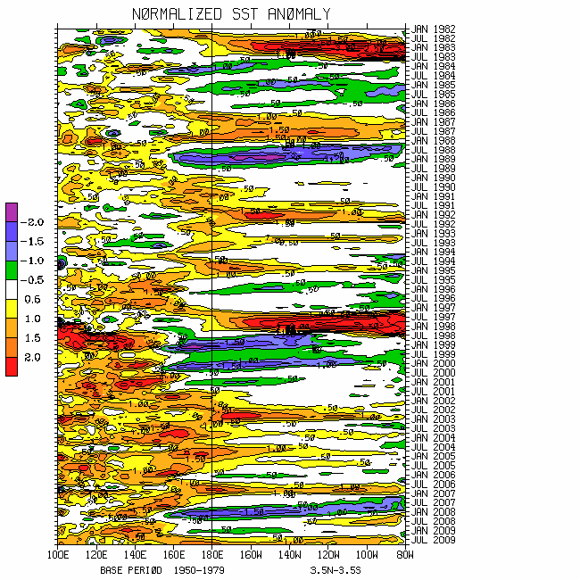
Please see links below for SSTs. Strengthening trades during the last week has renewed cooling of SSTs across all Nino regions. TAO buoy data show 5-day averaged anomalies ~minus 1-1.5C along the equatorial
http://www.wmo.int/pages/prog/wcp/wcasp/enso_update_latest.html
http://iri.columbia.edu/climate/ENSO/currentinfo/technical.html
http://www.pmel.noaa.gov/tao/jsdisplay/
http://www.cdc.noaa.gov/forecasts/sstlim/Seas.html (note the initial projection)
http://www.cpc.ncep.noaa.gov/products/precip/CWlink/MJO/index.primjo.html (link 18)
http://www.cdc.noaa.gov/map/images/sst/sst.long.time.gif
The global weather-climate situation is extremely complicated. While I do feel comfortable with any diagnosis I can offer, this medium of communication is not a good facilitator. From my viewpoint of the global ocean-land-atmosphere dynamical system, La-Nina is well entrenched. Tropical convective forcing has consolidated nicely ~0/130-140E extending from the
The wind and convective signals are loosely getting back into sync, as are the tropics and extratropics. A “messy” Eastern Hemisphere subtropical transition to anomalous upper tropospheric
However, similar to a year ago and not cleanly observed during this “encore”, there is now respectable interhemispheric meridional symmetry of zonally symmetric zonal mean zonal wind anomalies. These include ~5m/s 200mb zonal mean easterly wind flow anomalies throughout the Northern Hemisphere subtropical atmosphere, and easterly anomalies in excess of 10m/s ~75N (more said below). Reflective of a poleward shifted zonal mean polar jet; 200mb westerly wind flow anomalies of roughly 5m/s exist at 45N.
Also similar to the 2007-08 strong El-Viejo, the Northern Hemisphere midlatitude circulation is characterized by anomalous ridges suggesting a positive phase of a Branstator (2002) circumglobal teleconnection. Phase 3 of the GWO 250mb psi snr composite anomaly plot depicts this situation. Along with phase 4 for the MJO depicting tropical anomalies, a superposition of these composites is broadly representative of the global circulation. This response may continue for the next several weeks.
Updated through 3 February, global relative AAM is ~1.5-2 sigma below the R1 data climatology, an upward trend from its low of ~minus 2.5 sigma a couple of weeks ago (bear atmosphere rally?!). Including contributions from the surface torques, relative AAM tendency has increased to ~plus 15 Hadleys the last week or so. However, the WB (2009) measure of the GWO remains locked in octants 3-4 of phase space, strongly shifted toward the La-Nina attractor comparable to that observed during the 2007-08 boreal winter/spring. I do think a slow orbit is probable during the next few weeks, tilted toward La-Nina.
The record breaking (data going back to 1978) major sudden stratospheric warming (SSW) continues. See links in the Appendix for details. The zonal wave number 2 pattern of Northern Hemisphere higher latitude anomalous continental cyclones (~100E ad 100W) and ocean ridges bridging the pole has propagated down to at least 200mb. Surface weather across large portions of the Northern Hemisphere is already being impacted. A synoptic response has been for the European blocking (which played a role in the recent
In any case, arguably GWO processes starting December 2008 contributed to the SSW, and now the SSW is feeding back to the GWO. For instance, the polar latitude strongly anomalous upper tropospheric zonal mean easterly wind flow is helping to keep global AAM low, in a sense constructively interfering with La-Nina. Furthermore, AAM eddy transports from both the subtropics and high latitudes may be contributing to the anomalous westerly wind flow ~45N. Regardless of the details, working with what may be a maturing quasi-stationary La-Nina base state, tropospheric impacts from the SSW will continue for the next several weeks. Stratospheric time scales are very slow.
Regionally, the central
Somewhat typical of a La-Nina, much of the Arctic air (surface temperatures well under minus 50F across Siberia) is displaced toward
Appendix
The formal announcement including an additional expanded outline for the 24 February 2009 one-day (~830am-530pm MST) workshop on the WB (2009) GWO has been released through various mailing lists, and is available on the ESRL/PSD GSDM web link. Let me know if you have not seen it. Please remember the intended audience of this workshop is forecasters who make daily subseasonal predictions. It will not be a “head banger’s academic ball”.
Links to CPC and PSD ENSO discussions:
http://www.cpc.ncep.noaa.gov/products/analysis_monitoring/enso_advisory/index.shtml
http://www.cdc.noaa.gov/people/klaus.wolter/MEI/
The following are links to information about the stratosphere and other nice monitoring tools:
http://ds.data.jma.go.jp/tcc/tcc/products/clisys/index.html
http://code916.gsfc.nasa.gov/Data_services/met/ann_data.html (new stratosphere link!)
The following is a link to NCEP model verifications (surf around for lots more)
http://www.cpc.ncep.noaa.gov/schemm/z500ac_wk2_na.html .
The following is a link discussing recent global weather and related events:
http://www.wmo.ch/pages/mediacentre/news/index_en.html
These are probabilistic statements. We hope that an opportunity will arise for us (soon) to allow our dedicated web page effort to mature, expediting objectively and accountability. This web page effort will hopefully include an objective predictive scheme for the GWO with hindcasts.
The WB (2007) paper on the GSDM has been published in the February issue of MWR. The first of a two-part paper, where WB formally introduce the GWO (WB (2009)), is awaiting publication in MWR. A pdf of an in press version can be downloaded from the following link:
http://www.cdc.noaa.gov/map/clim/wb08_revised_final.pdf
In addition to the subseasonal snr composite anomaly plots, we would like near real-time discussions with “weather maps” to become a routine part of the ESRL/PSD GSDM web site sometime soon. Part-2 of our GWO paper will discuss the latter. We want to emphasize notions such as global-zonal mean-regional scale linkages as well as forcing-response-feedback (with subsequent interactions) relationships. An important purpose is to provide a dynamical weather-climate linkage framework to evaluate the numerical models in a sophisticated manner as part of a subseasonal (and any time scale) forecast process, in addition to a climate service for all users. Relying on the numerical models alone is a cookbook, and unscientific!
Discussions will be very difficult to publish the next few weeks given shift work and preparations for the GWO workshop. I will attempt to post “something” ~13-15 February.
Ed Berry