“The views expressed are those of the author and do not necessarily represent those of the National Weather Service.”
Please keep in mind the ESRL/PSD GSDM web link, below, while reading this discussion.
http://www.cdc.noaa.gov/map/clim/gsdm.composites.shtml
The composites are still centered on 1 July, and work is on-going to update them regularly. Stay tuned. Again, this effort is a work in progress with extremely limited resources.
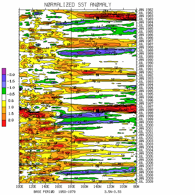
The following are links to global SST information. Weak warm SST anomalies (~0.5C per TAO buoy data) continue from the west coast of South America into the equatorial
http://www.wmo.int/pages/prog/wcp/wcasp/enso_update_latest.html
http://iri.columbia.edu/climate/ENSO/currentinfo/technical.html
http://www.pmel.noaa.gov/tao/jsdisplay/
http://www.cdc.noaa.gov/forecast1/IndoPacific.frcst.html (note the initial projection)
http://www.cpc.ncep.noaa.gov/products/precip/CWlink/MJO/index.primjo.html (link 18)
http://www.cdc.noaa.gov/map/images/sst/sst.long.time.gif
As was offered on my 23 July posting, Eastern Hemisphere tropical convective forcing has been slowly propagating east-northeast toward the northwest
During the last half of July dynamical processes tied to the tropical convection and the extratropics worked to add global westerly wind flow. In fact, relative AAM peaked just above the R1 data climatology ~30 July. Anomalous zonal mean westerly wind flow was generated in the northern equatorial atmosphere around mid-July, only to propagate poleward and downward since. The latter has been in the presence of other midlatitude zonal bands of anomalous westerly wind flow. Particularly in the austral winter Southern Hemisphere storm track regions, frictional dissipation of this westerly wind flow has been occurring over the last couple of weeks. In fact, the zonal mean frictional torque anomaly around 25S has been minus 2 Hadleys and lower.
Continuing, my point is that I think once again westerly wind flow is decreasing globally. For example, Rossby wave energy dispersions (RWDs) tied to the Eastern Hemisphere tropical convective forcing arcing across the South Pacific Ocean is contributing to a strong negative
One bottom line for predictive purposes is that I do expect a signal having a MJO component to propagate through the
However, I think it is less likely there will be the strong enhancement around the
Another bottom line is that the quasi-stationary component to our global circulation base state favoring a low AAM regime has not completely gone away. The recurring convective flare-ups over the western equatorial
On my 23 July discussion I suggested with low confidence a “pattern shift of sorts” across the
However, my feelings for success of this subseasonal prediction are limited and mixed. I was favoring a stationary pattern given by phases 3-4 of the GWO 250mb psi and temperature anomaly composites. Instead, a relatively large orbit in GWO phase space occurred.
For weeks 1-3, interestingly enough, with variations understood, phases 3-4 and 4-5 of the GWO anomaly composites (250mb psi and temperature) along with MJO temperature anomaly phases 4 and 5 appear to be the most probable outcome for the country. Again, these are composite signals and need to be updated. Also, given recent relatively weak weather-climate signals and a tendency for “fading in and out (not discussed)”, my confidence remains low.
As the Plains cool down next week, intense MCS activity may shift southward impacting locations from eastern Colorado-Wyoming into at least
Intense to severe tropical thunderstorm activity should shift east and north through portions of
Please see the latest official tropical cyclone forecasts for all basins. I trust the expertise of the appropriate meteorological centers to alert the public of additional weather hazards worldwide.
Appendix
Links to CPC and PSD ENSO discussions:
http://www.cpc.ncep.noaa.gov/products/analysis_monitoring/enso_advisory/index.shtml
http://www.cdc.noaa.gov/people/klaus.wolter/MEI/
The following is a link to information about the stratosphere and other nice monitoring tools:
http://ds.data.jma.go.jp/tcc/tcc/products/clisys/index.html
The following is a link to NCEP model verifications (surf around for lots more).
http://www.cpc.ncep.noaa.gov/schemm/z500ac_wk2_na.html
The following is a link discussing recent global weather and related events.
http://www.wmo.ch/pages/mediacentre/news/index_en.html
These are probabilistic statements. We hope that an opportunity will arise for us (soon) to allow our dedicated web page effort to mature, expediting objectively and accountability. This web page effort will hopefully include an objective predictive scheme for the GWO with hindcasts.
The WB (2007) paper on the GSDM has been published in the February issue of MWR. In addition, the first of a two-part paper has been submitted to MWR where WB formally introduce the GWO. A pdf version can be downloaded from the following link
http://www.cdc.noaa.gov/map/clim/wb08_final.pdf
Overlapping seasonally varying subseasonal composites for variables such as surface temperature, precipitation, geopotential height and streamfunction anomalies are planned on being posted on the web site mentioned above and presented in part-2 of our paper. We want to emphasize notions such as global-zonal mean-regional scale linkages as well as forcing-response-feedback (with subsequent interactions) relationships. An important purpose is to provide a dynamical weather-climate linkage framework to evaluate the numerical models in a sophisticated manner as part of a subseasonal (and any time scale) forecast process, in addition to a climate service for all users. Relying on the numerical models alone is a cookbook!
Given shift work and travel, updates are extremely difficult. I hope to do another discussion late next week.
Ed Berry