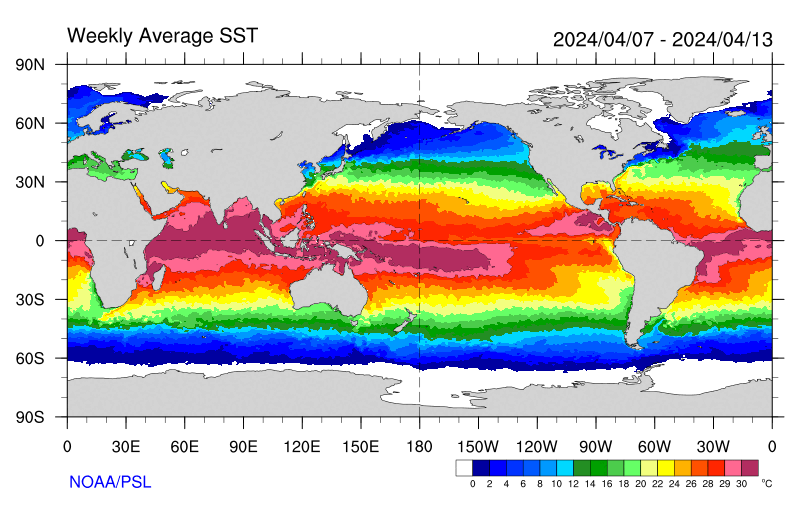
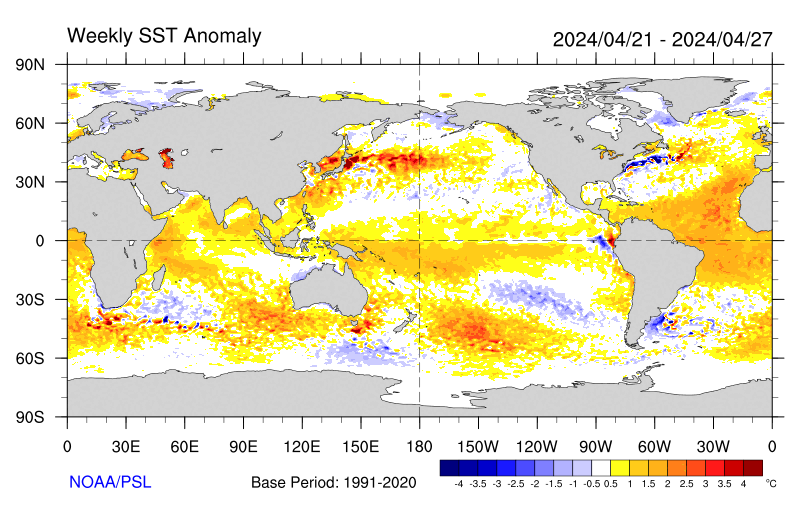
Tropical Pacific and Indian Ocean SSTs have changed relatively little since the last Blog posting on March 4th. As shown by the following links, La-Nina conditions remain (SSTs for the Atlantic and other ocean basins can also be obtained from navigation):
http://www.cdc.noaa.gov/map/images/sst/sst.gif
http://www.cdc.noaa.gov/map/images/sst/sst.anom.gif
http://www.pmel.noaa.gov/tao/jsdisplay/
Tropical convection continues over SSTs of 29C and greater, with the most intense centered on Indonesia near the equator from ~110-150E. During the past couple of days, this convection has drifted northward while extending east-southeast along the SPCZ toward the Polynesian Islands. Strong convection is also present from South Africa toward Madagascar as well as much of northern South America. Considering variations such as convectively coupled Kelvin and Rossby modes and even the diurnal cycle, the above described pattern of tropical forcing has been nearly stationary for at least the past week-10 days. The MJO signal has been very weak. As mentioned in the last posting, in terms of tropical convection, the forcing is believed to stationary and there may even be some coupling between the atmosphere and the SSTs. Stationary forcing would be probable during a La-Nina (as well as El-Nino, but with an essentially reversed distribution of tropical convection anomalies).
The circulation response is loosely consistent with what would be expected (in a composite sense) with the tropical forcing across the eastern hemisphere (EH). Interacting with synoptic variability, twin anomalous upper tropospheric subtropical anticyclones have appeared from Africa into the geographical areas of the IO and Indonesia, while twin subtropical cyclones have been present in the region of the date line. In the lower levels, while the trades have been strong east of Indonesia, actual westerlies were occuring north of Australia, all as part of a possible SST forcing atmosphere via convection positive feedback mechanism.
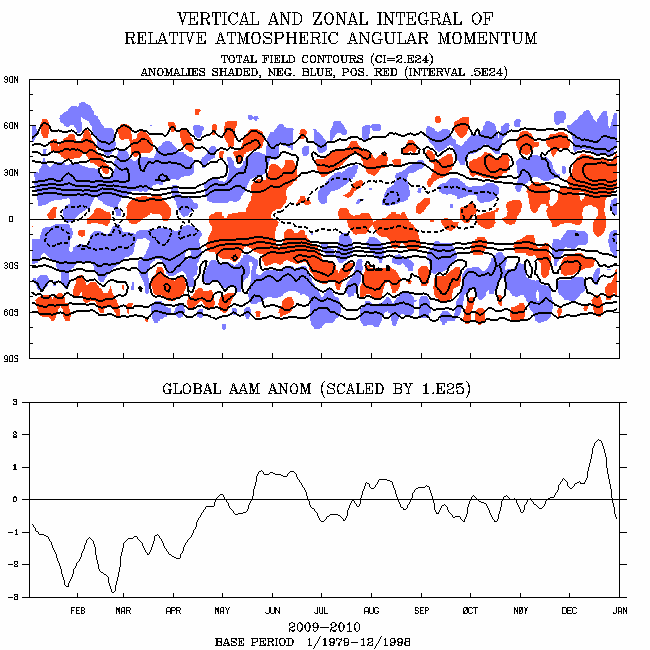
Linked mostly to the twin cyclones, zonal mean upper tropospheric westerly flow has been ~5-10m/s above average across the tropical and subtropical atmospheres for at least the past couple of weeks. Much of that has been in the western hemisphere (WH), including the anomalously moist STJ that has contributed to the heavy rainfall across Hawaii and the USA west coast for the past week. Recently zonal mean anomalous easterly flow has developed across subtropics particularly south of the equator, with the westerlies shifting poleward. This observation is consistent with the notion of La-Nina coupling, and AAM should be currently decreasing. In fact, the operational plot at
http://www.cdc.noaa.gov/map/images/aam/glaam.gif is supportive (uses 1979-1998 climatology verses the 1968-1997 period of the NCEP/NCAR reanalysis plots, latter which lag at least 3 days from current). Finally, also connsistent with EH tropical forcing and La-Nina, split jet stream flows have been observed across the central and eastern ccean basins of the northern extratropics. In general SDM Stages 1-2 best characterize our weather-climate situation, and it is probable that will continue for at least the next 2 weeks.
Putting into perspective for the PNA region, there has been a general east Asian trough-central Pacific ridge (with the subtropical low west of Hawaii as part of the split flow)-eastern Pacific/western USA trough pattern for at least the past week-10 days. This structure has projected onto the negative phase of the PNA teleconnection index. A Rossby wave energy dispersion (RWD) on ~March 1st, linked to the subtropical lows as part of the base state discussed above, lead to the first in a series of deep troughs for the western USA last weekend. Several more troughs are following as the parent baroclinic wave packet moves through the WH. Most models show the last in this particular series of troughs to dig deeply into the western states by the end of this upcoming weekend and then move northeast into the Plains. That is reasonable, understanding uncertainty with the details.
What I think the models have been struggling with the last few days is what happens after this weekend in terms of the circulation. From monitoring I can see that the above mentioned wave packet is rapidly coming back around into the EH subtropics. In fact, the recent blow-up of thunderstorm activity across India is being forced by the trough at the leading edge of this packet. Initially, as this subtropical wave packet interacts with the Indonesian convection (and possibly intensifies it), another RWD may occur leading to another trough digging into the east Pacific just off the USA west coast by ~ middle of next week. Similar to what has already occurred, the southern portion may break anticyclonically and re-enforce the subtropical cyclone west of Hawaii. Also from monitoring there has been~10-20 amplification periodicity forced by the east Asian topography. Trying to understand the interaction of this faster mode within the La-Nina stationary base state in anything but trivial; however, I do think ALL that may translate to more at least seasonably deep troughs for the west coast/western CONUS ~next weekend into the week of March 20th.
In my last posting I went into some length about the "weather consequences" of the above discussed reverse PNA pattern for the USA, and will not repeat here. While the west coast, particularly the Pacific Northwest gets a break from the stormy weather by early next week, at least a typical March event of baroclinic cyclogenesis is probable across the middle of the country Monday-Wednesday. In its wake, colder air will spread east and southeast from the western states across much of the country.
By next weekend into the following week, another period of active weather may return from the west coast into the Plains and Ohio Valley. Heavy precipitation would again be a concern for those areas, including severe storms from the central and southern Plains into the Ohio Valley, and winter precipitation with elevated (possibly intense) thunderstorms from the Rockies into the Upper Mississippi Valley.
Now comes the story of Southwest Kansas. Even with all the above discussed active weather, can we at least get one decent precipitation event? In my last posting I tried to be optimistic. I am afraid I will have to back off on that. Simply put, it is still too early in the year for deep layered tropical moisture to get transported this far west to interact with the intense troughs/jet streaks moving out of the Rockies. As soon as the moisture makes a run, here comes a trough, southwestly momentum is quickly transferred downward given our elevated terrain, and we mix out. In some sense this is just another rain shawdowing effect of the Rockies. As we get later into spring, at least a couple of factors become more favorable. First, deep Gulf of Mexico tropical moisture may already be in place across Texas and Oklahoma; and secondly, the magnitude of the westerly flow weakens with the seasonal cycle. So, perhaps by ~mid May and afterwards, with "this type of pattern", our precipitation chances should be much better. For now, we will leave it at that.
Other than the "nickel and dime stuff" of high-based scattered showers and storms that may occur as each trough goes by, I see little opportunity of the decent welcome precipitation that everyone wants for at least next two weeks. In fact, what may become a concern is both increased fire danger and perhaps a dust storm. Nevertheless, we need to monitor, and hopefully I will eat crow. Temperatures should trend toward below normal by early next week, only to warm to near or above by late next week.
Ed Berry
Wednesday, March 08, 2006

The Atmosphere is Happy
Tropical Pacific and Indian Ocean SSTs have changed relatively little since the last Blog posting on March 4th. As shown by the following links, La-Nina conditions remain (SSTs for the Atlantic and other ocean basins can also be obtained from navigation):
http://www.cdc.noaa.gov/map/images/sst/sst.gif
http://www.cdc.noaa.gov/map/images/sst/sst.anom.gif
http://www.pmel.noaa.gov/tao/jsdisplay/
Tropical convection continues over SSTs of 29C and greater, with the most intense centered on Indonesia near the equator from ~110-150E. During the past couple of days, this convection has drifted northward while extending east-southeast along the SPCZ toward the Polynesian Islands. Strong convection is also present from South Africa toward Madagascar as well as much of northern South America. Considering variations such as convectively coupled Kelvin and Rossby modes and even the diurnal cycle, the above described pattern of tropical forcing has been nearly stationary for at least the past week-10 days. The MJO signal has been very weak. As mentioned in the last posting, in terms of tropical convection, the forcing is believed to stationary and there may even be some coupling between the atmosphere and the SSTs. Stationary forcing would be probable during a La-Nina (as well as El-Nino, but with an essentially reversed distribution of tropical convection anomalies).
The circulation response is loosely consistent with what would be expected (in a composite sense) with the tropical forcing across the eastern hemisphere (EH). Interacting with synoptic variability, twin anomalous upper tropospheric subtropical anticyclones have appeared from Africa into the geographical areas of the IO and Indonesia, while twin subtropical cyclones have been present in the region of the date line. In the lower levels, while the trades have been strong east of Indonesia, actual westerlies were occuring north of Australia, all as part of a possible SST forcing atmosphere via convection positive feedback mechanism.
Linked mostly to the twin cyclones, zonal mean upper tropospheric westerly flow has been ~5-10m/s above average across the tropical and subtropical atmospheres for at least the past couple of weeks. Much of that has been in the western hemisphere (WH), including the anomalously moist STJ that has contributed to the heavy rainfall across Hawaii and the USA west coast for the past week. Recently zonal mean anomalous easterly flow has developed across subtropics particularly south of the equator, with the westerlies shifting poleward. This observation is consistent with the notion of La-Nina coupling, and AAM should be currently decreasing. In fact, the operational plot at
http://www.cdc.noaa.gov/map/images/aam/glaam.gif is supportive (uses 1979-1998 climatology verses the 1968-1997 period of the NCEP/NCAR reanalysis plots, latter which lag at least 3 days from current). Finally, also connsistent with EH tropical forcing and La-Nina, split jet stream flows have been observed across the central and eastern ccean basins of the northern extratropics. In general SDM Stages 1-2 best characterize our weather-climate situation, and it is probable that will continue for at least the next 2 weeks.
Putting into perspective for the PNA region, there has been a general east Asian trough-central Pacific ridge (with the subtropical low west of Hawaii as part of the split flow)-eastern Pacific/western USA trough pattern for at least the past week-10 days. This structure has projected onto the negative phase of the PNA teleconnection index. A Rossby wave energy dispersion (RWD) on ~March 1st, linked to the subtropical lows as part of the base state discussed above, lead to the first in a series of deep troughs for the western USA last weekend. Several more troughs are following as the parent baroclinic wave packet moves through the WH. Most models show the last in this particular series of troughs to dig deeply into the western states by the end of this upcoming weekend and then move northeast into the Plains. That is reasonable, understanding uncertainty with the details.
What I think the models have been struggling with the last few days is what happens after this weekend in terms of the circulation. From monitoring I can see that the above mentioned wave packet is rapidly coming back around into the EH subtropics. In fact, the recent blow-up of thunderstorm activity across India is being forced by the trough at the leading edge of this packet. Initially, as this subtropical wave packet interacts with the Indonesian convection (and possibly intensifies it), another RWD may occur leading to another trough digging into the east Pacific just off the USA west coast by ~ middle of next week. Similar to what has already occurred, the southern portion may break anticyclonically and re-enforce the subtropical cyclone west of Hawaii. Also from monitoring there has been~10-20 amplification periodicity forced by the east Asian topography. Trying to understand the interaction of this faster mode within the La-Nina stationary base state in anything but trivial; however, I do think ALL that may translate to more at least seasonably deep troughs for the west coast/western CONUS ~next weekend into the week of March 20th.
In my last posting I went into some length about the "weather consequences" of the above discussed reverse PNA pattern for the USA, and will not repeat here. While the west coast, particularly the Pacific Northwest gets a break from the stormy weather by early next week, at least a typical March event of baroclinic cyclogenesis is probable across the middle of the country Monday-Wednesday. In its wake, colder air will spread east and southeast from the western states across much of the country.
By next weekend into the following week, another period of active weather may return from the west coast into the Plains and Ohio Valley. Heavy precipitation would again be a concern for those areas, including severe storms from the central and southern Plains into the Ohio Valley, and winter precipitation with elevated (possibly intense) thunderstorms from the Rockies into the Upper Mississippi Valley.
Now comes the story of Southwest Kansas. Even with all the above discussed active weather, can we at least get one decent precipitation event? In my last posting I tried to be optimistic. I am afraid I will have to back off on that. Simply put, it is still too early in the year for deep layered tropical moisture to get transported this far west to interact with the intense troughs/jet streaks moving out of the Rockies. As soon as the moisture makes a run, here comes a trough, southwestly momentum is quickly transferred downward given our elevated terrain, and we mix out. In some sense this is just another rain shawdowing effect of the Rockies. As we get later into spring, at least a couple of factors become more favorable. First, deep Gulf of Mexico tropical moisture may already be in place across Texas and Oklahoma; and secondly, the magnitude of the westerly flow weakens with the seasonal cycle. So, perhaps by ~mid May and afterwards, with "this type of pattern", our precipitation chances should be much better. For now, we will leave it at that.
Other than the "nickel and dime stuff" of high-based scattered showers and storms that may occur as each trough goes by, I see little opportunity of the decent welcome precipitation that everyone wants for at least next two weeks. In fact, what may become a concern is both increased fire danger and perhaps a dust storm. Nevertheless, we need to monitor, and hopefully I will eat crow. Temperatures should trend toward below normal by early next week, only to warm to near or above by late next week.
Ed Berry
http://www.cdc.noaa.gov/map/images/sst/sst.gif
http://www.cdc.noaa.gov/map/images/sst/sst.anom.gif
http://www.pmel.noaa.gov/tao/jsdisplay/
Tropical convection continues over SSTs of 29C and greater, with the most intense centered on Indonesia near the equator from ~110-150E. During the past couple of days, this convection has drifted northward while extending east-southeast along the SPCZ toward the Polynesian Islands. Strong convection is also present from South Africa toward Madagascar as well as much of northern South America. Considering variations such as convectively coupled Kelvin and Rossby modes and even the diurnal cycle, the above described pattern of tropical forcing has been nearly stationary for at least the past week-10 days. The MJO signal has been very weak. As mentioned in the last posting, in terms of tropical convection, the forcing is believed to stationary and there may even be some coupling between the atmosphere and the SSTs. Stationary forcing would be probable during a La-Nina (as well as El-Nino, but with an essentially reversed distribution of tropical convection anomalies).
The circulation response is loosely consistent with what would be expected (in a composite sense) with the tropical forcing across the eastern hemisphere (EH). Interacting with synoptic variability, twin anomalous upper tropospheric subtropical anticyclones have appeared from Africa into the geographical areas of the IO and Indonesia, while twin subtropical cyclones have been present in the region of the date line. In the lower levels, while the trades have been strong east of Indonesia, actual westerlies were occuring north of Australia, all as part of a possible SST forcing atmosphere via convection positive feedback mechanism.
Linked mostly to the twin cyclones, zonal mean upper tropospheric westerly flow has been ~5-10m/s above average across the tropical and subtropical atmospheres for at least the past couple of weeks. Much of that has been in the western hemisphere (WH), including the anomalously moist STJ that has contributed to the heavy rainfall across Hawaii and the USA west coast for the past week. Recently zonal mean anomalous easterly flow has developed across subtropics particularly south of the equator, with the westerlies shifting poleward. This observation is consistent with the notion of La-Nina coupling, and AAM should be currently decreasing. In fact, the operational plot at
http://www.cdc.noaa.gov/map/images/aam/glaam.gif is supportive (uses 1979-1998 climatology verses the 1968-1997 period of the NCEP/NCAR reanalysis plots, latter which lag at least 3 days from current). Finally, also connsistent with EH tropical forcing and La-Nina, split jet stream flows have been observed across the central and eastern ccean basins of the northern extratropics. In general SDM Stages 1-2 best characterize our weather-climate situation, and it is probable that will continue for at least the next 2 weeks.
Putting into perspective for the PNA region, there has been a general east Asian trough-central Pacific ridge (with the subtropical low west of Hawaii as part of the split flow)-eastern Pacific/western USA trough pattern for at least the past week-10 days. This structure has projected onto the negative phase of the PNA teleconnection index. A Rossby wave energy dispersion (RWD) on ~March 1st, linked to the subtropical lows as part of the base state discussed above, lead to the first in a series of deep troughs for the western USA last weekend. Several more troughs are following as the parent baroclinic wave packet moves through the WH. Most models show the last in this particular series of troughs to dig deeply into the western states by the end of this upcoming weekend and then move northeast into the Plains. That is reasonable, understanding uncertainty with the details.
What I think the models have been struggling with the last few days is what happens after this weekend in terms of the circulation. From monitoring I can see that the above mentioned wave packet is rapidly coming back around into the EH subtropics. In fact, the recent blow-up of thunderstorm activity across India is being forced by the trough at the leading edge of this packet. Initially, as this subtropical wave packet interacts with the Indonesian convection (and possibly intensifies it), another RWD may occur leading to another trough digging into the east Pacific just off the USA west coast by ~ middle of next week. Similar to what has already occurred, the southern portion may break anticyclonically and re-enforce the subtropical cyclone west of Hawaii. Also from monitoring there has been~10-20 amplification periodicity forced by the east Asian topography. Trying to understand the interaction of this faster mode within the La-Nina stationary base state in anything but trivial; however, I do think ALL that may translate to more at least seasonably deep troughs for the west coast/western CONUS ~next weekend into the week of March 20th.
In my last posting I went into some length about the "weather consequences" of the above discussed reverse PNA pattern for the USA, and will not repeat here. While the west coast, particularly the Pacific Northwest gets a break from the stormy weather by early next week, at least a typical March event of baroclinic cyclogenesis is probable across the middle of the country Monday-Wednesday. In its wake, colder air will spread east and southeast from the western states across much of the country.
By next weekend into the following week, another period of active weather may return from the west coast into the Plains and Ohio Valley. Heavy precipitation would again be a concern for those areas, including severe storms from the central and southern Plains into the Ohio Valley, and winter precipitation with elevated (possibly intense) thunderstorms from the Rockies into the Upper Mississippi Valley.
Now comes the story of Southwest Kansas. Even with all the above discussed active weather, can we at least get one decent precipitation event? In my last posting I tried to be optimistic. I am afraid I will have to back off on that. Simply put, it is still too early in the year for deep layered tropical moisture to get transported this far west to interact with the intense troughs/jet streaks moving out of the Rockies. As soon as the moisture makes a run, here comes a trough, southwestly momentum is quickly transferred downward given our elevated terrain, and we mix out. In some sense this is just another rain shawdowing effect of the Rockies. As we get later into spring, at least a couple of factors become more favorable. First, deep Gulf of Mexico tropical moisture may already be in place across Texas and Oklahoma; and secondly, the magnitude of the westerly flow weakens with the seasonal cycle. So, perhaps by ~mid May and afterwards, with "this type of pattern", our precipitation chances should be much better. For now, we will leave it at that.
Other than the "nickel and dime stuff" of high-based scattered showers and storms that may occur as each trough goes by, I see little opportunity of the decent welcome precipitation that everyone wants for at least next two weeks. In fact, what may become a concern is both increased fire danger and perhaps a dust storm. Nevertheless, we need to monitor, and hopefully I will eat crow. Temperatures should trend toward below normal by early next week, only to warm to near or above by late next week.
Ed Berry
The Atmosphere is Happy
Tropical Pacific and Indian Ocean SSTs have changed relatively little since the last Blog posting on March 4th. As shown by the following links, La-Nina conditions remain (SSTs for the Atlantic and other ocean basins can also be obtained from navigation):
http://www.cdc.noaa.gov/map/images/sst/sst.gif
http://www.cdc.noaa.gov/map/images/sst/sst.anom.gif
http://www.pmel.noaa.gov/tao/jsdisplay/
Tropical convection continues over SSTs of 29C and greater, with the most intense centered on Indonesia near the equator from ~110-150E. During the past couple of days, this convection has drifted northward while extending east-southeast along the SPCZ toward the Polynesian Islands. Strong convection is also present from South Africa toward Madagascar as well as much of northern South America. Considering variations such as convectively coupled Kelvin and Rossby modes and even the diurnal cycle, the above described pattern of tropical forcing has been nearly stationary for at least the past week-10 days. The MJO signal has been very weak. As mentioned in the last posting, in terms of tropical convection, the forcing is believed to stationary and there may even be some coupling between the atmosphere and the SSTs. Stationary forcing would be probable during a La-Nina (as well as El-Nino, but with an essentially reversed distribution of tropical convection anomalies).
The circulation response is loosely consistent with what would be expected (in a composite sense) with the tropical forcing across the eastern hemisphere (EH). Interacting with synoptic variability, twin anomalous upper tropospheric subtropical anticyclones have appeared from Africa into the geographical areas of the IO and Indonesia, while twin subtropical cyclones have been present in the region of the date line. In the lower levels, while the trades have been strong east of Indonesia, actual westerlies were occuring north of Australia, all as part of a possible SST forcing atmosphere via convection positive feedback mechanism.
Linked mostly to the twin cyclones, zonal mean upper tropospheric westerly flow has been ~5-10m/s above average across the tropical and subtropical atmospheres for at least the past couple of weeks. Much of that has been in the western hemisphere (WH), including the anomalously moist STJ that has contributed to the heavy rainfall across Hawaii and the USA west coast for the past week. Recently zonal mean anomalous easterly flow has developed across subtropics particularly south of the equator, with the westerlies shifting poleward. This observation is consistent with the notion of La-Nina coupling, and AAM should be currently decreasing. In fact, the operational plot at
http://www.cdc.noaa.gov/map/images/aam/glaam.gif is supportive (uses 1979-1998 climatology verses the 1968-1997 period of the NCEP/NCAR reanalysis plots, latter which lag at least 3 days from current). Finally, also connsistent with EH tropical forcing and La-Nina, split jet stream flows have been observed across the central and eastern ccean basins of the northern extratropics. In general SDM Stages 1-2 best characterize our weather-climate situation, and it is probable that will continue for at least the next 2 weeks.
Putting into perspective for the PNA region, there has been a general east Asian trough-central Pacific ridge (with the subtropical low west of Hawaii as part of the split flow)-eastern Pacific/western USA trough pattern for at least the past week-10 days. This structure has projected onto the negative phase of the PNA teleconnection index. A Rossby wave energy dispersion (RWD) on ~March 1st, linked to the subtropical lows as part of the base state discussed above, lead to the first in a series of deep troughs for the western USA last weekend. Several more troughs are following as the parent baroclinic wave packet moves through the WH. Most models show the last in this particular series of troughs to dig deeply into the western states by the end of this upcoming weekend and then move northeast into the Plains. That is reasonable, understanding uncertainty with the details.
What I think the models have been struggling with the last few days is what happens after this weekend in terms of the circulation. From monitoring I can see that the above mentioned wave packet is rapidly coming back around into the EH subtropics. In fact, the recent blow-up of thunderstorm activity across India is being forced by the trough at the leading edge of this packet. Initially, as this subtropical wave packet interacts with the Indonesian convection (and possibly intensifies it), another RWD may occur leading to another trough digging into the east Pacific just off the USA west coast by ~ middle of next week. Similar to what has already occurred, the southern portion may break anticyclonically and re-enforce the subtropical cyclone west of Hawaii. Also from monitoring there has been~10-20 amplification periodicity forced by the east Asian topography. Trying to understand the interaction of this faster mode within the La-Nina stationary base state in anything but trivial; however, I do think ALL that may translate to more at least seasonably deep troughs for the west coast/western CONUS ~next weekend into the week of March 20th.
In my last posting I went into some length about the "weather consequences" of the above discussed reverse PNA pattern for the USA, and will not repeat here. While the west coast, particularly the Pacific Northwest gets a break from the stormy weather by early next week, at least a typical March event of baroclinic cyclogenesis is probable across the middle of the country Monday-Wednesday. In its wake, colder air will spread east and southeast from the western states across much of the country.
By next weekend into the following week, another period of active weather may return from the west coast into the Plains and Ohio Valley. Heavy precipitation would again be a concern for those areas, including severe storms from the central and southern Plains into the Ohio Valley, and winter precipitation with elevated (possibly intense) thunderstorms from the Rockies into the Upper Mississippi Valley.
Now comes the story of Southwest Kansas. Even with all the above discussed active weather, can we at least get one decent precipitation event? In my last posting I tried to be optimistic. I am afraid I will have to back off on that. Simply put, it is still too early in the year for deep layered tropical moisture to get transported this far west to interact with the intense troughs/jet streaks moving out of the Rockies. As soon as the moisture makes a run, here comes a trough, southwestly momentum is quickly transferred downward given our elevated terrain, and we mix out. In some sense this is just another rain shawdowing effect of the Rockies. As we get later into spring, at least a couple of factors become more favorable. First, deep Gulf of Mexico tropical moisture may already be in place across Texas and Oklahoma; and secondly, the magnitude of the westerly flow weakens with the seasonal cycle. So, perhaps by ~mid May and afterwards, with "this type of pattern", our precipitation chances should be much better. For now, we will leave it at that.
Other than the "nickel and dime stuff" of high-based scattered showers and storms that may occur as each trough goes by, I see little opportunity of the decent welcome precipitation that everyone wants for at least next two weeks. In fact, what may become a concern is both increased fire danger and perhaps a dust storm. Nevertheless, we need to monitor, and hopefully I will eat crow. Temperatures should trend toward below normal by early next week, only to warm to near or above by late next week.
Ed Berry
http://www.cdc.noaa.gov/map/images/sst/sst.gif
http://www.cdc.noaa.gov/map/images/sst/sst.anom.gif
http://www.pmel.noaa.gov/tao/jsdisplay/
Tropical convection continues over SSTs of 29C and greater, with the most intense centered on Indonesia near the equator from ~110-150E. During the past couple of days, this convection has drifted northward while extending east-southeast along the SPCZ toward the Polynesian Islands. Strong convection is also present from South Africa toward Madagascar as well as much of northern South America. Considering variations such as convectively coupled Kelvin and Rossby modes and even the diurnal cycle, the above described pattern of tropical forcing has been nearly stationary for at least the past week-10 days. The MJO signal has been very weak. As mentioned in the last posting, in terms of tropical convection, the forcing is believed to stationary and there may even be some coupling between the atmosphere and the SSTs. Stationary forcing would be probable during a La-Nina (as well as El-Nino, but with an essentially reversed distribution of tropical convection anomalies).
The circulation response is loosely consistent with what would be expected (in a composite sense) with the tropical forcing across the eastern hemisphere (EH). Interacting with synoptic variability, twin anomalous upper tropospheric subtropical anticyclones have appeared from Africa into the geographical areas of the IO and Indonesia, while twin subtropical cyclones have been present in the region of the date line. In the lower levels, while the trades have been strong east of Indonesia, actual westerlies were occuring north of Australia, all as part of a possible SST forcing atmosphere via convection positive feedback mechanism.
Linked mostly to the twin cyclones, zonal mean upper tropospheric westerly flow has been ~5-10m/s above average across the tropical and subtropical atmospheres for at least the past couple of weeks. Much of that has been in the western hemisphere (WH), including the anomalously moist STJ that has contributed to the heavy rainfall across Hawaii and the USA west coast for the past week. Recently zonal mean anomalous easterly flow has developed across subtropics particularly south of the equator, with the westerlies shifting poleward. This observation is consistent with the notion of La-Nina coupling, and AAM should be currently decreasing. In fact, the operational plot at
http://www.cdc.noaa.gov/map/images/aam/glaam.gif is supportive (uses 1979-1998 climatology verses the 1968-1997 period of the NCEP/NCAR reanalysis plots, latter which lag at least 3 days from current). Finally, also connsistent with EH tropical forcing and La-Nina, split jet stream flows have been observed across the central and eastern ccean basins of the northern extratropics. In general SDM Stages 1-2 best characterize our weather-climate situation, and it is probable that will continue for at least the next 2 weeks.
Putting into perspective for the PNA region, there has been a general east Asian trough-central Pacific ridge (with the subtropical low west of Hawaii as part of the split flow)-eastern Pacific/western USA trough pattern for at least the past week-10 days. This structure has projected onto the negative phase of the PNA teleconnection index. A Rossby wave energy dispersion (RWD) on ~March 1st, linked to the subtropical lows as part of the base state discussed above, lead to the first in a series of deep troughs for the western USA last weekend. Several more troughs are following as the parent baroclinic wave packet moves through the WH. Most models show the last in this particular series of troughs to dig deeply into the western states by the end of this upcoming weekend and then move northeast into the Plains. That is reasonable, understanding uncertainty with the details.
What I think the models have been struggling with the last few days is what happens after this weekend in terms of the circulation. From monitoring I can see that the above mentioned wave packet is rapidly coming back around into the EH subtropics. In fact, the recent blow-up of thunderstorm activity across India is being forced by the trough at the leading edge of this packet. Initially, as this subtropical wave packet interacts with the Indonesian convection (and possibly intensifies it), another RWD may occur leading to another trough digging into the east Pacific just off the USA west coast by ~ middle of next week. Similar to what has already occurred, the southern portion may break anticyclonically and re-enforce the subtropical cyclone west of Hawaii. Also from monitoring there has been~10-20 amplification periodicity forced by the east Asian topography. Trying to understand the interaction of this faster mode within the La-Nina stationary base state in anything but trivial; however, I do think ALL that may translate to more at least seasonably deep troughs for the west coast/western CONUS ~next weekend into the week of March 20th.
In my last posting I went into some length about the "weather consequences" of the above discussed reverse PNA pattern for the USA, and will not repeat here. While the west coast, particularly the Pacific Northwest gets a break from the stormy weather by early next week, at least a typical March event of baroclinic cyclogenesis is probable across the middle of the country Monday-Wednesday. In its wake, colder air will spread east and southeast from the western states across much of the country.
By next weekend into the following week, another period of active weather may return from the west coast into the Plains and Ohio Valley. Heavy precipitation would again be a concern for those areas, including severe storms from the central and southern Plains into the Ohio Valley, and winter precipitation with elevated (possibly intense) thunderstorms from the Rockies into the Upper Mississippi Valley.
Now comes the story of Southwest Kansas. Even with all the above discussed active weather, can we at least get one decent precipitation event? In my last posting I tried to be optimistic. I am afraid I will have to back off on that. Simply put, it is still too early in the year for deep layered tropical moisture to get transported this far west to interact with the intense troughs/jet streaks moving out of the Rockies. As soon as the moisture makes a run, here comes a trough, southwestly momentum is quickly transferred downward given our elevated terrain, and we mix out. In some sense this is just another rain shawdowing effect of the Rockies. As we get later into spring, at least a couple of factors become more favorable. First, deep Gulf of Mexico tropical moisture may already be in place across Texas and Oklahoma; and secondly, the magnitude of the westerly flow weakens with the seasonal cycle. So, perhaps by ~mid May and afterwards, with "this type of pattern", our precipitation chances should be much better. For now, we will leave it at that.
Other than the "nickel and dime stuff" of high-based scattered showers and storms that may occur as each trough goes by, I see little opportunity of the decent welcome precipitation that everyone wants for at least next two weeks. In fact, what may become a concern is both increased fire danger and perhaps a dust storm. Nevertheless, we need to monitor, and hopefully I will eat crow. Temperatures should trend toward below normal by early next week, only to warm to near or above by late next week.
Ed Berry
Saturday, March 04, 2006
La Nina and the Seasonal Transition into Spring
Nothing new to report in regard to the SSTs. Anomalies vary from ~minus .5-2C along the equatorial cold tongue with the coolest water around 125W having a temperature of about 24C. Anomalously cool water with readings as low as minus 5C extend to a depth of roughly 200m across the tropical east Pacific while anomalous warmth prevails at depth west of the date line. Typical of a cold event, the thermocline remains steeper than normal across the equatorial Pacific Ocean. Finally, SSTs remain above average from the South Indian Ocean (SIO) to the South Pacific (see http://www.pmel.noaa.gov/tao/jsdisplay/ and http://www.cdc.noaa.gov/map/clim/sst.shtml).
The trades remain ~5-10 m/s stronger than normal from the central into the west Pacific while comparable westerly anomalies persist from the SIO to north of Australia. The latter suggests enhanced lower tropospheric convergence around Indonesia, where intense convection has become persistent.
The MJO signal continues weak. The relatively coherent eastward movement of tropical convective forcing seen for the past few weeks has essentially stalled centered on the equator over Indonesia ~140E. Tropical thunderstorm activity remains strong from South Africa into the SIO, and there are flare-ups across the warm South Pacific SSTs. Please see the following links for details:
http://www.cdc.noaa.gov/map/clim/olr_modes/
http://www.ssec.wisc.edu/data/geo/mtsat/ (The user can navigate to other imagery)
As discussed above, the most intense tropical convective forcing is in the eastern hemisphere (EH). Over the past several months we have had nothing short of a constant interplay of tremendously complex interactions involving tropical SSTs forcing the atmosphere via convection, and the atmosphere forcing back via little understood non-linear feedbacks including those from the extratropics and even the stratosphere. Some attention to these matters has been given in previous Blogs and in our recent February 15th weather-climate discussion at http://www.cdc.noaa.gov/people/klaus.weickmann/disc021506/weather_climate_discussion_10Feb06.html
Additional research on understanding these issues is planned, including on extending the SDM to account for some of these behaviors.
The point of is that finally, during the past 3 weeks or so, the circulation did respond as generally would be expected with the tropical forcing shifting into the EH. At this time, anomalous twin subtropical anticylones dominate Africa and the IO with downstream twin subtropical lows around the date line. The flow is strongly split across the North Pacific with an anomalous ridge across the north central Pacific and a projection onto the negative phase of the PNA. All of this represents a circulation reversal from about early-mid February.
However, there continue to be behaviors that linear thinking will not handle. Another retrogressive high latitude anticyclonic circulation gyre is once again moving into Canada and likely headed for Alaska (which caused the NAO to be negative), and the central Pacific subtropical cyclones are displaced toward the northern hemisphere. In fact, these anomalous lows have ramped up the eastern Pacific westerly flow so much that tropospheric relative AAM is nearly 1 standard deviation above the 1968-1997 climatology (see link below).
http://www.cdc.noaa.gov/map/images/reanalysis/aam_total/glaam.sig1-21.90day.gif
For the 200mb level, this translates to at least 5-10m/s above average zonal mean westerly flow across the subtropical atmospheres of both hemispheres. Thus Stage 1 of the SDM only "loosely" represents the current-weather climate situation. In addition to feedbacks from La-Nina, the seasonal transition into boreal spring is making the atmosphere "more complicated".
In short I think we may be going into at least a quasi-persistent situation consisting of EH tropical convective forcing centered on Indonesia (near 140E) a ~SDM Stage 1-2 circulation across the PNA sector. About a year ago there was ocean-atmosphere coupling with central Pacific tropical convective forcing due to El-Nino (see http://www.cdc.noaa.gov/people/klaus.weickmann/disc022205/Draft_of_WX_CLIMATE_Disco_22FEB05.html
http://www.cdc.noaa.gov/people/klaus.weickmann/disc041505/Draft_of_WX_CLIMATE_Disco_18APR05.html for details). At that time we had SDM Stage 3, which would be expected. It is possible that a La-Nina verion of a coupling situation is now occurring. If that is the case, the lifetime is unclear. At least for week 1, the above mentioned retrogression may link up with the central Pacific ridge, leading to an even stronger projection onto a reverse PNA.
The weather for the CONUS for at least the next 7-10 days looks to be very active, with possibly several intense mobile synoptic troughs digging into the western part of the country. While most models have a reasonable handle, timing and other details are unclear after day 3 and particularly after day 5.
This means cold/wet weather is probable for much of the west coast particularly the Pacific Northwest, with an active SW-NE storm track across the Plains. While portions of the central and southern Plains may be at risk for heavy rain and severe local storms, locations from the Front Range to the Upper Mississippi Valley may be at risk for all forms of winter precipitation. Intense elevated thunderstorm activity may accompany the winter weather especially across the Upper Mississippi Valley. Finally, the Ohio and Tennessee Valley regions will also be at risk for above average rainfall and possibly severe storms. Summer-like warmth is likely for the deep south with above average temperatures for most of the east.
My suspicions is that later into week 2 (days 10-14) mobile troughs will deepen farther east toward the Rockies and Plains. That would bring colder air (there is still a source) eastward into at least the central portions of the CONUS, while the weather remains quite active. I would expect at least 1 late season winter storm across the central USA during this period.
Southwest Kansas is going to be on the storm track through at least next weekend. Most precipitation will continue to our east and north. However, there should be opportunities for at least a few rounds of showers and storms, including possibly severe. High wind, including blowing dust and fire danger, is also a concern. Opportunities for some additional precipitation should continue for week 2.
Ed Berry
The trades remain ~5-10 m/s stronger than normal from the central into the west Pacific while comparable westerly anomalies persist from the SIO to north of Australia. The latter suggests enhanced lower tropospheric convergence around Indonesia, where intense convection has become persistent.
The MJO signal continues weak. The relatively coherent eastward movement of tropical convective forcing seen for the past few weeks has essentially stalled centered on the equator over Indonesia ~140E. Tropical thunderstorm activity remains strong from South Africa into the SIO, and there are flare-ups across the warm South Pacific SSTs. Please see the following links for details:
http://www.cdc.noaa.gov/map/clim/olr_modes/
http://www.ssec.wisc.edu/data/geo/mtsat/ (The user can navigate to other imagery)
As discussed above, the most intense tropical convective forcing is in the eastern hemisphere (EH). Over the past several months we have had nothing short of a constant interplay of tremendously complex interactions involving tropical SSTs forcing the atmosphere via convection, and the atmosphere forcing back via little understood non-linear feedbacks including those from the extratropics and even the stratosphere. Some attention to these matters has been given in previous Blogs and in our recent February 15th weather-climate discussion at http://www.cdc.noaa.gov/people/klaus.weickmann/disc021506/weather_climate_discussion_10Feb06.html
Additional research on understanding these issues is planned, including on extending the SDM to account for some of these behaviors.
The point of is that finally, during the past 3 weeks or so, the circulation did respond as generally would be expected with the tropical forcing shifting into the EH. At this time, anomalous twin subtropical anticylones dominate Africa and the IO with downstream twin subtropical lows around the date line. The flow is strongly split across the North Pacific with an anomalous ridge across the north central Pacific and a projection onto the negative phase of the PNA. All of this represents a circulation reversal from about early-mid February.
However, there continue to be behaviors that linear thinking will not handle. Another retrogressive high latitude anticyclonic circulation gyre is once again moving into Canada and likely headed for Alaska (which caused the NAO to be negative), and the central Pacific subtropical cyclones are displaced toward the northern hemisphere. In fact, these anomalous lows have ramped up the eastern Pacific westerly flow so much that tropospheric relative AAM is nearly 1 standard deviation above the 1968-1997 climatology (see link below).
http://www.cdc.noaa.gov/map/images/reanalysis/aam_total/glaam.sig1-21.90day.gif

For the 200mb level, this translates to at least 5-10m/s above average zonal mean westerly flow across the subtropical atmospheres of both hemispheres. Thus Stage 1 of the SDM only "loosely" represents the current-weather climate situation. In addition to feedbacks from La-Nina, the seasonal transition into boreal spring is making the atmosphere "more complicated".
In short I think we may be going into at least a quasi-persistent situation consisting of EH tropical convective forcing centered on Indonesia (near 140E) a ~SDM Stage 1-2 circulation across the PNA sector. About a year ago there was ocean-atmosphere coupling with central Pacific tropical convective forcing due to El-Nino (see http://www.cdc.noaa.gov/people/klaus.weickmann/disc022205/Draft_of_WX_CLIMATE_Disco_22FEB05.html
http://www.cdc.noaa.gov/people/klaus.weickmann/disc041505/Draft_of_WX_CLIMATE_Disco_18APR05.html for details). At that time we had SDM Stage 3, which would be expected. It is possible that a La-Nina verion of a coupling situation is now occurring. If that is the case, the lifetime is unclear. At least for week 1, the above mentioned retrogression may link up with the central Pacific ridge, leading to an even stronger projection onto a reverse PNA.
The weather for the CONUS for at least the next 7-10 days looks to be very active, with possibly several intense mobile synoptic troughs digging into the western part of the country. While most models have a reasonable handle, timing and other details are unclear after day 3 and particularly after day 5.
This means cold/wet weather is probable for much of the west coast particularly the Pacific Northwest, with an active SW-NE storm track across the Plains. While portions of the central and southern Plains may be at risk for heavy rain and severe local storms, locations from the Front Range to the Upper Mississippi Valley may be at risk for all forms of winter precipitation. Intense elevated thunderstorm activity may accompany the winter weather especially across the Upper Mississippi Valley. Finally, the Ohio and Tennessee Valley regions will also be at risk for above average rainfall and possibly severe storms. Summer-like warmth is likely for the deep south with above average temperatures for most of the east.
My suspicions is that later into week 2 (days 10-14) mobile troughs will deepen farther east toward the Rockies and Plains. That would bring colder air (there is still a source) eastward into at least the central portions of the CONUS, while the weather remains quite active. I would expect at least 1 late season winter storm across the central USA during this period.
Southwest Kansas is going to be on the storm track through at least next weekend. Most precipitation will continue to our east and north. However, there should be opportunities for at least a few rounds of showers and storms, including possibly severe. High wind, including blowing dust and fire danger, is also a concern. Opportunities for some additional precipitation should continue for week 2.
Ed Berry
Wednesday, March 01, 2006
The Lion Sleeps No More
La Nina continues with SSTAs along the equatorial cold tongue varying from ~minus.5-2C, with the coolest near 120W having a temperature of around 24C. Below normal SSTs extend down to at least 200m east of the date line, with anomalies as low as -4C. From the west Pacific to the South Indian Ocean SSTs remain at least .5C above normal, with readings of at least 29c-30c, also extending down to depths of about 200m. Linked to this east to west gradient of SSTs, the trade winds have again increased during the past week with anomalies of at least 2-4 m/s.
As mentioned in the past couple of these postings, the most significant tropical convective forcing has returned into the eastern hemisphere. About a week ago a consolidation of this forcing involving a convectively coupled Rossby mode and weak MJO resulted in a flare-up near 90E along and just south of the equator. Since then a rather large area of tropical convection has been moving east fairly quickly, even projecting onto a Kelvin wave per coherent modes Hovmollers (see http://www.cdc.noaa.gov/map/clim/olr_modes/ ). Severe Hurricane Carina developed in the South Indian Ocean after the consolidation.
Per full-disk satellite imagery the above mentioned tropical thunderstorm activity covers most of Indonesia, centered around 130E. Back over the warm SSTs of the South IO, another large area of intense thunderstorm clusters have developed during the past couple of days and extend from South Africa toward Madagascar and on east. Three-day averages of OLRA of at least minus 70 w/m**2 have been observed with this activity. Finally, relatively intense convection still persists along the SPCZ due to the warm date line SSTs (see http://www.bom.gov.au/bmrc/clfor/cfstaff/matw/maproom/OLR/m.3d.html). From looking a plots of OLRA, a horshoe pattern of negative anomalies can be seen fanning from the deep convection into the extratropics of both hemispheres, including the connection into Hawaii and the USA west coast.
SDM Stage 1 does capture many behaviors of the current weather-climate situation, which is typical for a cold event. Twin anomalous upper tropospheric subtropical anticyclones are becoming more robust from Africa into western Indonesia, while northward displaced twin cyclones cover the west Pacific. In fact, linked to the above mentioned tropical convective flare-up, a Rossby wave energy dispersion currently arcs from the twin cyclones across the Pacific rim linking to the trough along the North American west coast. This response does project onto the negative phase of the PNA teleconnection. Finally, split upper tropospheric flow is present across both northern hemispheric ocean basins, which includes a retrograding blocking anticyclone across the North Atlantic.
My thought is we should see the tropical convective forcing become stationary and perhaps intensify in the region of Indonesia (120-140E) for at least the next couple of weeks, given the current distribution of SSTs due to La Nina. MJO variability is likely to be weak. Flare-ups that do occur back to the west may shift east as Kelvin waves and re-enforce the stationary pattern. I would also expect the SPCZ particularly from the date line to the region of Polynesian Islands to be active from time to time. Thus it is probable the SDM Stage 1 pattern will continue during this period (into the middle of this month). With the tropical forcing residing a little farther east during the next couple of weeks than has been observed recently, I would expect troughs to dig more into the western USA than the east Pacific by week 2 (~March 8).
Now come those always unclear particularly for week 2 synoptic details for the extratropical PNA sector. With all the above and in what follows, we need to remember that the "effects" from seasonal transition into spring are also a consideration. In a probable sense, retrogression of the blocking ridge into Canada is likely by the weekend, and may link-up with the central Pacific ridge during week 2. With most models now having many of the characteristics our base state in their initial conditions, the notion portrayed of at least 1-2 anomalously deep mobile troughs digging into the western CONUS then lifting northeast into the Plains I think is a confident prediction. The storm track is likely to be depressed southward, and a moist STJ, at times, may interact with it (linked to the SPCZ).
The trough currently digging into the east Pacific should push onshore and into the Plains by the weekend, and then affect the east coast early next week. Models have a good handle on the details of that. Starting about a week from now and continuing through at least week 2, the Rockies and Plains states may be in for a very active period (the "March lion"). Initially, the Pacific Northwest states would have a concern for heavy precipitation as storms dig toward the central and southern Rockies. With possible CO/NM cyclogenesis, synoptic systems would then lift northeast into the upper Mississippi Valley/Great Lakes. Implications include heavy rain/severe local storms from the south central into the Ohio Valley states, and winter storm conditions (with possible thunderstorms) from the central/eastern Rockies into the Upper Mississippi Valley. Below normal temperatures would be expected for much of the west and northwest CONUS while the deep south may have summer-like warm and humid conditions.
For southwest Kansas, I still have to be VERY careful about raising hopes for substantial precipitation. The heaviest precipitation will clearly be to our east and north. However, I think we have the best opportunity for at least some measurable precipitation during the next couple of weeks than has been the case for at least the last 4-6 weeks. Opportunities exist for some light rainfall through about Saturday and perhaps early next week (I really hope I am being too conservative). The probability for a "wet closed low" with STJ interaction to take a favorable track just to our south is not zero for week 2. Perhaps some snowfall may result. On average, temperatures should be about normal into the middle of this month, with likely a lot of day to day variation.
Ed Berry
As mentioned in the past couple of these postings, the most significant tropical convective forcing has returned into the eastern hemisphere. About a week ago a consolidation of this forcing involving a convectively coupled Rossby mode and weak MJO resulted in a flare-up near 90E along and just south of the equator. Since then a rather large area of tropical convection has been moving east fairly quickly, even projecting onto a Kelvin wave per coherent modes Hovmollers (see http://www.cdc.noaa.gov/map/clim/olr_modes/ ). Severe Hurricane Carina developed in the South Indian Ocean after the consolidation.
Per full-disk satellite imagery the above mentioned tropical thunderstorm activity covers most of Indonesia, centered around 130E. Back over the warm SSTs of the South IO, another large area of intense thunderstorm clusters have developed during the past couple of days and extend from South Africa toward Madagascar and on east. Three-day averages of OLRA of at least minus 70 w/m**2 have been observed with this activity. Finally, relatively intense convection still persists along the SPCZ due to the warm date line SSTs (see http://www.bom.gov.au/bmrc/clfor/cfstaff/matw/maproom/OLR/m.3d.html). From looking a plots of OLRA, a horshoe pattern of negative anomalies can be seen fanning from the deep convection into the extratropics of both hemispheres, including the connection into Hawaii and the USA west coast.
SDM Stage 1 does capture many behaviors of the current weather-climate situation, which is typical for a cold event. Twin anomalous upper tropospheric subtropical anticyclones are becoming more robust from Africa into western Indonesia, while northward displaced twin cyclones cover the west Pacific. In fact, linked to the above mentioned tropical convective flare-up, a Rossby wave energy dispersion currently arcs from the twin cyclones across the Pacific rim linking to the trough along the North American west coast. This response does project onto the negative phase of the PNA teleconnection. Finally, split upper tropospheric flow is present across both northern hemispheric ocean basins, which includes a retrograding blocking anticyclone across the North Atlantic.
My thought is we should see the tropical convective forcing become stationary and perhaps intensify in the region of Indonesia (120-140E) for at least the next couple of weeks, given the current distribution of SSTs due to La Nina. MJO variability is likely to be weak. Flare-ups that do occur back to the west may shift east as Kelvin waves and re-enforce the stationary pattern. I would also expect the SPCZ particularly from the date line to the region of Polynesian Islands to be active from time to time. Thus it is probable the SDM Stage 1 pattern will continue during this period (into the middle of this month). With the tropical forcing residing a little farther east during the next couple of weeks than has been observed recently, I would expect troughs to dig more into the western USA than the east Pacific by week 2 (~March 8).
Now come those always unclear particularly for week 2 synoptic details for the extratropical PNA sector. With all the above and in what follows, we need to remember that the "effects" from seasonal transition into spring are also a consideration. In a probable sense, retrogression of the blocking ridge into Canada is likely by the weekend, and may link-up with the central Pacific ridge during week 2. With most models now having many of the characteristics our base state in their initial conditions, the notion portrayed of at least 1-2 anomalously deep mobile troughs digging into the western CONUS then lifting northeast into the Plains I think is a confident prediction. The storm track is likely to be depressed southward, and a moist STJ, at times, may interact with it (linked to the SPCZ).
The trough currently digging into the east Pacific should push onshore and into the Plains by the weekend, and then affect the east coast early next week. Models have a good handle on the details of that. Starting about a week from now and continuing through at least week 2, the Rockies and Plains states may be in for a very active period (the "March lion"). Initially, the Pacific Northwest states would have a concern for heavy precipitation as storms dig toward the central and southern Rockies. With possible CO/NM cyclogenesis, synoptic systems would then lift northeast into the upper Mississippi Valley/Great Lakes. Implications include heavy rain/severe local storms from the south central into the Ohio Valley states, and winter storm conditions (with possible thunderstorms) from the central/eastern Rockies into the Upper Mississippi Valley. Below normal temperatures would be expected for much of the west and northwest CONUS while the deep south may have summer-like warm and humid conditions.
For southwest Kansas, I still have to be VERY careful about raising hopes for substantial precipitation. The heaviest precipitation will clearly be to our east and north. However, I think we have the best opportunity for at least some measurable precipitation during the next couple of weeks than has been the case for at least the last 4-6 weeks. Opportunities exist for some light rainfall through about Saturday and perhaps early next week (I really hope I am being too conservative). The probability for a "wet closed low" with STJ interaction to take a favorable track just to our south is not zero for week 2. Perhaps some snowfall may result. On average, temperatures should be about normal into the middle of this month, with likely a lot of day to day variation.
Ed Berry
Saturday, February 25, 2006
Linear as She (La-Nina) Goes
SSTAs remain ~minus .5-1C below normal across most of the central and eastern equatorial Pacific, from about 160E-120W. At depth, these anomalies are as low as -3C near 100m, with below normal values to at least 200m (indicative of a shallower than normal oceanic thermocline). Slightly above average SST conditions continue from the west Pacific into the subtropics east of the date line (the familiar "horse-shoe"), with values ~+2 at 150M at 165E near the equator. Typical of a cold event, there is a steeper than normal oceanic thermocline from the equatorial east Pacific into the west Pacific warm pool. See
http://www.pmel.noaa.gov/tao/jsdisplay/
for additional SST information.
As discussed previously, the divergent signal (in terms of near equatorial velocity potential) of the tropical convective forcing has been coming back around into the eastern hemisphere (EH). That can be seen from the following:
http://www.cpc.ncep.noaa.gov/products/intraseasonal/vpot_tlon.shtml
http://www.cpc.ncep.noaa.gov/products/precip/CWlink/ir_anim_monthly.shtml
Please remember that negative (positive) values mean divergence (convergence) at 200mb suggestive of upward (downward) vertical motion. Indeed, while tropical convection has weakened significantly across the western hemisphere (WH), a rapid increase has occurred across the SIO into Indonesia. In fact, what is now at least a category 1 hurricane (Carina; see link below) has developed in the central SIO. Deep moist convection also continues to "pop up" across the warm SST waters from the South Pacific back northwest into the warm pool.
http://www.npmoc.navy.mil/jtwc.html
The convection just south of the equator across the IO (~80-100E) does project onto at least a weak moist phase of the MJO. Hovmoller diagrams employing a time-filtered technique to isolate coherent convectively coupled modes support that assertion. Other statistical techniques such as the Wheeler phase diagram also lend reasonable support to defend the observation that a moist phase of the MJO has emerged in the IO (see links below).
http://www.cdc.noaa.gov/map/clim/olr_modes/
http://www.bom.gov.au/bmrc/clfor/cfstaff/matw/maproom/RMM/phase.Last90days.gif
An astute reader may want to spend some time reading on how some of these monitoring tools are derived to gain a better appreciation on interpreting them in concert with an on-going weather-climate situation. Information from these and other tools suggest to me there could be an intense convective flare-up ~120E (Indonesia) within the next couple of weeks.
The point is that the moist tropical convective forcing is now in the EH, and the circulation has responded accordingly, as defined by SDM Stage 1. For example, while zonal mean westerly anomalies have propagated into the subtropical and lower midlatitude atmospheres, easterlies are replacing them (particularly the EH). Additionally, AAM is about 1.5 standard deviations below the 1979-1998 climatology, with a contribution from the northern high latitudes in addition to the equatorial and subtropical regions. The high latitude easterlies are related to blocking activity, including the retrograding Atlantic anticyclonic gyre. Finally, we have split flow across both ocean basins with a retracted EAJ.
So, not only is the atmospheric circulation behaving as would be expected during a cold event, there is also subseasonal modulation re-enforcing it. This type of base state can cause problems with the numerical models, especially when trying to resolve the split flow patterns across the oceans. This kind of base state can/does exhibit zonal-meriodional oscillations of anomalies which are also difficult to predict beyond a few days in advance.
Most models agree on the current east Pacific trough getting kicked inland over the next few days, followed by a stronger trough later next week. There is also agreement that the Atlantic block will retrograde into Canada (not unusual for March). The latter would lead to a split flow pattern over North America (feedback from the Arctic), and depress the storm track farther south over the CONUS. This seems reasonable. After that, lots of uncertainty.
A probable option would be strongly meridional flow across CONUS by around next weekend, with perhaps closed low development across the southwest/southern Rockies. A ridge would be expected across the central and southeast states with a deep low just off the coast of the Northeast. It would then make sense to see a cyclonic storm system roll east and northeast across the rest of the country ("bowling ball") south of the ridge over Canada. Even with the high latitude ridge moving west, other similar events may follow. All of this suggests continued active periods for the west coast, welcome rainfall for parts of the southern states, and wintry precipitation for portions of the northern Plains into the Northeast.
Is there any hope for decent precipitation by around next weekend into week 2 for southwest Kansas given all the above? Short answer is to monitor. A moist STJ (along with Gulf of Mexico moisture) with a slow moving closed low going just to our south would be favorable. However, there are still too many negative factors that do not allow me to be optimistic. This upcoming week looks to be very warm (overall) and dry, with periods of strong wind. Next weekend into the following week is unclear to me in regard to precipitation. Locations from the Front Range into the Upper Mississippi Valley may get all forms of precipitation with thunderstorms, while heavy rainfall and even severe local storms would be a concern from the south central states into the Tennessee Valley.
Ed Berry
http://www.pmel.noaa.gov/tao/jsdisplay/
for additional SST information.
As discussed previously, the divergent signal (in terms of near equatorial velocity potential) of the tropical convective forcing has been coming back around into the eastern hemisphere (EH). That can be seen from the following:
http://www.cpc.ncep.noaa.gov/products/intraseasonal/vpot_tlon.shtml
http://www.cpc.ncep.noaa.gov/products/precip/CWlink/ir_anim_monthly.shtml
Please remember that negative (positive) values mean divergence (convergence) at 200mb suggestive of upward (downward) vertical motion. Indeed, while tropical convection has weakened significantly across the western hemisphere (WH), a rapid increase has occurred across the SIO into Indonesia. In fact, what is now at least a category 1 hurricane (Carina; see link below) has developed in the central SIO. Deep moist convection also continues to "pop up" across the warm SST waters from the South Pacific back northwest into the warm pool.
http://www.npmoc.navy.mil/jtwc.html
The convection just south of the equator across the IO (~80-100E) does project onto at least a weak moist phase of the MJO. Hovmoller diagrams employing a time-filtered technique to isolate coherent convectively coupled modes support that assertion. Other statistical techniques such as the Wheeler phase diagram also lend reasonable support to defend the observation that a moist phase of the MJO has emerged in the IO (see links below).
http://www.cdc.noaa.gov/map/clim/olr_modes/
http://www.bom.gov.au/bmrc/clfor/cfstaff/matw/maproom/RMM/phase.Last90days.gif

An astute reader may want to spend some time reading on how some of these monitoring tools are derived to gain a better appreciation on interpreting them in concert with an on-going weather-climate situation. Information from these and other tools suggest to me there could be an intense convective flare-up ~120E (Indonesia) within the next couple of weeks.
The point is that the moist tropical convective forcing is now in the EH, and the circulation has responded accordingly, as defined by SDM Stage 1. For example, while zonal mean westerly anomalies have propagated into the subtropical and lower midlatitude atmospheres, easterlies are replacing them (particularly the EH). Additionally, AAM is about 1.5 standard deviations below the 1979-1998 climatology, with a contribution from the northern high latitudes in addition to the equatorial and subtropical regions. The high latitude easterlies are related to blocking activity, including the retrograding Atlantic anticyclonic gyre. Finally, we have split flow across both ocean basins with a retracted EAJ.
So, not only is the atmospheric circulation behaving as would be expected during a cold event, there is also subseasonal modulation re-enforcing it. This type of base state can cause problems with the numerical models, especially when trying to resolve the split flow patterns across the oceans. This kind of base state can/does exhibit zonal-meriodional oscillations of anomalies which are also difficult to predict beyond a few days in advance.
Most models agree on the current east Pacific trough getting kicked inland over the next few days, followed by a stronger trough later next week. There is also agreement that the Atlantic block will retrograde into Canada (not unusual for March). The latter would lead to a split flow pattern over North America (feedback from the Arctic), and depress the storm track farther south over the CONUS. This seems reasonable. After that, lots of uncertainty.
A probable option would be strongly meridional flow across CONUS by around next weekend, with perhaps closed low development across the southwest/southern Rockies. A ridge would be expected across the central and southeast states with a deep low just off the coast of the Northeast. It would then make sense to see a cyclonic storm system roll east and northeast across the rest of the country ("bowling ball") south of the ridge over Canada. Even with the high latitude ridge moving west, other similar events may follow. All of this suggests continued active periods for the west coast, welcome rainfall for parts of the southern states, and wintry precipitation for portions of the northern Plains into the Northeast.
Is there any hope for decent precipitation by around next weekend into week 2 for southwest Kansas given all the above? Short answer is to monitor. A moist STJ (along with Gulf of Mexico moisture) with a slow moving closed low going just to our south would be favorable. However, there are still too many negative factors that do not allow me to be optimistic. This upcoming week looks to be very warm (overall) and dry, with periods of strong wind. Next weekend into the following week is unclear to me in regard to precipitation. Locations from the Front Range into the Upper Mississippi Valley may get all forms of precipitation with thunderstorms, while heavy rainfall and even severe local storms would be a concern from the south central states into the Tennessee Valley.
Ed Berry
Wednesday, February 22, 2006
Eastern Hemisphere Tropics Rule
In concert with La-Nina, SSTAs across the equatorial central and eastern Pacific remain below average, with anomalies ~minus .5-1C (SSTs ~25C) , extending to depths as low as 200m where anomalies around minus 2-3C are observed. The horshoe of anomalous warmth continues from the IO into the subtropics of the north and south Pacific, with magnitudes up to +1.5C. The warmest SSTs extend from the SIO into the South Pacific, with readings from 29-31C. It has been over these very warm waters where deep moist tropical convection has rapidly increased during the past week.
Possibly through interactions with the extratropics, there is evidence from diagnostic tools that a weak signal of the MJO has been propagating through the WH during the past 2-3 weeks (which was possibly moderate in the EH during the latter part of January), only now to re-emerge into the IO. Animations of satellite imagery clearly show the robust eruption of thunderstorm clusters over the SIO during the past week, with OLR anomalies as low as minus 90 w/m**2. Hovmollers employing a time-filtering technique to isolate coherent modes of tropical convective variability are now showing a weak projection onto the MJO. Monitoring for the next few days should give more insight into whether or not there is a decent signal of the MJO developing.
There are also intense thunderstorm clusters across the warm pool region extending southeastward along the SPCZ. Joining these 2 regions is the area of convection across Indonesia, making for a large area of forcing. How this region of enhanced precipitation will evolve during the next 1-3 weeks is unclear; however, there are some statistical and numerical tools that suggest this area to become centered ~120E by around the end of week 2. Some of these can be viewed at
http://www.cdc.noaa.gov/MJO/Forecasts/
Experience would also support that prediction.
The circulation has responded accordingly. Zonal mean upper tropospheric anomalous westerly flow is propagating into the subtropical atmosphere and being replaced by easterlies across the equatorial regions. As upper tropospheric divergence increases across the IO, twin subtropical anticyclones are developing in that region, joining with the ones already present across Africa and the Atlantic Ocean. Meanwhile, twin anomalous subtropical cyclones remain near the date line. The latter are assisting with ventilating the westerly flow out of the tropics into the subtropics, leading to the formation of STJs. One of these STJs is currently racing across the southern part of the CONUS. In short, the atmosphere appears to be transitioning from SDM Stage 4 to Stage 1. The current slow decrease of global relative tropospheric AAM from ~1 standard deviation above normal (based on a 1968-1997 climatology) to near normal adds some additional support to that notion.
As nearly all the models are now showing, for the PNA sector, initially there will be trough development just off the North American west coast (details understood) by early next week. With the moist STJ in place, substantial precipitation is a possibility again anywhere from California to Washington and eastward to the Divide late this upcoming weekend through most of next week. Downstream across the CONUS will be the Rockies ridge and eastern trough. Thus colder than normal air is likely for at least the eastern half of the country by this weekend, but not as cold as a week ago.
Another feature that is important for the weather across North America for the next 1-3 weeks is another high latitude ridge retrogression from Scandinavia into at least Canada. This kind of behavior is not unusual as we go into spring. My thought is that during the next 7-14 days the initial trough which evolves off the west coast may dig southeastward into the southern Rockies, only to eject northeast into the Plains. Models such as the GFS and Canadian ensembles give support to this option. Other troughs may follow.
The point is that the storm track should be depressed southward across the CONUS with blocking across Canada, and any ridge development over the southeast states may link up with it (as well as any central Pacific ridge). That would allow a larger amplitude flow across the country. The possibility for STJ moisture to spead northeast across the central portions would also exist, in addition to low-level moisture transport from the Gulf of Mexico and lower latitudes. So, with synoptic-scale storm development, many regions of the central and southern Plains that have been experiencing drought may get some welcome precipitation say ~March 4-10. Going along with the idea of baroclinic development, one or two significant winter storms would be a concern from the eastern Rockies into the upper Mississippi Valley with severe local storms across the south central states into perhaps the Ohio Valley.
For southwest Kansas, still dry for at least the next 7-10 days. I would like to be somewhat favorable for precipitation by the period of ~March 4-10. However, the bulk of it is likely to be to our east and north. Nevertheless, if the "more meriodional High Plains southerly flow with ejecting troughs saga" discussed above actually pans out, there is some hope for respectable preciptation. Temperatures during the next couple of weeks may average out to near normal due to rapid changes.
Ed Berry
Possibly through interactions with the extratropics, there is evidence from diagnostic tools that a weak signal of the MJO has been propagating through the WH during the past 2-3 weeks (which was possibly moderate in the EH during the latter part of January), only now to re-emerge into the IO. Animations of satellite imagery clearly show the robust eruption of thunderstorm clusters over the SIO during the past week, with OLR anomalies as low as minus 90 w/m**2. Hovmollers employing a time-filtering technique to isolate coherent modes of tropical convective variability are now showing a weak projection onto the MJO. Monitoring for the next few days should give more insight into whether or not there is a decent signal of the MJO developing.
There are also intense thunderstorm clusters across the warm pool region extending southeastward along the SPCZ. Joining these 2 regions is the area of convection across Indonesia, making for a large area of forcing. How this region of enhanced precipitation will evolve during the next 1-3 weeks is unclear; however, there are some statistical and numerical tools that suggest this area to become centered ~120E by around the end of week 2. Some of these can be viewed at
http://www.cdc.noaa.gov/MJO/Forecasts/
Experience would also support that prediction.
The circulation has responded accordingly. Zonal mean upper tropospheric anomalous westerly flow is propagating into the subtropical atmosphere and being replaced by easterlies across the equatorial regions. As upper tropospheric divergence increases across the IO, twin subtropical anticyclones are developing in that region, joining with the ones already present across Africa and the Atlantic Ocean. Meanwhile, twin anomalous subtropical cyclones remain near the date line. The latter are assisting with ventilating the westerly flow out of the tropics into the subtropics, leading to the formation of STJs. One of these STJs is currently racing across the southern part of the CONUS. In short, the atmosphere appears to be transitioning from SDM Stage 4 to Stage 1. The current slow decrease of global relative tropospheric AAM from ~1 standard deviation above normal (based on a 1968-1997 climatology) to near normal adds some additional support to that notion.
As nearly all the models are now showing, for the PNA sector, initially there will be trough development just off the North American west coast (details understood) by early next week. With the moist STJ in place, substantial precipitation is a possibility again anywhere from California to Washington and eastward to the Divide late this upcoming weekend through most of next week. Downstream across the CONUS will be the Rockies ridge and eastern trough. Thus colder than normal air is likely for at least the eastern half of the country by this weekend, but not as cold as a week ago.
Another feature that is important for the weather across North America for the next 1-3 weeks is another high latitude ridge retrogression from Scandinavia into at least Canada. This kind of behavior is not unusual as we go into spring. My thought is that during the next 7-14 days the initial trough which evolves off the west coast may dig southeastward into the southern Rockies, only to eject northeast into the Plains. Models such as the GFS and Canadian ensembles give support to this option. Other troughs may follow.
The point is that the storm track should be depressed southward across the CONUS with blocking across Canada, and any ridge development over the southeast states may link up with it (as well as any central Pacific ridge). That would allow a larger amplitude flow across the country. The possibility for STJ moisture to spead northeast across the central portions would also exist, in addition to low-level moisture transport from the Gulf of Mexico and lower latitudes. So, with synoptic-scale storm development, many regions of the central and southern Plains that have been experiencing drought may get some welcome precipitation say ~March 4-10. Going along with the idea of baroclinic development, one or two significant winter storms would be a concern from the eastern Rockies into the upper Mississippi Valley with severe local storms across the south central states into perhaps the Ohio Valley.
For southwest Kansas, still dry for at least the next 7-10 days. I would like to be somewhat favorable for precipitation by the period of ~March 4-10. However, the bulk of it is likely to be to our east and north. Nevertheless, if the "more meriodional High Plains southerly flow with ejecting troughs saga" discussed above actually pans out, there is some hope for respectable preciptation. Temperatures during the next couple of weeks may average out to near normal due to rapid changes.
Ed Berry
Eastern Hemisphere Tropics Rule
In concert with La-Nina, SSTAs across the equatorial central and eastern Pacific remain below average, with anomalies ~minus .5-1C (SSTs ~25C) , extending to depths as low as 200m where anomalies around minus 2-3C are observed. The horshoe of anomalous warmth continues from the IO into the subtropics of the north and south Pacific, with magnitudes up to +1.5C. The warmest SSTs extend from the SIO into the South Pacific, with readings from 29-31C. It has been over these very warm waters where deep moist tropical convection has rapidly increased during the past week.
Possibly through interactions with the extratropics, there is evidence from diagnostic tools that a weak signal of the MJO has been propagating through the WH during the past 2-3 weeks (which was possibly moderate in the EH during the latter part of January), only now to re-emerge into the IO. Animations of satellite imagery clearly show the robust eruption of thunderstorm clusters over the SIO during the past week, with OLR anomalies as low as minus 90 w/m**2. Hovmollers employing a time-filtering technique to isolate coherent modes of tropical convective variability are now showing a weak projection onto the MJO. Monitoring for the next few days should give more insight into whether or not there is a decent signal of the MJO developing.
There are also intense thunderstorm clusters across the warm pool region extending southeastward along the SPCZ. Joining these 2 regions is the area of convection across Indonesia, making for a large area of forcing. How this region of enhanced precipitation will evolve during the next 1-3 weeks is unclear; however, there are some statistical and numerical tools that suggest this area to become centered ~120E by around the end of week 2. Some of these can be viewed at
http://www.cdc.noaa.gov/MJO/Forecasts/
Experience would also support that prediction.
The circulation has responded accordingly. Zonal mean upper tropospheric anomalous westerly flow is propagating into the subtropical atmosphere and being replaced by easterlies across the equatorial regions. As upper tropospheric divergence increases across the IO, twin subtropical anticyclones are developing in that region, joining with the ones already present across Africa and the Atlantic Ocean. Meanwhile, twin anomalous subtropical cyclones remain near the date line. The latter are assisting with ventilating the westerly flow out of the tropics into the subtropics, leading to the formation of STJs. One of these STJs is currently racing across the southern part of the CONUS. In short, the atmosphere appears to be transitioning from SDM Stage 4 to Stage 1. The current slow decrease of global relative tropospheric AAM from ~1 standard deviation above normal (based on a 1968-1997 climatology) to near normal adds some additional support to that notion.
As nearly all the models are now showing, for the PNA sector, initially there will be trough development just off the North American west coast (details understood) by early next week. With the moist STJ in place, substantial precipitation is a possibility again anywhere from California to Washington and eastward to the Divide late this upcoming weekend through most of next week. Downstream across the CONUS will be the Rockies ridge and eastern trough. Thus colder than normal air is likely for at least the eastern half of the country by this weekend, but not as cold as a week ago.
Another feature that is important for the weather across North America for the next 1-3 weeks is another high latitude ridge retrogression from Scandinavia into at least Canada. This kind of behavior is not unusual as we go into spring. My thought is that during the next 7-14 days the initial trough which evolves off the west coast may dig southeastward into the southern Rockies, only to eject northeast into the Plains. Models such as the GFS and Canadian ensembles give support to this option. Other troughs may follow.
The point is that the storm track should be depressed southward across the CONUS with blocking across Canada, and any ridge development over the southeast states may link up with it (as well as any central Pacific ridge). That would allow a larger amplitude flow across the country. The possibility for STJ moisture to spead northeast across the central portions would also exist, in addition to low-level moisture transport from the Gulf of Mexico and lower latitudes. So, with synoptic-scale storm development, many regions of the central and southern Plains that have been experiencing drought may get some welcome precipitation say ~March 4-10. Going along with the idea of baroclinic development, one or two significant winter storms would be a concern from the eastern Rockies into the upper Mississippi Valley with severe local storms across the south central states into perhaps the Ohio Valley.
For southwest Kansas, still dry for at least the next 7-10 days. I would like to be somewhat favorable for precipitation by the period of ~March 4-10. However, the bulk of it is likely to be to our east and north. Nevertheless, if the "more meriodional High Plains southerly flow with ejecting troughs saga" discussed above actually pans out, there is some hope for respectable preciptation. Temperatures during the next couple of weeks may average out to near normal due to rapid changes.
Ed Berry
Possibly through interactions with the extratropics, there is evidence from diagnostic tools that a weak signal of the MJO has been propagating through the WH during the past 2-3 weeks (which was possibly moderate in the EH during the latter part of January), only now to re-emerge into the IO. Animations of satellite imagery clearly show the robust eruption of thunderstorm clusters over the SIO during the past week, with OLR anomalies as low as minus 90 w/m**2. Hovmollers employing a time-filtering technique to isolate coherent modes of tropical convective variability are now showing a weak projection onto the MJO. Monitoring for the next few days should give more insight into whether or not there is a decent signal of the MJO developing.
There are also intense thunderstorm clusters across the warm pool region extending southeastward along the SPCZ. Joining these 2 regions is the area of convection across Indonesia, making for a large area of forcing. How this region of enhanced precipitation will evolve during the next 1-3 weeks is unclear; however, there are some statistical and numerical tools that suggest this area to become centered ~120E by around the end of week 2. Some of these can be viewed at
http://www.cdc.noaa.gov/MJO/Forecasts/
Experience would also support that prediction.
The circulation has responded accordingly. Zonal mean upper tropospheric anomalous westerly flow is propagating into the subtropical atmosphere and being replaced by easterlies across the equatorial regions. As upper tropospheric divergence increases across the IO, twin subtropical anticyclones are developing in that region, joining with the ones already present across Africa and the Atlantic Ocean. Meanwhile, twin anomalous subtropical cyclones remain near the date line. The latter are assisting with ventilating the westerly flow out of the tropics into the subtropics, leading to the formation of STJs. One of these STJs is currently racing across the southern part of the CONUS. In short, the atmosphere appears to be transitioning from SDM Stage 4 to Stage 1. The current slow decrease of global relative tropospheric AAM from ~1 standard deviation above normal (based on a 1968-1997 climatology) to near normal adds some additional support to that notion.
As nearly all the models are now showing, for the PNA sector, initially there will be trough development just off the North American west coast (details understood) by early next week. With the moist STJ in place, substantial precipitation is a possibility again anywhere from California to Washington and eastward to the Divide late this upcoming weekend through most of next week. Downstream across the CONUS will be the Rockies ridge and eastern trough. Thus colder than normal air is likely for at least the eastern half of the country by this weekend, but not as cold as a week ago.
Another feature that is important for the weather across North America for the next 1-3 weeks is another high latitude ridge retrogression from Scandinavia into at least Canada. This kind of behavior is not unusual as we go into spring. My thought is that during the next 7-14 days the initial trough which evolves off the west coast may dig southeastward into the southern Rockies, only to eject northeast into the Plains. Models such as the GFS and Canadian ensembles give support to this option. Other troughs may follow.
The point is that the storm track should be depressed southward across the CONUS with blocking across Canada, and any ridge development over the southeast states may link up with it (as well as any central Pacific ridge). That would allow a larger amplitude flow across the country. The possibility for STJ moisture to spead northeast across the central portions would also exist, in addition to low-level moisture transport from the Gulf of Mexico and lower latitudes. So, with synoptic-scale storm development, many regions of the central and southern Plains that have been experiencing drought may get some welcome precipitation say ~March 4-10. Going along with the idea of baroclinic development, one or two significant winter storms would be a concern from the eastern Rockies into the upper Mississippi Valley with severe local storms across the south central states into perhaps the Ohio Valley.
For southwest Kansas, still dry for at least the next 7-10 days. I would like to be somewhat favorable for precipitation by the period of ~March 4-10. However, the bulk of it is likely to be to our east and north. Nevertheless, if the "more meriodional High Plains southerly flow with ejecting troughs saga" discussed above actually pans out, there is some hope for respectable preciptation. Temperatures during the next couple of weeks may average out to near normal due to rapid changes.
Ed Berry
Sunday, February 19, 2006
Back to Order in the Tropics
Just an update to previous Blog issuance on February 16. Again, please see our recent weather-climate discussion dated February 15, 2006, on the ESRL/PSD MJO web site at
http://www.cdc.noaa.gov/MJO/Forecasts/climate_discussions.html
for a more in-depth look.
SST anomalies remain cooler than normal across much of the central and eastern equatorial Pacific, ~ minus .5-1C. These magnitudes have decreased during the past 7-10 days, which may be related to the seasonal cycle. Similar anomalous warmth continues from the western Pacific back into the SIO. Anomalously warm SSTs are also present across both the subtropical south and north Pacific Oceans east of the date line, somewhat flanking the cool SSTs in a "horse shoe" manner. With actual SSTs of ~25C near 140W in the equatorial cold tongue and in excess of 30C across the warm pool, the trades have been slowly re-strengthening. Low-level easterlies have also been increasing across the SIO during the past week.
The MJO is very weak. Tropical convective forcing has significantly re-emerged across the eastern hemisphere (EH) during the past week, currently centered ~5-10S/140E. Intense thunderstorm activity extends westward well into the SIO and to the east along the SPCZ to 140W. The latter is a response to the warm SSTs in that region. What MJO signal that remains from a few weeks ago is believed to be contributing to this EH intensification.
All of the above is consistent with expected behaviors from the tropics during a cold event. The extratropics are also responding accordingly. The EAJ has retracted, with poleward displaced twin anticyclones near 140E and downstream twin subtropical cyclones now around the date line (leading to a STJ into the southern CONUS). A trough-ridge-trough pattern extends from Asia-North America, projecting onto the negative (or reverse phase) of the PNA (a.k.a. RNA when negative), with split flow across the central and eastern Pacific. Split flow is also becoming present across the Atlantic. Finally, with zonal mean easterly anomalies over the high and subtropical latitudes and still westerly anomalies near the equator and midlatitudes for both hemispheres, relative tropospheric AAM is decreasing. Tools such as time-latitude sections of zonal mean zonal wind anomalies do give a signal of the westerly anomalies starting to move off the equator into the subtropics, with easterlies replacing them.
Similar to what was observed about a month ago, I would expect the most significant lobe of the polar vortex to become re-established across central and eastern Asia. It would not be unreasonable to see a trough dig into the east Pacific in about a week, as the extratropics continue to respond to the re-intensification of the EH forcing. That is also similar to what happened nearly a month ago. As most models show, that would lead to a transient synoptic ridge amplification along the west coast and allow a trough to deepen across the central and eastern states. A surge of Arctic air would accompany this trough.
I would think with the zonal mean westerly anomalies coming off the equator the EAJ would extend in roughly 7-14 days. This would result in a downstream progression of synoptic features, in the overall "RNA/Pacific (and Atlantic) split flow pattern" discussed above. As the CDC ensemble shows for week 2, a deep trough would be probable for the Pacific Northwest and northern Rockies with ridging across the south central and south east states. The storm track would likely be from the from the west coast into the Northern Plains. In general, by week 2 (2/27-3/5) in terms of the circulation SDM Stage 1 would be most probable (currently Stage 4 with the STJs).
Week 1 impacts would include another surge of an Arctic airmass into much of the central and eastern states, but not as cold as its predecessor. The wettest locations should include some precipitation for the Pacific Northwest as well as the southeastern states. By week 2 locations from roughly northern California in the Pacific Northwest may see significant precipitation. Those locations would also be expected to remain cooler than normal. Colder than normal weather may also linger across the northeast states as blocking develops across the North Atlantic during week 1. Similar to a recent high latitude retrogression (see past postings), that North Atlantic block may shift west into northern Canada during week 2. Finally, warm and dry conditions are probable for the central and southern Plains into the southeast. The northern Plains may also become active with possibly 1-2 events of baroclinic cyclogenesis.
Nothing new for southwest Kansas. Still looks like little or no precipitation for the next 2 weeks. Temperatures should warm this upcoming week to above normal, followed by cooler than normal temperatures for about next weekend. Above normal temperatures are then probable for the following week going into the first part of March.
Ed Berry
http://www.cdc.noaa.gov/MJO/Forecasts/climate_discussions.html
for a more in-depth look.
SST anomalies remain cooler than normal across much of the central and eastern equatorial Pacific, ~ minus .5-1C. These magnitudes have decreased during the past 7-10 days, which may be related to the seasonal cycle. Similar anomalous warmth continues from the western Pacific back into the SIO. Anomalously warm SSTs are also present across both the subtropical south and north Pacific Oceans east of the date line, somewhat flanking the cool SSTs in a "horse shoe" manner. With actual SSTs of ~25C near 140W in the equatorial cold tongue and in excess of 30C across the warm pool, the trades have been slowly re-strengthening. Low-level easterlies have also been increasing across the SIO during the past week.
The MJO is very weak. Tropical convective forcing has significantly re-emerged across the eastern hemisphere (EH) during the past week, currently centered ~5-10S/140E. Intense thunderstorm activity extends westward well into the SIO and to the east along the SPCZ to 140W. The latter is a response to the warm SSTs in that region. What MJO signal that remains from a few weeks ago is believed to be contributing to this EH intensification.
All of the above is consistent with expected behaviors from the tropics during a cold event. The extratropics are also responding accordingly. The EAJ has retracted, with poleward displaced twin anticyclones near 140E and downstream twin subtropical cyclones now around the date line (leading to a STJ into the southern CONUS). A trough-ridge-trough pattern extends from Asia-North America, projecting onto the negative (or reverse phase) of the PNA (a.k.a. RNA when negative), with split flow across the central and eastern Pacific. Split flow is also becoming present across the Atlantic. Finally, with zonal mean easterly anomalies over the high and subtropical latitudes and still westerly anomalies near the equator and midlatitudes for both hemispheres, relative tropospheric AAM is decreasing. Tools such as time-latitude sections of zonal mean zonal wind anomalies do give a signal of the westerly anomalies starting to move off the equator into the subtropics, with easterlies replacing them.
Similar to what was observed about a month ago, I would expect the most significant lobe of the polar vortex to become re-established across central and eastern Asia. It would not be unreasonable to see a trough dig into the east Pacific in about a week, as the extratropics continue to respond to the re-intensification of the EH forcing. That is also similar to what happened nearly a month ago. As most models show, that would lead to a transient synoptic ridge amplification along the west coast and allow a trough to deepen across the central and eastern states. A surge of Arctic air would accompany this trough.
I would think with the zonal mean westerly anomalies coming off the equator the EAJ would extend in roughly 7-14 days. This would result in a downstream progression of synoptic features, in the overall "RNA/Pacific (and Atlantic) split flow pattern" discussed above. As the CDC ensemble shows for week 2, a deep trough would be probable for the Pacific Northwest and northern Rockies with ridging across the south central and south east states. The storm track would likely be from the from the west coast into the Northern Plains. In general, by week 2 (2/27-3/5) in terms of the circulation SDM Stage 1 would be most probable (currently Stage 4 with the STJs).
Week 1 impacts would include another surge of an Arctic airmass into much of the central and eastern states, but not as cold as its predecessor. The wettest locations should include some precipitation for the Pacific Northwest as well as the southeastern states. By week 2 locations from roughly northern California in the Pacific Northwest may see significant precipitation. Those locations would also be expected to remain cooler than normal. Colder than normal weather may also linger across the northeast states as blocking develops across the North Atlantic during week 1. Similar to a recent high latitude retrogression (see past postings), that North Atlantic block may shift west into northern Canada during week 2. Finally, warm and dry conditions are probable for the central and southern Plains into the southeast. The northern Plains may also become active with possibly 1-2 events of baroclinic cyclogenesis.
Nothing new for southwest Kansas. Still looks like little or no precipitation for the next 2 weeks. Temperatures should warm this upcoming week to above normal, followed by cooler than normal temperatures for about next weekend. Above normal temperatures are then probable for the following week going into the first part of March.
Ed Berry
Thursday, February 16, 2006
Baby Girl Wakes Up Old Man Winter
First, the URL for the recent weather-climate discussion Klaus and I posted (dated February 15,2006) is
http://www.cdc.noaa.gov/people/klaus.weickmann/disc021506/weather_climate_discussion_10Feb06.html
All of our postings can be found at
http://www.cdc.noaa.gov/MJO/Forecasts/climate_discussions.html
In our recent report a review of the circulation anomalies and tropical convective forcing since late last fall was given. We also give an overview for about the past year documenting a transition from El-Nino to La-Nina. With all of that, perhaps I will be able to keep this Blog posting a bit shorter (no luck!).
Central and eastern Pacific SSTs continue about .5-1.0C below normal from ~160E-120W, and extend to depths of about 250-300m, with values as low as minus 3C. In contrast, SSTAs of +.5-1.0C continue over the west Pacific, with anomalies of ~ +2C at near 100m/160E along the equator. Actual SSTs along the equatorial cold tongue are as low as 25C while still in excess of 30C across portions of the west Pacific warm pool. The recent moderation of the cool equatorial SSTs, with even slightly warmer than average west of South America, may be related to the seasonal cycle and recent MJO activity. In any case, there continues to be an enhanced east-west gradient of SSTs maintaining the cold event conditions, including a resumption of enhanced surface easterlies from the tropical west Pacific into the South Indian Ocean (SIO).
The MJO is weak. Monitoring suggests a diffuse signal is currently re-emerging into the eastern hemisphere. Satellite imagery indicates that while a slow weakening of thunderstorm activity across the Amazon Rainforest and Brasil has been occurring, a slow increase has been in progress across the SIO, all during the past week (in an area that has seen very strong suppression for at least 2 weeks). Fairly warm SSTs across the SIO should continue that trend for more convection. Additional thunderstorm activity has also been on the increase across Indonesia (partly due to a westward shift from the SPCZ), and may be starting to interact with the convection farther west. Experience suggests the tropical forcing to become robust ~100-120E within the next 7-14 days, and there are statistical tools to support that notion. This pattern of east IO enhancement with central equatorial Pacific suppression would be consistent with La-Nina. Also consistent would periodic enhancement along the SPCZ, and above average SSTs in that region would support it.
Animations of northern extratropical circulation anomalies suggest the recent retrogression is linking up with the increasing eastern hemisphere tropical forcing. That is, northward displaced upper tropospheric twin anticyclones (with downstream twin cyclones) have phased nicely with a Rossby wave train across the north Pacific leading to our current negative phase of the PNA (western USA trough). In the context of the SDM, a transition from Stage 4-1 of the circulation may be in progress. Once established, SDM Stage 1 may persist at least into early March.
With the developing pattern of tropical convective forcing expected to persist for at least the next couple of weeks, so should the reverse PNA. Most models are in general agreement for this scenario; it is just a matter of monitoring amplitude variations. On going research work and synoptic experience suggests there may be zonal to meridional vacillations within this quasi-stationary pattern of a ~150W ridge and 120W trough. That could include anticyclonic wave breaking events of lows just off the Pacific Northwest coast, and possibly farther south.
In short, tropical forcing consistent with La-Nina has allowed an extratropical response across the PNA sector that would be expected from a cold event. So far the result has been a resurrection of winter for much of the north and west CONUS, including the coldest temperatures so far this winter. An active storm track across the central part of the country has also materialized. There should be at least one more storm along this track during the next 5-7 days, except a bit farther south than the current one (2/16), and the east Pacific STJ will likely contribute to it.
Should the convection become very intense in the region of Indonesia, an amplification of the central Pacific ridge may lead to an intense cyclonic storm over or just offshore from the Pacific Northwest by week 2. That system may then propagate downstream and maintain an active storm track from the Pacific Northwest into the Plains. While temperatures remain below normal across the north and west, above normal readings may occur across the southeast.
For southwest Kansas, I wish I could offer more optimism about precipitation. The second storm mentioned above gives some hope for light amounts on about Sunday. That may be in the form of freezing drizzle in addition to any light snow. After that, with the storm track staying to our north and systems remaining progressive, unfortunately little or no precipitation for at least the next 2 weeks. I hope this is wrong. Well below normal temperatures will continue through at least early next week, then moderate to at least about normal through week 2.
Ed Berry
http://www.cdc.noaa.gov/people/klaus.weickmann/disc021506/weather_climate_discussion_10Feb06.html
All of our postings can be found at
http://www.cdc.noaa.gov/MJO/Forecasts/climate_discussions.html
In our recent report a review of the circulation anomalies and tropical convective forcing since late last fall was given. We also give an overview for about the past year documenting a transition from El-Nino to La-Nina. With all of that, perhaps I will be able to keep this Blog posting a bit shorter (no luck!).
Central and eastern Pacific SSTs continue about .5-1.0C below normal from ~160E-120W, and extend to depths of about 250-300m, with values as low as minus 3C. In contrast, SSTAs of +.5-1.0C continue over the west Pacific, with anomalies of ~ +2C at near 100m/160E along the equator. Actual SSTs along the equatorial cold tongue are as low as 25C while still in excess of 30C across portions of the west Pacific warm pool. The recent moderation of the cool equatorial SSTs, with even slightly warmer than average west of South America, may be related to the seasonal cycle and recent MJO activity. In any case, there continues to be an enhanced east-west gradient of SSTs maintaining the cold event conditions, including a resumption of enhanced surface easterlies from the tropical west Pacific into the South Indian Ocean (SIO).
The MJO is weak. Monitoring suggests a diffuse signal is currently re-emerging into the eastern hemisphere. Satellite imagery indicates that while a slow weakening of thunderstorm activity across the Amazon Rainforest and Brasil has been occurring, a slow increase has been in progress across the SIO, all during the past week (in an area that has seen very strong suppression for at least 2 weeks). Fairly warm SSTs across the SIO should continue that trend for more convection. Additional thunderstorm activity has also been on the increase across Indonesia (partly due to a westward shift from the SPCZ), and may be starting to interact with the convection farther west. Experience suggests the tropical forcing to become robust ~100-120E within the next 7-14 days, and there are statistical tools to support that notion. This pattern of east IO enhancement with central equatorial Pacific suppression would be consistent with La-Nina. Also consistent would periodic enhancement along the SPCZ, and above average SSTs in that region would support it.
Animations of northern extratropical circulation anomalies suggest the recent retrogression is linking up with the increasing eastern hemisphere tropical forcing. That is, northward displaced upper tropospheric twin anticyclones (with downstream twin cyclones) have phased nicely with a Rossby wave train across the north Pacific leading to our current negative phase of the PNA (western USA trough). In the context of the SDM, a transition from Stage 4-1 of the circulation may be in progress. Once established, SDM Stage 1 may persist at least into early March.
With the developing pattern of tropical convective forcing expected to persist for at least the next couple of weeks, so should the reverse PNA. Most models are in general agreement for this scenario; it is just a matter of monitoring amplitude variations. On going research work and synoptic experience suggests there may be zonal to meridional vacillations within this quasi-stationary pattern of a ~150W ridge and 120W trough. That could include anticyclonic wave breaking events of lows just off the Pacific Northwest coast, and possibly farther south.
In short, tropical forcing consistent with La-Nina has allowed an extratropical response across the PNA sector that would be expected from a cold event. So far the result has been a resurrection of winter for much of the north and west CONUS, including the coldest temperatures so far this winter. An active storm track across the central part of the country has also materialized. There should be at least one more storm along this track during the next 5-7 days, except a bit farther south than the current one (2/16), and the east Pacific STJ will likely contribute to it.
Should the convection become very intense in the region of Indonesia, an amplification of the central Pacific ridge may lead to an intense cyclonic storm over or just offshore from the Pacific Northwest by week 2. That system may then propagate downstream and maintain an active storm track from the Pacific Northwest into the Plains. While temperatures remain below normal across the north and west, above normal readings may occur across the southeast.
For southwest Kansas, I wish I could offer more optimism about precipitation. The second storm mentioned above gives some hope for light amounts on about Sunday. That may be in the form of freezing drizzle in addition to any light snow. After that, with the storm track staying to our north and systems remaining progressive, unfortunately little or no precipitation for at least the next 2 weeks. I hope this is wrong. Well below normal temperatures will continue through at least early next week, then moderate to at least about normal through week 2.
Ed Berry
Saturday, February 11, 2006
Moving Waves
First, we are still in the process of working on a weather-climate discussion for the PSD MJO web page. A draft has been written, and we hope to post the final version next week. The link is:
http://www.cdc.noaa.gov/MJO/Forecasts/climate_discussions.html
La-Nina continues, with subnormal SSTs along the central and eastern equatorial Pacific extending to depths of at least 250m. Recent 5-day averaged surface anomalies are ~minus 1.5C near 160W, with actual SSTs near 25C. The coolest anomalies have been moving westward along the equatorial cold tongue. Above average tropical Pacific SSTs are confined near 10S/160E, with actual temperatures ~30C. We are approaching the time of year when, for the cold tongue region, actual SSTs are warmest, climatologically March and April. This may impact the anomalies in the coming weeks.
For SST information, please see:
http://www.pmel.noaa.gov/tao/jsdisplay/
Please see the latest CPC ENSO advisory for additional information on the current cold event:
http://www.cpc.ncep.noaa.gov/products/analysis_monitoring/enso_advisory/index.html
A weak to moderate MJO was in progress from about mid January into the first few days of this month. This event initiated north of Australia, and resulted in very intense convection along the SPCZ by late January. Although much weaker, the signal has moved into the western hemisphere (WH). This can be observed on satellite imagery by noting the enhanced thunderstorm activity across northern South America (Amazon Rainforest and southeast Brasil) and South Africa. The intensity of the SPCZ convection has weakened, with the most intense core back to ~0/140E. During the next couple of weeks a probable scenario would be for the convection with the MJO signal to consolidate with the area north of Australia. The result may be an intense region of forcing from ~100-140E similar to the first half of January, and this would be consistent with La-Nina.
The extratropics have also continued to do their own thing with the wave 0-2 (to keep things simple) retrogressive transient that has been going on (likely linked to a recent major sudden stratospheric warming). With the most significant lobe of the polar vortex displaced toward east Asia, a zonal wave number 3 pattern of troughs and ridges has evolved. Troughs are present across Eastern Asia and North America, and Europe. This has lead to a strong positive phase of the PNA (for now).
As the tropical forcing intensifies around Indonesia during the next couple of weeks, I would think the final stages of this retrogression should "lock in". Consistent with La-Nina in a composite sense, and just as the models show, a central Pacific ridge and western North American trough would be expected. This would project onto a negative phase of the PNA. While blocking across Alaska and cold regime for particularly the western and central USA seems likely per models including the CDC ensemble, amplitude details are uncertain especially for the western North American trough.
There are also other sources of uncertainty from, for instance, the future course of the above average zonal mean westerly flow across the equatorial and subtropical atmospheres (anomalies ~5-10 m/s) and the easterly flow on the poleward flanks. I would expect this westerly flow to at least locally propagate into the midlatitudes via subtropical jets (STJs, which are already present), and be replaced by deep zonal mean easterly thoughout the tropics and subtropics during the next few weeks. This would decrease the globally averaged AAM, also consistent with La-Nina.
In terms of the SDM, we are currently going into Stage 4, with a transition to Stage 1 most probable by the end of week 2 into week 3. For the PNA sector, this would translate to a northward shifted storm track with time.
When making week1-3 predictions of any kind, the above is only a small subset of the considerations attention must be paid. These are just a few of the sources of sensitivities for numerical models, and is why you will see run-run inconsistencies, model differences, etc., especially in a regime such as this.
I think much of the CONUS is in for a relatively cold regime week 1 (variations understood), perhaps shifting more into the Pacific Northwest, northern and central Rockies and Plains week 2. There already is evidence of cross-polar flow of Arctic air from Asia, and this will likely come into the western USA this week. During week 2-3 it is possible the southeastern states will warm to above normal temperatures.
With the trough developing across the western USA, an active pattern is probable for much of the country for the next 2-3 weeks. The focus may be the Plains. However, we will need to watch how far along or off the west coast one or 2 synoptic-scale troughs may initially dig. I do think there may be 1-2 cold/wet episodes for the west coast during roughly the next 10 days. That could include snow for locations such as Seattle. Afterwards, mainly the Pacific Northwest may be impacted. For the Plains, while significant winter weather occurs across the north, locations such as the Ohio Valley may see a lot of rain/thunderstorms (with icing in-between).
Now comes southwest Kansas. Even with all the above, I am not at all optimistic about significant precipitation for at least the next 2-3 weeks. The heaviest will easily be to our north and east. In this type of pattern, low pressure systems are going to tend to be progressive, with our location favored for the dry slots. The notion of shallow Arctic cold air with a few hundredths liquid (perhaps) of freezing drizzle/snow has some merit by the end of this upcoming week into the weekend. However, I cannot rule out a STJ system bringing some precipitation anytime. I hope the atmosphere surprises me, and I am wrong about our precipitation chances. After a warm start, temperatures should lower to below normal the end of the week.
Ed Berry
http://www.cdc.noaa.gov/MJO/Forecasts/climate_discussions.html
La-Nina continues, with subnormal SSTs along the central and eastern equatorial Pacific extending to depths of at least 250m. Recent 5-day averaged surface anomalies are ~minus 1.5C near 160W, with actual SSTs near 25C. The coolest anomalies have been moving westward along the equatorial cold tongue. Above average tropical Pacific SSTs are confined near 10S/160E, with actual temperatures ~30C. We are approaching the time of year when, for the cold tongue region, actual SSTs are warmest, climatologically March and April. This may impact the anomalies in the coming weeks.
For SST information, please see:
http://www.pmel.noaa.gov/tao/jsdisplay/
Please see the latest CPC ENSO advisory for additional information on the current cold event:
http://www.cpc.ncep.noaa.gov/products/analysis_monitoring/enso_advisory/index.html
A weak to moderate MJO was in progress from about mid January into the first few days of this month. This event initiated north of Australia, and resulted in very intense convection along the SPCZ by late January. Although much weaker, the signal has moved into the western hemisphere (WH). This can be observed on satellite imagery by noting the enhanced thunderstorm activity across northern South America (Amazon Rainforest and southeast Brasil) and South Africa. The intensity of the SPCZ convection has weakened, with the most intense core back to ~0/140E. During the next couple of weeks a probable scenario would be for the convection with the MJO signal to consolidate with the area north of Australia. The result may be an intense region of forcing from ~100-140E similar to the first half of January, and this would be consistent with La-Nina.
The extratropics have also continued to do their own thing with the wave 0-2 (to keep things simple) retrogressive transient that has been going on (likely linked to a recent major sudden stratospheric warming). With the most significant lobe of the polar vortex displaced toward east Asia, a zonal wave number 3 pattern of troughs and ridges has evolved. Troughs are present across Eastern Asia and North America, and Europe. This has lead to a strong positive phase of the PNA (for now).
As the tropical forcing intensifies around Indonesia during the next couple of weeks, I would think the final stages of this retrogression should "lock in". Consistent with La-Nina in a composite sense, and just as the models show, a central Pacific ridge and western North American trough would be expected. This would project onto a negative phase of the PNA. While blocking across Alaska and cold regime for particularly the western and central USA seems likely per models including the CDC ensemble, amplitude details are uncertain especially for the western North American trough.
There are also other sources of uncertainty from, for instance, the future course of the above average zonal mean westerly flow across the equatorial and subtropical atmospheres (anomalies ~5-10 m/s) and the easterly flow on the poleward flanks. I would expect this westerly flow to at least locally propagate into the midlatitudes via subtropical jets (STJs, which are already present), and be replaced by deep zonal mean easterly thoughout the tropics and subtropics during the next few weeks. This would decrease the globally averaged AAM, also consistent with La-Nina.
In terms of the SDM, we are currently going into Stage 4, with a transition to Stage 1 most probable by the end of week 2 into week 3. For the PNA sector, this would translate to a northward shifted storm track with time.
When making week1-3 predictions of any kind, the above is only a small subset of the considerations attention must be paid. These are just a few of the sources of sensitivities for numerical models, and is why you will see run-run inconsistencies, model differences, etc., especially in a regime such as this.
I think much of the CONUS is in for a relatively cold regime week 1 (variations understood), perhaps shifting more into the Pacific Northwest, northern and central Rockies and Plains week 2. There already is evidence of cross-polar flow of Arctic air from Asia, and this will likely come into the western USA this week. During week 2-3 it is possible the southeastern states will warm to above normal temperatures.
With the trough developing across the western USA, an active pattern is probable for much of the country for the next 2-3 weeks. The focus may be the Plains. However, we will need to watch how far along or off the west coast one or 2 synoptic-scale troughs may initially dig. I do think there may be 1-2 cold/wet episodes for the west coast during roughly the next 10 days. That could include snow for locations such as Seattle. Afterwards, mainly the Pacific Northwest may be impacted. For the Plains, while significant winter weather occurs across the north, locations such as the Ohio Valley may see a lot of rain/thunderstorms (with icing in-between).
Now comes southwest Kansas. Even with all the above, I am not at all optimistic about significant precipitation for at least the next 2-3 weeks. The heaviest will easily be to our north and east. In this type of pattern, low pressure systems are going to tend to be progressive, with our location favored for the dry slots. The notion of shallow Arctic cold air with a few hundredths liquid (perhaps) of freezing drizzle/snow has some merit by the end of this upcoming week into the weekend. However, I cannot rule out a STJ system bringing some precipitation anytime. I hope the atmosphere surprises me, and I am wrong about our precipitation chances. After a warm start, temperatures should lower to below normal the end of the week.
Ed Berry
Monday, February 06, 2006
The Atmosphere is Going into Reverse
Since we are working this week on a long overdue posting of a weather-climate discussion for the ESRL/PSD (formally CDC) MJO web site, this will be the last writing on this Blog until at least this Friday (2/10). The link to these discussions is
http://www.cdc.noaa.gov/MJO/Forecasts/climate_discussions.html
Slow but important changes are occurring across both the tropics and extratropics. SST anomalies remain below normal across the equatorial central and eastern Pacific, with values at least as cold as -2C and actual SSTs around 24C centered on 145W. Ocean surface temperatures remain slightly above average across the south and west Pacific, with anomalies ~ +.5-1C and SSTs from 29-31C centered near 10-15S/160E. This pattern is reflective of La-Nina.
After 4 months of little MJO variability, during the past couple of weeks or so there has been a coherent but relatively weak signal of the MJO propagating east from just north of Australia to roughly the southern eastern Pacific. One response from this MJO was very intense convection along the South Pacific Convergence Zone (SPCZ) over the warm SSTs this past week. The SPCZ convection added anomalous westerly flow to the tropical and subtropical atmosphere. In addition, feedbacks from the polar latitudes including the wave number 1 retrogressive transient (discussed in previous postings) added anomalous westerly flow to the northern extratropics (with similar behaviors perhaps across the southern hemisphere). These tropical/extratropical processes have ramped up the relative atmospheric angular momentum (AAM) to the highest values in at least 6 months, at about one standard deviation above the 1968-1997 climatology.
Monitoring of various indicies as well as statistical forecasts suggest this western hemisphere MJO signal will return into the Indian Ocean by late next week. Recent satellite imagery already shows tropical thunderstorm activity increasing across much of Brazil and the Amazon Rainforest, as well as South Africa and even the South Indian Ocean. Thunderstorm clusters are also shifting back westward into the eastern hemiphere from the SPCZ. Past experience would suggest a consolidation of these 2 areas of tropical forcing ~ 60-150E south of the equator late week 2 or week 3. This distribution of enhanced tropical convection would be consistent with La-Nina.
Since this change of tropical forcing would lead to above average easterly flow throughout the tropical and subtropical atmosphere, AAM may decrease to the low values that were observed a few weeks ago. Additionally, the retrogression across the north polar latitudes would also be expected to "hook up" with the tropical forcing, leading to SDM Stage 1 late week 2 or 3.
Most models are already predicting a positive phase of the PNA by later this week through this coming weekend (western North American ridge, eastern trough), with discontinous retrogression during week 2. The latter would result in a western North American trough/southeast USA ridge. Much of the anomalous signal the models are getting is likely coming from the high latitude retrogression, with little predictive input beyond about day 5 from the tropics. I do think the models have the correct general idea, but with little skill in regard to timing and important synoptic details. My preference continues to tilt slightly to the CDC ensemble, especially the week 2 calibrated probabilities. I would have a concern for a strong subtropical jet (STJ) impacting the at least the California west coast by next weekend. Also, the trough may shift back to the west coast, leading to cold/wet events for that region. Whatever the case, blocking across Alaska could set up cross polar flow of true Arctic air from Asia into North America, leading to a cold and wet regime that much of the CONUS has not seen so far this winter (remembering the seasonal cycle as we get closer to spring).
For southwest Kansas, other than the cooling to closer to normal temperatures, still the "same old, same old" dry regime through at least week 1 (~February 13). I have serious doubts of Arctic air making it this far west (not to mention modification due to higher sun angles and lack of snow cover across much of the High Plains). During week 2, we may start to see some changes, especially with better chances of precipitation by next weekend (~18 February). Real Arctic air may make it here (at least shallow) by late week 2 or 3 should there be a situation of a western USA trough and blocking across Alaska. Monitoring is critical, and we need to watch out for "surprises".
Ed Berry
http://www.cdc.noaa.gov/MJO/Forecasts/climate_discussions.html
Slow but important changes are occurring across both the tropics and extratropics. SST anomalies remain below normal across the equatorial central and eastern Pacific, with values at least as cold as -2C and actual SSTs around 24C centered on 145W. Ocean surface temperatures remain slightly above average across the south and west Pacific, with anomalies ~ +.5-1C and SSTs from 29-31C centered near 10-15S/160E. This pattern is reflective of La-Nina.
After 4 months of little MJO variability, during the past couple of weeks or so there has been a coherent but relatively weak signal of the MJO propagating east from just north of Australia to roughly the southern eastern Pacific. One response from this MJO was very intense convection along the South Pacific Convergence Zone (SPCZ) over the warm SSTs this past week. The SPCZ convection added anomalous westerly flow to the tropical and subtropical atmosphere. In addition, feedbacks from the polar latitudes including the wave number 1 retrogressive transient (discussed in previous postings) added anomalous westerly flow to the northern extratropics (with similar behaviors perhaps across the southern hemisphere). These tropical/extratropical processes have ramped up the relative atmospheric angular momentum (AAM) to the highest values in at least 6 months, at about one standard deviation above the 1968-1997 climatology.
Monitoring of various indicies as well as statistical forecasts suggest this western hemisphere MJO signal will return into the Indian Ocean by late next week. Recent satellite imagery already shows tropical thunderstorm activity increasing across much of Brazil and the Amazon Rainforest, as well as South Africa and even the South Indian Ocean. Thunderstorm clusters are also shifting back westward into the eastern hemiphere from the SPCZ. Past experience would suggest a consolidation of these 2 areas of tropical forcing ~ 60-150E south of the equator late week 2 or week 3. This distribution of enhanced tropical convection would be consistent with La-Nina.
Since this change of tropical forcing would lead to above average easterly flow throughout the tropical and subtropical atmosphere, AAM may decrease to the low values that were observed a few weeks ago. Additionally, the retrogression across the north polar latitudes would also be expected to "hook up" with the tropical forcing, leading to SDM Stage 1 late week 2 or 3.
Most models are already predicting a positive phase of the PNA by later this week through this coming weekend (western North American ridge, eastern trough), with discontinous retrogression during week 2. The latter would result in a western North American trough/southeast USA ridge. Much of the anomalous signal the models are getting is likely coming from the high latitude retrogression, with little predictive input beyond about day 5 from the tropics. I do think the models have the correct general idea, but with little skill in regard to timing and important synoptic details. My preference continues to tilt slightly to the CDC ensemble, especially the week 2 calibrated probabilities. I would have a concern for a strong subtropical jet (STJ) impacting the at least the California west coast by next weekend. Also, the trough may shift back to the west coast, leading to cold/wet events for that region. Whatever the case, blocking across Alaska could set up cross polar flow of true Arctic air from Asia into North America, leading to a cold and wet regime that much of the CONUS has not seen so far this winter (remembering the seasonal cycle as we get closer to spring).
For southwest Kansas, other than the cooling to closer to normal temperatures, still the "same old, same old" dry regime through at least week 1 (~February 13). I have serious doubts of Arctic air making it this far west (not to mention modification due to higher sun angles and lack of snow cover across much of the High Plains). During week 2, we may start to see some changes, especially with better chances of precipitation by next weekend (~18 February). Real Arctic air may make it here (at least shallow) by late week 2 or 3 should there be a situation of a western USA trough and blocking across Alaska. Monitoring is critical, and we need to watch out for "surprises".
Ed Berry
Wednesday, February 01, 2006
Regime Transition Madness and our Baby Girl
This posting is to update the current weather-climate situation as discussed during the recent January 25 and 30 postings. The issues written about then are still relevant. Also, please note that data on the CDC web site has not been updated since January 27. The problem is being worked on.
On our January 30 posting concern was expressed about predictability being unusually problematic including the issue of the models prematurely amplifying ridges off the west coast of North America. Two behaviors (discussed below) that we have been monitoring have become robust enough not only to add some credence to a ridge (finally) developing of the west coast, but perhaps signal the initiation of a major regime transition. Most numerical models including their ensembles are coming into better agreement of this evolution as their initial conditions more correctly sample the anomalies contributing to the transition. However, uncertainty of timing and details of this regime change particularly beyond day 3 remains very high.
The first behavior is the high latitude retrogression. During the last few days we have observed the wave number 1 retrogressive transient become more coherent, with the deep low that has been located around Alaska shifting back toward Asia. Feedbacks from this process should allow the EAJ/north Pacific jet to retrace a bit. Thus while the current jetstream remains anomalously strong slamming the Pacific Northwest with several storms, we think that situation may abate starting early next week.
The second observation concerns the behavior of the tropical convection. While stationary forcing remains ~5s/140E, there is a slowly propagating component that has allowed a significant increase of thunderstorm activity to extend east-southeast toward ~ 12s/170W across anomalously warm waters of the tropical south Pacific Ocean. The previous convectively coupled Kelvin wave has lost coherence and decayed. SST anomalies are roughly 1-1.5C above normal from about 10S/160E- 15S/150W with actual SSTs of at least 29C. The tropical convection appears to be located along a gradient of SSTs, and has displaced the SPCZ a bit farther northeast of normal. This SPCZ convection continues to add westerly flow to the subtropical atmosphere of both hemispheres.
Since the propagating convective component has become involved with the southern extratropics, it is difficult to speculate about its future evolution. However, there may be an increase of thunderstorm activity over South America and South Africa, and perhaps the South Indian Ocean, if the signal continues moving east during week 2. This can occur
either through the tropics or midlatitudes via Rossby wave trains and associated jet streak dynamics.
So not only does ridge amplification off the west coast now appear a reasonable scenario by early next week, but there may also be a strong subtropical jet (STJ) undercutting it as well. In fact, should the tropical convective forcing finally evolve into a pattern more typical of La Nina (which continues to strengthen), we may see a "Rex blocking - like" structure of the polar and STJ winds that shifts northwest during weeks 2 and perhaps 3. This would suggest a blocking ridge in the Gulf of Alaska into the Arctic and strong westerly flow at least as far north as California.
The weather impacts would suggest colder and wetter for much of the CONUS particularly week 2 (February 9-15) and perhaps afterwards. In fact, calibrated probabilities from the CDC ensemble are quite supportive of this notion, and can be found at
http://www.cpc.ncep.noaa.gov/products/predictions/short_range/tools/usTlog.CONC11.gif http://www.cpc.ncep.noaa.gov/products/predictions/short_range/tools/usPlog.CONC11.gif
Compared to the predictions above, we would increase pops for above normal precipitation slightly for California and the central/southern Plains. The Pacific Northwest may continue to catch a break. Furthermore, the change toward much colder temperatures would be centered on the north central USA.
Ed Berry and Klaus Weickmann
On our January 30 posting concern was expressed about predictability being unusually problematic including the issue of the models prematurely amplifying ridges off the west coast of North America. Two behaviors (discussed below) that we have been monitoring have become robust enough not only to add some credence to a ridge (finally) developing of the west coast, but perhaps signal the initiation of a major regime transition. Most numerical models including their ensembles are coming into better agreement of this evolution as their initial conditions more correctly sample the anomalies contributing to the transition. However, uncertainty of timing and details of this regime change particularly beyond day 3 remains very high.
The first behavior is the high latitude retrogression. During the last few days we have observed the wave number 1 retrogressive transient become more coherent, with the deep low that has been located around Alaska shifting back toward Asia. Feedbacks from this process should allow the EAJ/north Pacific jet to retrace a bit. Thus while the current jetstream remains anomalously strong slamming the Pacific Northwest with several storms, we think that situation may abate starting early next week.
The second observation concerns the behavior of the tropical convection. While stationary forcing remains ~5s/140E, there is a slowly propagating component that has allowed a significant increase of thunderstorm activity to extend east-southeast toward ~ 12s/170W across anomalously warm waters of the tropical south Pacific Ocean. The previous convectively coupled Kelvin wave has lost coherence and decayed. SST anomalies are roughly 1-1.5C above normal from about 10S/160E- 15S/150W with actual SSTs of at least 29C. The tropical convection appears to be located along a gradient of SSTs, and has displaced the SPCZ a bit farther northeast of normal. This SPCZ convection continues to add westerly flow to the subtropical atmosphere of both hemispheres.
Since the propagating convective component has become involved with the southern extratropics, it is difficult to speculate about its future evolution. However, there may be an increase of thunderstorm activity over South America and South Africa, and perhaps the South Indian Ocean, if the signal continues moving east during week 2. This can occur
either through the tropics or midlatitudes via Rossby wave trains and associated jet streak dynamics.
So not only does ridge amplification off the west coast now appear a reasonable scenario by early next week, but there may also be a strong subtropical jet (STJ) undercutting it as well. In fact, should the tropical convective forcing finally evolve into a pattern more typical of La Nina (which continues to strengthen), we may see a "Rex blocking - like" structure of the polar and STJ winds that shifts northwest during weeks 2 and perhaps 3. This would suggest a blocking ridge in the Gulf of Alaska into the Arctic and strong westerly flow at least as far north as California.
The weather impacts would suggest colder and wetter for much of the CONUS particularly week 2 (February 9-15) and perhaps afterwards. In fact, calibrated probabilities from the CDC ensemble are quite supportive of this notion, and can be found at
http://www.cpc.ncep.noaa.gov/products/predictions/short_range/tools/usTlog.CONC11.gif http://www.cpc.ncep.noaa.gov/products/predictions/short_range/tools/usPlog.CONC11.gif


Compared to the predictions above, we would increase pops for above normal precipitation slightly for California and the central/southern Plains. The Pacific Northwest may continue to catch a break. Furthermore, the change toward much colder temperatures would be centered on the north central USA.
Ed Berry and Klaus Weickmann
Monday, January 30, 2006
The Baby Girl Needs to Learn
La-Nina continues to strengthen with anomalies of at least -2C and actual SSTs of about 24C, at around 140W. The event is now basin wide with anomalies of -1C and colder covering much of the eastern equatorial Pacific and -4C at ~150m below the surface.
The most significant tropical convective forcing is located near 5S/140E, a bit farther east than typical La Ninas. On roughly January 18, there was a convective flare-up at 0/140E in association with a convectively coupled Kelvin wave moving east at 15-20 m/s. Since then tropical convection has become quite intense across the South Pacific where SSTs are above normal and greater than 29C. Convection is also showing signs of increasing across both northern South America and South Africa. Even though some impacts from the Kelvin wave, when combined with existing SST anomalies, have been "MJO-like", the MJO signal continues weak.
During the past week westerly flow has increased substantially thoughout much of the equatorial and subtropical atmosphere. In fact, relative angular momentum has risen by roughly 2 standard deviations with respect to the 1979-1998 climatology. Much of this increase, the largest in about 6 months, has come simultaneously from several mountain barriers across the globe. In the posting I did January 25, there was discussion of retrogression across the north polar latitudes, and an ongoing sudden stratospheric warming (SSW). Feedbacks from the latter may also be a factor in explaining the recent changes in the high latitude zonal mean flow.
So, my thoughts are that the circulation is currently transitioning to SDM Stage 3, even though we have La Nina. That includes the continuation of a strong extended EAJ aimed at the west coast of the USA. There is a possibility the storm track may shift south by next week (timing is very uncertain), even though the greatest impacts are currently across the Pacific Northwest.
As has been the case for at least the past couple of weeks, many models have wanted to build a ridge off the North American west coast after about forecast day 5 (starting this upcoming weekend in today's case). I have wanted to believe some of those solutions, which would be suggestive of colder temperatures for much of the country for week 2, and a cessation of the frequent storms hitting the Pacific Northwest. Well, that has not happened. Furthermore, research suggests there may be lower predictability in La-Nina regimes as complicated as this one. Varying model solutions from day to day demonstrate that. Thus I would be cautious of model solutions that build ridges off the west coast after day 5. Instead, I expect a continuation of progressive synoptic systems to be more probable.
If there are to be adjustments to the circulation across the Asia-North American sector more consistent to La-Nina (SDM Stages 1 and 2), one behavior I would want to see is a rapid intensification of tropical convection across the Indian Ocean. I would also like to see an overall westward shift from it's current location to perhaps 100-120E. The above discussed Kelvin wave remains coherent and is approaching the Indian Ocean.
For southwest Kansas, other than progressive Pacific storm systems producing light precipitation from time to time, I see nothing substantial for at least the next 2 weeks. Given the seasonal cycle, temperatures may return to near normal during week 2.
Ed Berry and Klaus Weickmann
The most significant tropical convective forcing is located near 5S/140E, a bit farther east than typical La Ninas. On roughly January 18, there was a convective flare-up at 0/140E in association with a convectively coupled Kelvin wave moving east at 15-20 m/s. Since then tropical convection has become quite intense across the South Pacific where SSTs are above normal and greater than 29C. Convection is also showing signs of increasing across both northern South America and South Africa. Even though some impacts from the Kelvin wave, when combined with existing SST anomalies, have been "MJO-like", the MJO signal continues weak.
During the past week westerly flow has increased substantially thoughout much of the equatorial and subtropical atmosphere. In fact, relative angular momentum has risen by roughly 2 standard deviations with respect to the 1979-1998 climatology. Much of this increase, the largest in about 6 months, has come simultaneously from several mountain barriers across the globe. In the posting I did January 25, there was discussion of retrogression across the north polar latitudes, and an ongoing sudden stratospheric warming (SSW). Feedbacks from the latter may also be a factor in explaining the recent changes in the high latitude zonal mean flow.
So, my thoughts are that the circulation is currently transitioning to SDM Stage 3, even though we have La Nina. That includes the continuation of a strong extended EAJ aimed at the west coast of the USA. There is a possibility the storm track may shift south by next week (timing is very uncertain), even though the greatest impacts are currently across the Pacific Northwest.
As has been the case for at least the past couple of weeks, many models have wanted to build a ridge off the North American west coast after about forecast day 5 (starting this upcoming weekend in today's case). I have wanted to believe some of those solutions, which would be suggestive of colder temperatures for much of the country for week 2, and a cessation of the frequent storms hitting the Pacific Northwest. Well, that has not happened. Furthermore, research suggests there may be lower predictability in La-Nina regimes as complicated as this one. Varying model solutions from day to day demonstrate that. Thus I would be cautious of model solutions that build ridges off the west coast after day 5. Instead, I expect a continuation of progressive synoptic systems to be more probable.
If there are to be adjustments to the circulation across the Asia-North American sector more consistent to La-Nina (SDM Stages 1 and 2), one behavior I would want to see is a rapid intensification of tropical convection across the Indian Ocean. I would also like to see an overall westward shift from it's current location to perhaps 100-120E. The above discussed Kelvin wave remains coherent and is approaching the Indian Ocean.
For southwest Kansas, other than progressive Pacific storm systems producing light precipitation from time to time, I see nothing substantial for at least the next 2 weeks. Given the seasonal cycle, temperatures may return to near normal during week 2.
Ed Berry and Klaus Weickmann
Wednesday, January 25, 2006
The Little Girl is Growing
The current circulation state continues to be a most trying time for me, both as scientist wanting to understand it and trying to make week 1-2 predictions. Recent events include a continued cooling of central and eastern Pacific SSTs, with anomalies lower than -1.0C extending from just west of the date line to 120W, with lower than -1.5C covering a good portion of that area. Anomalies as low as -5.0C extend to depths of roughly 150m at 140W per latest data from the TAO buoy array. The atmospheric response continues to become more impressive. Assisted by a recent tropical convective flare-up near 0/140E (linked to a convectively coupled Kelvin wave) discussed in previous postings, robust twin subtropical cyclones are present just east of the date line, while anticyclones remain stationary near 120-140E. Finally, measures such as atmospheric angular momentum (AAM) remain very low, at least 1.5-2 standard deviations below the 1968-1997 climatology. This low AAM is the result of deep zonal mean easterly flow covering much of the subtropics as well as the Arctic. What all this tells me is that our cold event (La Nina) is getting stronger, and, among other things, the Walker circulation may be becoming enhanced (part of coupling between the atmosphere, SSTs and tropical convection).
Meanwhile, the extratropics continue their ritual of making life tough for meteorologists. The much talked about SSW (which is still going on) has propagated into the troposphere, and, instead of creating a wave zero distribution in terms of an anticyclonic wind anomaly north of 60 deg, a wave number 0/1 has developed. While a lobe of the polar vortex covers Alaska, a large anticyclone (with height anomalies in excess of 35dm) covers most of northern Asia and Scandinavia. The interactions of our La Nina base state (with the tropical convection centered around 10S,130E), on-going fast wave energy dispersions throughout the midlatitudes and the wave 0/1 pattern at high latitudes has not only allowed for more cold air to surge into the South China Sea, but also across the east Pacific Ocean. Additionally, the EAJ is extending across the Pacific once again, but farther north than we saw in December and earlier this month. There also continues to be this little understood mechanism of feedbacks which include the persisting of old anomalies from December.
So, what happens next? Will some of the bitterly Arctic air from Alaska and the northwest territories of Canada come into the CONUS during week 2 (roughly first week in February)? I can tell you (once again) that uncertainty at least for making predictions for the Pacific-North American sector beyond about day 3 is as high as it gets, and that the numerical models do not appear to be representing the impacts onto the circulation from the tropical convective forcing (including La Nina) very well after about day 5. My thought is that, and most models do show this, the wave 0/1 component at the high latitudes will move west (as it should per Rossby wave dynamics). Thus at least that "part of the atmosphere" may have some numerical predictability. If that is the case, more cold air is going to continue to be transported into the north Pacific from both east Asia (lots of cold air over there) and Alaska.
Well, here we go again, only this time in the presence of a more mature La Nina response. We think the north Pacific jet may once again become anomalously strong by week 2, but perhaps not quite to the extent we saw in December. Many of the models are also suggesting this, which we should respect since we got burned by this back around early-mid December. What happens over North America, you tell me. Given that the twin subtropical cyclones mentioned above would be expected to also move west, and the ridge component of the high latitude retrogressive transient may be across the Pacific, a full-latitude ridge may amplify just off the North American west coast starting roughly next weekend. That would favor that transport of cold air into the CONUS that I have been discussing for the past 2 weeks which has yet to happen (if ever).
For southwest Kansas, still the "same old-same old" for at least the next 10 days; dry and warm. There may be a couple of episodes of very light precipitation, but nothing significant. During the 10-14 day period (February 4-8), perhaps a return to more seasonal temperatures, but with not much hope for decent precipitation.
Ed Berry
Meanwhile, the extratropics continue their ritual of making life tough for meteorologists. The much talked about SSW (which is still going on) has propagated into the troposphere, and, instead of creating a wave zero distribution in terms of an anticyclonic wind anomaly north of 60 deg, a wave number 0/1 has developed. While a lobe of the polar vortex covers Alaska, a large anticyclone (with height anomalies in excess of 35dm) covers most of northern Asia and Scandinavia. The interactions of our La Nina base state (with the tropical convection centered around 10S,130E), on-going fast wave energy dispersions throughout the midlatitudes and the wave 0/1 pattern at high latitudes has not only allowed for more cold air to surge into the South China Sea, but also across the east Pacific Ocean. Additionally, the EAJ is extending across the Pacific once again, but farther north than we saw in December and earlier this month. There also continues to be this little understood mechanism of feedbacks which include the persisting of old anomalies from December.
So, what happens next? Will some of the bitterly Arctic air from Alaska and the northwest territories of Canada come into the CONUS during week 2 (roughly first week in February)? I can tell you (once again) that uncertainty at least for making predictions for the Pacific-North American sector beyond about day 3 is as high as it gets, and that the numerical models do not appear to be representing the impacts onto the circulation from the tropical convective forcing (including La Nina) very well after about day 5. My thought is that, and most models do show this, the wave 0/1 component at the high latitudes will move west (as it should per Rossby wave dynamics). Thus at least that "part of the atmosphere" may have some numerical predictability. If that is the case, more cold air is going to continue to be transported into the north Pacific from both east Asia (lots of cold air over there) and Alaska.
Well, here we go again, only this time in the presence of a more mature La Nina response. We think the north Pacific jet may once again become anomalously strong by week 2, but perhaps not quite to the extent we saw in December. Many of the models are also suggesting this, which we should respect since we got burned by this back around early-mid December. What happens over North America, you tell me. Given that the twin subtropical cyclones mentioned above would be expected to also move west, and the ridge component of the high latitude retrogressive transient may be across the Pacific, a full-latitude ridge may amplify just off the North American west coast starting roughly next weekend. That would favor that transport of cold air into the CONUS that I have been discussing for the past 2 weeks which has yet to happen (if ever).
For southwest Kansas, still the "same old-same old" for at least the next 10 days; dry and warm. There may be a couple of episodes of very light precipitation, but nothing significant. During the 10-14 day period (February 4-8), perhaps a return to more seasonal temperatures, but with not much hope for decent precipitation.
Ed Berry
Sunday, January 22, 2006
Current Atmospheric Circulation: Rogue or Linear?
The matters that I discussed on the January 18th posting are still extremely relevant. We are simply at the point where all that can be done is monitor, particularly if and when a sudden amplification of the westerlies across the Asia-PNA sector occur. The details of what the outcome of such kind of event are unclear. However, the most probable solution would be a western Pacific trough, central-east Pacific ridge with a downstream trough across western North America by roughly 7-14 days from now (30 January - 6 February). Brief justification for this possibility is given below.
During the past week the tropical convective forcing became concentrated and very intense centered roughly on the equator/140E (north of Australia). Anomalies less than -90 w/m**2 were observed, and may have been the result of a convectively coupled Kelvin wave merging with convection moving northwest from the south Pacific. This flare-up has already impacted the circulation, initiating, for example, a Rossby wave energy dipersion linked to a couple of recent storm systems across the USA. The stationary tropical forcing has increased in areal coverage the last couple of days, extending from the eastern Indian Ocean to just northeast of New Zealand. MJO activity is nil to very weak (indicies such as the Wheeler phase space plot are not representative), and the atmosphere continues to respond to at least weak La-Nina conditions (equatorial SST anomalies have cooled to less than -1.5C around 140W January 21).
At this time a very fast synoptic wave train moving though the subtropics of the eastern hemisphere is interacting with the tropical convective forcing. Upper tropospheric divergent outflow from this thunderstorm activity is quite impressive, and will pose a difficult predictability problem for all the operational numerical global models. Today and for the past several days all model forecasts have been quite varied, generally suggesting a low amplitude flow with progressive synoptic systems. The CDC ensemble from 0000 UTC 22 January 2006 initial conditions does suggest a large amplitude version of the scenario given in the first paragraph. If the atmosphere responds as "linear thinking" would suggest, the CDC ensemble solution would be reasonable. The latter is given by SDM Stage 1, and, in this case, would project onto negative phases of the PNA, AO and NAO (polar latitude Stratospheric easterlies have already propagated into the Troposphere due to the recent SSW). A transition to SDM Stage 2 would then be expected (ridge closer to west coast of USA going into week 3).
As we all observed during the last 2-3 weeks of December continuing into this month, the atmosphere went "rogue", and the jet expanded all the way from north of India to the west coast of the USA (anomalies in excess of 40 m/s, at times). This event was about as extreme (nonlinear) as anything can get, and it would be interesting to attempt to reproduce this jet in a general circulation model (GCM). As a note, utilized along with our SDM, it would also be nice to run climate models in near real-time. In any event, in regard to making a prediction for days 3-20, I have to go with what linear meteorological thinking tells me. That would be at least a low amplitude version of the circulation predicted by the CDC ensemble. Future model runs must also be carefully monitored.
All of the above suggests a possibility of a sharp weather change for much of the lower 48 states during week 2 (starting next weekend). The western half-two thirds of the country may cool to below normal temperatures due to Arctic air, while the southeast stays warm. Synoptic systems may stay progressive, with perhaps an active storm track with high impact weather from the Pacific Northwest into the Rockies, then northeastward across the Plains. Given tremendous uncertainty, I do not want to give any more details.
For southwest Kansas, given our location, there is not much I offer in regard to real hope for much needed significant precipitation. This upcoming week looks "same old-same old"; above normal temperatures and basically dry. The notion of another weak storm with light precipitation for roughly Thursday appears reasonable. For the period of next weekend through February 6th, temperatures may lower to at least normal, with perhaps an episode or 2 of well below normal temperatures. However, I am still concerned about storm systems being too progressive to give us much precipitation. For locations to our east and north, such as eastern Kansas into Iowa, lots of snow may occur.
Ed Berry
During the past week the tropical convective forcing became concentrated and very intense centered roughly on the equator/140E (north of Australia). Anomalies less than -90 w/m**2 were observed, and may have been the result of a convectively coupled Kelvin wave merging with convection moving northwest from the south Pacific. This flare-up has already impacted the circulation, initiating, for example, a Rossby wave energy dipersion linked to a couple of recent storm systems across the USA. The stationary tropical forcing has increased in areal coverage the last couple of days, extending from the eastern Indian Ocean to just northeast of New Zealand. MJO activity is nil to very weak (indicies such as the Wheeler phase space plot are not representative), and the atmosphere continues to respond to at least weak La-Nina conditions (equatorial SST anomalies have cooled to less than -1.5C around 140W January 21).
At this time a very fast synoptic wave train moving though the subtropics of the eastern hemisphere is interacting with the tropical convective forcing. Upper tropospheric divergent outflow from this thunderstorm activity is quite impressive, and will pose a difficult predictability problem for all the operational numerical global models. Today and for the past several days all model forecasts have been quite varied, generally suggesting a low amplitude flow with progressive synoptic systems. The CDC ensemble from 0000 UTC 22 January 2006 initial conditions does suggest a large amplitude version of the scenario given in the first paragraph. If the atmosphere responds as "linear thinking" would suggest, the CDC ensemble solution would be reasonable. The latter is given by SDM Stage 1, and, in this case, would project onto negative phases of the PNA, AO and NAO (polar latitude Stratospheric easterlies have already propagated into the Troposphere due to the recent SSW). A transition to SDM Stage 2 would then be expected (ridge closer to west coast of USA going into week 3).
As we all observed during the last 2-3 weeks of December continuing into this month, the atmosphere went "rogue", and the jet expanded all the way from north of India to the west coast of the USA (anomalies in excess of 40 m/s, at times). This event was about as extreme (nonlinear) as anything can get, and it would be interesting to attempt to reproduce this jet in a general circulation model (GCM). As a note, utilized along with our SDM, it would also be nice to run climate models in near real-time. In any event, in regard to making a prediction for days 3-20, I have to go with what linear meteorological thinking tells me. That would be at least a low amplitude version of the circulation predicted by the CDC ensemble. Future model runs must also be carefully monitored.
All of the above suggests a possibility of a sharp weather change for much of the lower 48 states during week 2 (starting next weekend). The western half-two thirds of the country may cool to below normal temperatures due to Arctic air, while the southeast stays warm. Synoptic systems may stay progressive, with perhaps an active storm track with high impact weather from the Pacific Northwest into the Rockies, then northeastward across the Plains. Given tremendous uncertainty, I do not want to give any more details.
For southwest Kansas, given our location, there is not much I offer in regard to real hope for much needed significant precipitation. This upcoming week looks "same old-same old"; above normal temperatures and basically dry. The notion of another weak storm with light precipitation for roughly Thursday appears reasonable. For the period of next weekend through February 6th, temperatures may lower to at least normal, with perhaps an episode or 2 of well below normal temperatures. However, I am still concerned about storm systems being too progressive to give us much precipitation. For locations to our east and north, such as eastern Kansas into Iowa, lots of snow may occur.
Ed Berry
Wednesday, January 18, 2006
Resurrection of Winter (for the USA)?
The emerging La-Nina (with SST anomalies -1.0C and lower along the equator from 170W to near South America) has already impacted the circulation state of the atmosphere. This includes persistent tropical convective forcing centered just northwest of Australia, relative AAM about 2 standard deviations below the 1968-1997 climatology, and zonal mean westerly flow shifted poleward of normal. Additionally, bitterly cold Arctic air has been expanding not only across much of Asia, but also Alaska and northwest Canada. This base state circulation is represented by SDM Stage 1 (see previous posts for link), and these initial conditions are relevant for any upcoming predictions through at least week 2 (February 1).
In addition to other forcing-response processes discussed in previous writings, the recent Sudden Stratospheric Warming (SSW) 0f at least 30 deg C must also be given consideration. In summary, SSWs disrupt the circulation of the winter Stratospheric polar vortex by producing easterly wind anomalies. These easterly anomalies can and do propagate into the Arctic troposphere, and contribute to rising heights/pressures. The latter can lead to a projection onto the negative phase of the Arctic Oscillation (AO). The recent USA Hazards Assessment issued by CPC also discusses this concern http://www.cpc.ncep.noaa.gov/products/predictions/threats/threats.htm, and additional information on the AO can be found at http://www.cpc.ncep.noaa.gov/products/precip/CWlink/daily_ao_index/ao.shtml
With the EA jet having retracted, our thought is the north Pacific storm track will be directed to the west of the Aleutians, allowing for a ridge to amplify initially across the central and east Pacific by early-middle of next week. Storms would continue to impact the Pacific Northwest. Considering the current location of the tropical convection (centered ~10S/135E), there is concern the atmosphere may transition into SDM Stage 2 by roughly next weekend. That suggests a possibility of an east Pacific ridge to link up with positive height anomalies all across the Arctic (which would extend into the North Atlantic; i.e., negative phase of the NAO), and allow for the delivery of Arctic air particularly into the central USA (centered on the northern Rockies and Plains). While the west coast would become dry, the weather may be quite active across at least the eastern two-thirds of the country. Uncertainty remains very high with this scenario. However, many models are starting to pick up on this notion, particularly the GFS ensemble and ECMWF deterministic run (1200 UTC 18 January initial conditions).
For southwest Kansas, if winter (at least in terms of well below normal temperatures) is to return, that may not occur until later next week. In the meantime, after one weak storm goes by this Friday, another rain/snow event is possible on about Sunday-Monday. Perhaps a decent precipitation situation (still low optimism) may be possible around Wednesday-Thursday of next week (25-26 January). It may be after this storm that the circulation transitions to SDM Stage 2, meaning the possibility of Arctic air spreading across the Plains.
Ed Berry
In addition to other forcing-response processes discussed in previous writings, the recent Sudden Stratospheric Warming (SSW) 0f at least 30 deg C must also be given consideration. In summary, SSWs disrupt the circulation of the winter Stratospheric polar vortex by producing easterly wind anomalies. These easterly anomalies can and do propagate into the Arctic troposphere, and contribute to rising heights/pressures. The latter can lead to a projection onto the negative phase of the Arctic Oscillation (AO). The recent USA Hazards Assessment issued by CPC also discusses this concern http://www.cpc.ncep.noaa.gov/products/predictions/threats/threats.htm, and additional information on the AO can be found at http://www.cpc.ncep.noaa.gov/products/precip/CWlink/daily_ao_index/ao.shtml
With the EA jet having retracted, our thought is the north Pacific storm track will be directed to the west of the Aleutians, allowing for a ridge to amplify initially across the central and east Pacific by early-middle of next week. Storms would continue to impact the Pacific Northwest. Considering the current location of the tropical convection (centered ~10S/135E), there is concern the atmosphere may transition into SDM Stage 2 by roughly next weekend. That suggests a possibility of an east Pacific ridge to link up with positive height anomalies all across the Arctic (which would extend into the North Atlantic; i.e., negative phase of the NAO), and allow for the delivery of Arctic air particularly into the central USA (centered on the northern Rockies and Plains). While the west coast would become dry, the weather may be quite active across at least the eastern two-thirds of the country. Uncertainty remains very high with this scenario. However, many models are starting to pick up on this notion, particularly the GFS ensemble and ECMWF deterministic run (1200 UTC 18 January initial conditions).
For southwest Kansas, if winter (at least in terms of well below normal temperatures) is to return, that may not occur until later next week. In the meantime, after one weak storm goes by this Friday, another rain/snow event is possible on about Sunday-Monday. Perhaps a decent precipitation situation (still low optimism) may be possible around Wednesday-Thursday of next week (25-26 January). It may be after this storm that the circulation transitions to SDM Stage 2, meaning the possibility of Arctic air spreading across the Plains.
Ed Berry
Sunday, January 15, 2006
The Atmosphere has hit the Brakes
With respect to 1968-1997 climatology, the current global tropospheric relative atmospheric angular momentum (AAM) is about negative 2 standard deviations, perhaps the lowest we have seen for at least a year. This means that the global circulation is dominated by deep anomalous zonal mean easterly flow, much which is coming from the subtropics. Any above average westerly flow can only be found in latitude bands around 45N and 50S. Much of this low AAM has been forced by the tropical convection, with the primary region having shifted westward from roughly 130E to 80E over about the past 4 weeks. Currently the convection extends in about a 20 degree wide band from the central Indian Ocean to the south Pacific, centered just north of Australia.
One response has been a significant retraction and weakening of the east Asian/north Pacific polar jet stream since about January 4th, 2006. As discussed in previous postings, the jet was extended from north of India to the west coast of the USA, with wind speed anomalies in excess of 70 knots, at times. Currently the strongest winds are generally present from north Africa to east Asia, with much weaker anomalies. A time-longitude section (Hovmoller diagram) of 250mb wind speed anomalies between 25-40N demonstrates this point.
With the polar vortex becoming displaced toward Asia, a general east Asian trough, central/east Pacific ridge and western USA trough pattern, with embedded progressive synoptic systems, has evolved within the above discussed basic state. This is typical of a La-Nina situation, and is represented by SDM Stage 1 (see correct link below).
http://www.cdc.noaa.gov/MJO/Predictions/#synoptic
An important question to ask is if there will be any synoptic amplication? Monitoring tools would suggest roughly in about 10 days, meaning next weekend into week 2 (~January 22-29). The details of this amplification are unclear. Given the current location of the tropical convection, the possibility of a transition into SDM Stage 2 also needs be considered. Stated with very low confidence, after a Rockies and Plains storm event by about next weekend and maybe again week 2, a large amplitude ridge may develop just off the west coast of North America extending into Alaska by late week 2. This would favor transports of Arctic air particularly into the middle of the country by then. Some ensemble members of the models may be capturing this scenario (ex., GFS and Canadian).
For southwest Kansas, a record warm January is in progress, and I still cannot be optimistic about widespread significant precipitation given the progressive nature of synoptic features. However, temperatures should trend down this upcoming week, and the storm for about this Friday may slow down enough for measureable snowfall. We may see 1-2 other opportunities week 2. It must be remembered this time of year is typically dry for this part of the world. In fact, I can easily argue we are seeing enhanced climatology with the zonal mean westerly flow now shifting poleward of normal.
Ed Berry
One response has been a significant retraction and weakening of the east Asian/north Pacific polar jet stream since about January 4th, 2006. As discussed in previous postings, the jet was extended from north of India to the west coast of the USA, with wind speed anomalies in excess of 70 knots, at times. Currently the strongest winds are generally present from north Africa to east Asia, with much weaker anomalies. A time-longitude section (Hovmoller diagram) of 250mb wind speed anomalies between 25-40N demonstrates this point.
With the polar vortex becoming displaced toward Asia, a general east Asian trough, central/east Pacific ridge and western USA trough pattern, with embedded progressive synoptic systems, has evolved within the above discussed basic state. This is typical of a La-Nina situation, and is represented by SDM Stage 1 (see correct link below).
http://www.cdc.noaa.gov/MJO/Predictions/#synoptic
An important question to ask is if there will be any synoptic amplication? Monitoring tools would suggest roughly in about 10 days, meaning next weekend into week 2 (~January 22-29). The details of this amplification are unclear. Given the current location of the tropical convection, the possibility of a transition into SDM Stage 2 also needs be considered. Stated with very low confidence, after a Rockies and Plains storm event by about next weekend and maybe again week 2, a large amplitude ridge may develop just off the west coast of North America extending into Alaska by late week 2. This would favor transports of Arctic air particularly into the middle of the country by then. Some ensemble members of the models may be capturing this scenario (ex., GFS and Canadian).
For southwest Kansas, a record warm January is in progress, and I still cannot be optimistic about widespread significant precipitation given the progressive nature of synoptic features. However, temperatures should trend down this upcoming week, and the storm for about this Friday may slow down enough for measureable snowfall. We may see 1-2 other opportunities week 2. It must be remembered this time of year is typically dry for this part of the world. In fact, I can easily argue we are seeing enhanced climatology with the zonal mean westerly flow now shifting poleward of normal.
Ed Berry
Wednesday, January 11, 2006
Changes are for REAL
In my January 7 posting, I discussed recent behaviors (please review, if needed) that could lead to circulation change, to that as depicted by Stage 1 of our Synoptic-Dynamic Model of subseasonal variability (SDM). This stage favors troughs coming into western North America. Indeed, that circulation change is occurring, only to mature during the next couple of weeks. As a quick review, factors leading to this change include robust tropical convection across the Indian Ocean (not a MJO), and lowering pressures/heights across the polar latitudes. The impacts from Stratospheric-Tropospheric interactions over the Arctic in regard to making any week 1-2 predictions are definitely unclear for our current situation. Intense tropical thunderstorm activity across the south Pacific is contributing to STJ activity across the east Pacific, which may also be important for future western USA troughs/storms.
I continue to like the general scenario given by the CDC and NCEP ensembles (other models are getting on the same general path). One storm looks likely across the Rockies and Plains during about the Sunday-Wednesday period (January 15-18). This system looks to bring heavy precipitation first across much of the west coast, heavy snow across the Rockies, and perhaps intense thunderstorms over the south central and southeast states.
Based on monitoring, I think there may be a more significant trough along the west coast during much of week 2 (January 18-25). That latter would be part of a trough-ridge-trough pattern across the PNA sector. Beyond stating the above, details are unclear. Probilistically, perhaps 2-3 synoptic systems would first impact particularly California, and then move through the Rockies and subsequently turn northeast through the central part of the country. High impact weather concerns from this option include heavy cold sector snowfall and severe thunderstorms in the warm air. While some Arctic air would likely bleed southward into the northern Rockies along with colder than normal temperatures across much of the west, the eastern states should experience above average temperatures. Whatever the case, we need to monitor!!!
For southwest Kansas, I continue to express the concerns about systems being too progressive, etc., as I did on January 7. HOWEVER, I am definitely encouraged about opportunities for precipitation starting with the Monday storm. Even though the most significant precipitation will likely be off to the east and north, a period of some measurable snowfall with lots of wind needs to be a concern. Temperatures should then warm rapidly to above normal levels (along with dry) by the middle to late part of next week. By next weekend (January 21-22), that trend may change tremendously. PROBABILISTICALLY, our circulation state may allow for closed/slow moving lows to develop across the southwest states by that time. That would allow for more time to get moisture transport from both the Gulf of Mexico and eastern Pacific STJs, with subsequent increased precipitation chances.
Ed Berry
I continue to like the general scenario given by the CDC and NCEP ensembles (other models are getting on the same general path). One storm looks likely across the Rockies and Plains during about the Sunday-Wednesday period (January 15-18). This system looks to bring heavy precipitation first across much of the west coast, heavy snow across the Rockies, and perhaps intense thunderstorms over the south central and southeast states.
Based on monitoring, I think there may be a more significant trough along the west coast during much of week 2 (January 18-25). That latter would be part of a trough-ridge-trough pattern across the PNA sector. Beyond stating the above, details are unclear. Probilistically, perhaps 2-3 synoptic systems would first impact particularly California, and then move through the Rockies and subsequently turn northeast through the central part of the country. High impact weather concerns from this option include heavy cold sector snowfall and severe thunderstorms in the warm air. While some Arctic air would likely bleed southward into the northern Rockies along with colder than normal temperatures across much of the west, the eastern states should experience above average temperatures. Whatever the case, we need to monitor!!!
For southwest Kansas, I continue to express the concerns about systems being too progressive, etc., as I did on January 7. HOWEVER, I am definitely encouraged about opportunities for precipitation starting with the Monday storm. Even though the most significant precipitation will likely be off to the east and north, a period of some measurable snowfall with lots of wind needs to be a concern. Temperatures should then warm rapidly to above normal levels (along with dry) by the middle to late part of next week. By next weekend (January 21-22), that trend may change tremendously. PROBABILISTICALLY, our circulation state may allow for closed/slow moving lows to develop across the southwest states by that time. That would allow for more time to get moisture transport from both the Gulf of Mexico and eastern Pacific STJs, with subsequent increased precipitation chances.
Ed Berry
Saturday, January 07, 2006
Finally Some Hope
For the last several days I have been monitoring several slow evolutions concerning features such as the tropical convective forcing, the accumulation of cold Arctic air across central Asia, atmospheric angular momentum, and the strength of the east Asian/north Pacific jet. The primary region (other secondary regions understood) of tropical convective forcing has been spreading westward across the Indian Ocean, and recent satellite imagery has it centered at roughly 5S/110E. However, for the first time since late November 2005, there is respectable thunderstorm activity across the western Indian Ocean. The latter may be linked to both forcing from the extratropics and seasonal cycle. Impacts from this slowly changing distribution of tropical heating have seemingly allowed the east Asian jet to both weaken and retract, as well as persist cold air across much of northern and central Asia. Hence I think, both in terms of the circulation and all measures of dynamic forcing, still stated with low confidence, SDM Stage 1 is most probable to develop week 2 (~15-21 January). Please see http://www.cdc.noaa.gov/MJO/Predictions/ for details on the SDM.
For the Pacific/North American sector, I think we will see a slow retrogressive pattern of the current western USA ridge/eastern trough (with amplitude variations). This is likely to involve at least 2-3 synoptic events, and I like the scenario depicted by the CDC ensemble. In general, the changing initial conditions due to the above mentioned responses may already be getting sampled by most numerical ensemble prediction systems, and agreement of a transition to SDM Stage 1 during week 2 is improving. My experience with timing of these kinds of behaviors would suggest a decent western USA trough by days 10-14 (period of January 17-21, and into week 3???)
HOWEVER, since models will not predict tropical convection and circulation responses very well after about forecast day 5, monitoring is critical. An astute forecaster will watch for sudden flare-ups of thunderstorm activity across the south Indian Ocean, and possible subsequent amplification of wave trains moving rapidly eastward through southern Asia, linked to twin subtropical anticyclones centered ~90-120E. A concern from a situation such as this would be for a deeper than predicted western USA trough in ~5-7 days afterwards.
For southwest Kansas, I would still predict above normal temperatures with little precipitation through at least the end of next week (sprinkles, etc., understood). For week 2 (January 15-21), while I would be favorable for above normal precipitation for states east and north of here, there is a concern that individual synoptic systems are still going to be too progressive for this part of the country. I would be worried about dry intrusions and tropical moisture transports being shunted to our east, for example. Ideally, we need to have "closed lows" remain stationary (before coming out) over the so-called desert southwest (roughly AZ) for a few days, allowing moisture transport from both the east Pacific and Gulf of Mexico. In any case, we may get into a situation of some Arctic air bleeding east of the Rockies with southwest flow "aloft", perhaps meaning some light precipitation and a change toward colder temperatures. We will see what happens.
Note, since I will be on travel next week, I may not be able to do another posting on this Blog until the week of 16-20 January. Also, for the record, the posting, "Throw the RED Flag", was on January 4th, 2006, not December 31st, 2005. Hopefully this writing will have the correct date and time posting.
For the Pacific/North American sector, I think we will see a slow retrogressive pattern of the current western USA ridge/eastern trough (with amplitude variations). This is likely to involve at least 2-3 synoptic events, and I like the scenario depicted by the CDC ensemble. In general, the changing initial conditions due to the above mentioned responses may already be getting sampled by most numerical ensemble prediction systems, and agreement of a transition to SDM Stage 1 during week 2 is improving. My experience with timing of these kinds of behaviors would suggest a decent western USA trough by days 10-14 (period of January 17-21, and into week 3???)
HOWEVER, since models will not predict tropical convection and circulation responses very well after about forecast day 5, monitoring is critical. An astute forecaster will watch for sudden flare-ups of thunderstorm activity across the south Indian Ocean, and possible subsequent amplification of wave trains moving rapidly eastward through southern Asia, linked to twin subtropical anticyclones centered ~90-120E. A concern from a situation such as this would be for a deeper than predicted western USA trough in ~5-7 days afterwards.
For southwest Kansas, I would still predict above normal temperatures with little precipitation through at least the end of next week (sprinkles, etc., understood). For week 2 (January 15-21), while I would be favorable for above normal precipitation for states east and north of here, there is a concern that individual synoptic systems are still going to be too progressive for this part of the country. I would be worried about dry intrusions and tropical moisture transports being shunted to our east, for example. Ideally, we need to have "closed lows" remain stationary (before coming out) over the so-called desert southwest (roughly AZ) for a few days, allowing moisture transport from both the east Pacific and Gulf of Mexico. In any case, we may get into a situation of some Arctic air bleeding east of the Rockies with southwest flow "aloft", perhaps meaning some light precipitation and a change toward colder temperatures. We will see what happens.
Note, since I will be on travel next week, I may not be able to do another posting on this Blog until the week of 16-20 January. Also, for the record, the posting, "Throw the RED Flag", was on January 4th, 2006, not December 31st, 2005. Hopefully this writing will have the correct date and time posting.
Subscribe to:
Posts (Atom)